
A disturbance in the Southwestern Gulf of Mexico will bring unsettled weather to portions of Texas over the next couple of days. The system itself has become less organized in the aspect of development into a tropical cyclone. That means this system will not become a tropical depression or tropical storm. It will not have a name and the hype-mongers will not get a hurricane this week. I’m so heartbroken over that with my sinus infection and lack of a voice this week. (That was sarcasm in case you couldn’t tell).
Click any image for a full-screen version
Even though our little Gulf of Mexico system will not bring any sort of wind or surge issue to Texas it will bring enough tropical moisture to make one think they’re down in the Carribean. It is going to be humid, sticky, warm, and the mosquitoes are going to love it. An abundance of tropical moisture will also support extremely efficient rain rates with showers and thunderstorms. The most intense storms could easily produce rainfall of 3 to 5 inches per hour in localized locations. That’s why we’re going to have to watch for some flash flooding potential on Wednesday and on Thursday across portions of Texas.

This represents the ‘most likely’ scenario for placement of the heaviest rain totals. Alternatives include the heaviest rain staying just off the Southeast Texas coast (offshore) – or a localized area of even higher rain totals inland in Southeast Texas on Wednesday. (Click image for larger version)
There will be chances of rain across a decent part of Texas over the next three days. It won’t rain all day or for the entire time period. Excluding our more drought-stricken summers we typically do deal with ‘popcorn’ afternoon storms. They pop up, dump rain over a small area, and gust out within an hour. That cycle repeats four or five times an afternoon before things quiet down by dinner time. We will see more widespread precipitation over Southeast Texas and East Texas later tonight through Thursday.
A concern is that a reservoir of extremely rick tropical moisture will be feeding into Southeast Texas and parts of East Texas over the next two days. Any sustained heavy rainfall could result in excessive rain accumulations quite quickly given the abundant moisture in place. Weather models are in agreement that there will be a ‘training band’ of very heavy rainfall setting up in the next two days.
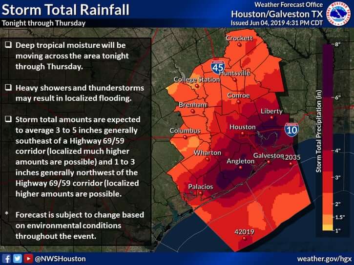
Click image for a larger version.
Exactly where it sets up is the big question. Some data has that big blob of flooding rainfall setting up just offshore Galveston. That would keep the flooding rains out in the Gulf of Mexico and keep rainfall totals immediately inland closer to two to four inches for the event. Other data has that band setting up onshore and in Southeast Texas, including the Houston metro (shocker, right?) and into parts of East Texas.
We won’t be able to exactly predict where that band sets up until we’re literally watching it form. If it sets up offshore we’ll have to deal with some localized flash flooding, street flooding, etc that is common-place with a good soaker. If that heavy band sets up inland we’re going to have problems because it could dump a foot of rain in several hours. I don’t care how dry it has been over the last few weeks – nothing good happens when you get a foot of rain in 3-6 hours anywhere outside of the ocean.
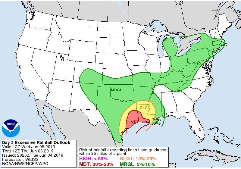
Risk of flash flooding (excessive rainfall) on Wednesday
Hopefully, that nasty band of water buckets sets up off-shore. Otherwise, we’ll probably get fairly busy late tonight and on Wednesday across portions of Southeast Texas. This does not look to be a widespread flooding event. Although if that band does drop a foot of rain inland we will have to deal with significant flooding – localized to where that very heavy rain falls. Of-course isolated flash flooding will be possible over a larger chunk of Texas in the coming days given the typical ‘summer-time’ popup storms. Those can easily drop 2-3 inches of rain in an hour, and that will cause flooding for a few spots. The quick burst of rain around San Antonio this afternoon was a great example of the hit and miss summer convection we experience.
A few stronger storms may also occur on Wednesday and Thursday. Widespread severe weather is not expected. The strongest storms could produce brief damaging wind gusts over 60 MPH, small hail, and a very low risk of a brief tornado. Tropical funnel clouds can be expected given the abundant amounts of moisture in place. Those rarely touch down, but sometimes do become brief and weak tornadoes.
You can keep track of the rain using our free HD interactive weather radar here on our website or in our free mobile app.


0 Comments