
Thunderstorm chances on a Sunday? Yeah, we’re not surprised either at this point. Our severe weather season that simply will not end continues to trudge on into late June. Unfourtinietly, we’ve got an active thunderstorm forecast for later today into tonight across portions of Texas. I’m going to start off by saying that this forecast is not a guarantee. Not every storm will be severe, not everyone will be impacted by a storm, and some folks aren’t going to see rain at all. Perhaps that will tide those who undoubtedly get upset because they weren’t impacted by severe storms today…. yeah, I doubt that’ll work, but it was worth a shot. Let’s get into it.
Click the image for a full-size version
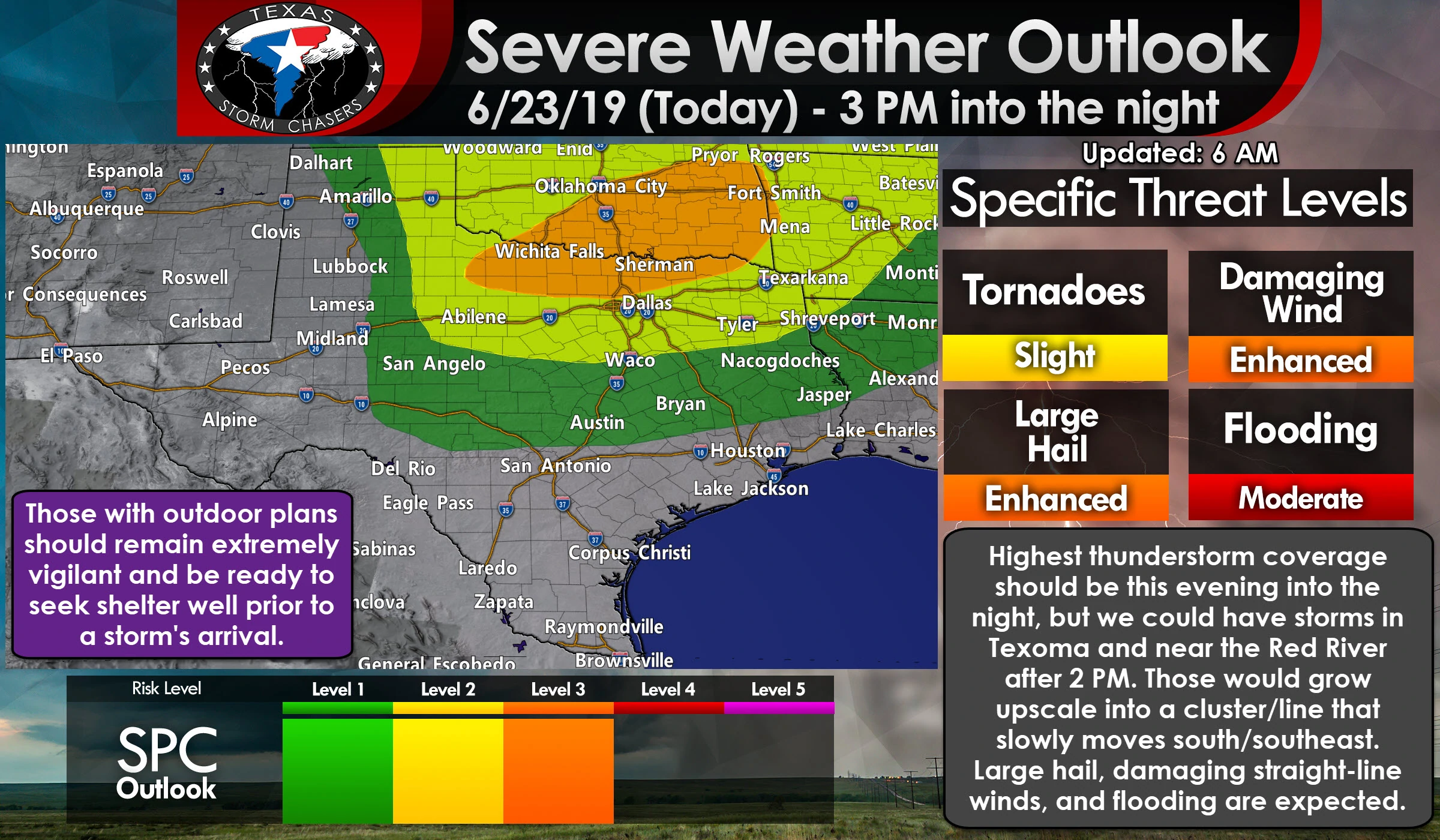
We have a level 3 risk of severe weather for this afternoon and evening across most of Texoma, the Red River Valley, into portions of North Texas. Vernon, Wichita Falls, Jacksboro, Gainesville, Denton, Sherman, and Paris are a few towns included. That is where confidence is highest in several severe storms late this afternoon and especially this evening as a line of storms moves south of the Red River. Those within this risk have a 30% chance of severe weather within 25 miles of any given point (such as your home).
We have a much larger level 2 risk that includes North Texas, the Big Country, Northwest Texas, and the eastern Texas Panhandle. Towns include: Perryton, Canadian, Pampa, Shamrock, Clarendon, Wellington, Childress, Crowell, Guthrie, Aspermont, Haskell, Sweetwater, Abilene, Graham, Stephenville, Hillsboro, the entirety of the D/FW Metroplex (who aren’t in the level 3 risk), Corsicana, Canton, Tyler, Longview, Greenville, Mount Pleasant, and Texarkana. This level 2 risk is where we have a 15% chance of severe storms within 25 miles of any given point (like your house).
Finally, a level 1 risk of severe weather includes the Concho Valley, Hill Country, Central Texas, the Brazos Valley, and East Texas. This area is where a few severe storms are possible but less likely than in the higher risk zones.
Here are several regional looks at today’s severe weather outlook. Click any image for a full-size version. Again, don’t pay too much attention to where the lines are drawn. If you’re in or near any risk zone you should keep an eye out later today and tonight.
Depending on how tonight’s thunderstorm complex behaves farther north I wouldn’t be surprised to see increased severe weather probabilities expanded a bit south. This is going to be a complicated forecast due to the storms overnight and into this morning across the Texas Panhandle and in Oklahoma. Those produced outflow boundaries which can spark off new storms. They can also drastically change a severe weather forecast. – Even though we expect most of the severe weather risk to develop starting in the late afternoon up on the Red River and into northern sections of Texas, I encourage everyone in every risk zone to keep an eye on the weather radar throughout the day.
Don’t be surprised if the severe weather outlook ends up looking different by lunchtime. That’s when we should have a better idea on exactly how today and tonight will play out – where all the features will set up, etc. We don’t want anyone getting surprised while out on the water or outdoors if a thunderstorm approaches. Even though we’ll still have some folks say they had no idea there was going to be bad weather today, but hey, you’re not one of them since you’re reading this post :).
This is how the forecast for today and tonight is looking this morning. Keep in mind that this will likely change based on how storms up north behave this morning and where all the outflow boundaries set up. Timing may end up being earlier, or a bit later, depending on those factors too.
We could have a few popup thunderstorms after 1 PM in the Brazos Valley and southern/eastern North Texas. Those would likely be more of your typical ‘summer’ popup activity with lots of lightning, brief heavy rain, and localized gusty winds. While not overly severe, those can be extremely dangerous to those outdoors and on lakes. They would generally move to the northeast. What we’ll be watching for is thunderstorms and associated outflow boundaries moving south from Oklahoma. Storms will probably be underway in Oklahoma throughout the morning and past lunch-time. Some of those storms may approach the Red River by the early afternoon. If that happens we may see the ‘start’ time for today’s event move up.
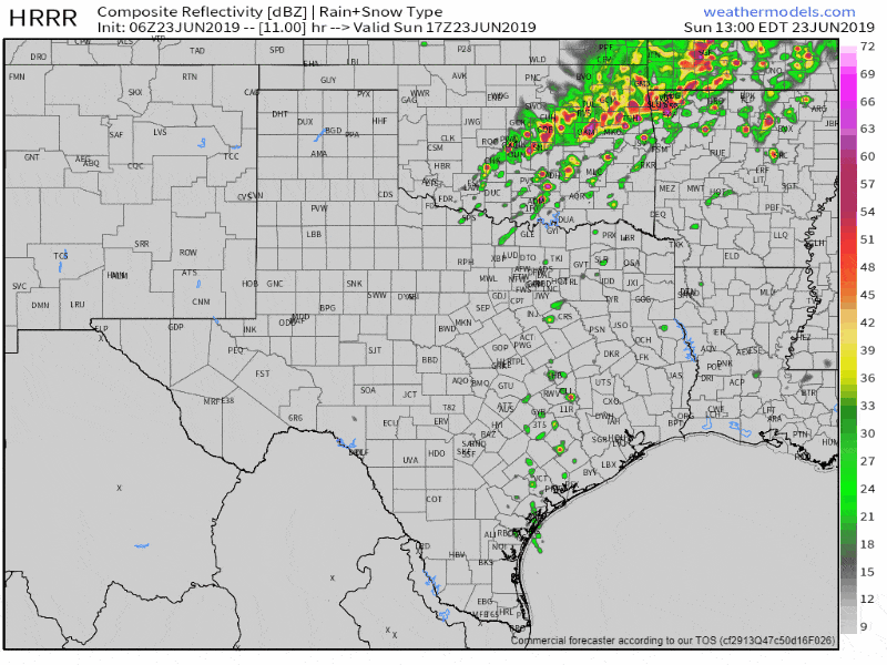
Simulated weather model radar from the 1 AM run of the High Resolution Rapid Refresh (HRRR) model going from noon today until 10 PM tonight. Only use this as a guideline and be warned that today is a day where these models probably won’t have a great handle on some of the small-scale dynamics. Those can impact a forecast.
New thunderstorm development is expected after 2-3 PM from the Big Country northeast into Northwest Texas and Texoma. Initial thunderstorms could produce large hail up to the size of golf balls. Any more intense supercell thunderstorm could produce very large hail up to the size of baseballs. I’m not sure how long that ‘initial supercell’ threat will last. There are indications of storms growing upscale into a squall line or thunderstorm cluster fairly quickly. Once that upscale growth occurs thunderstorms will begin moving more east/northeast versus northeast with a threat of quarter to golfball size hail and wind gusts of 60 to 75 MPH by the late-afternoon and/or the early evening hours. Some southward progression will begin this evening which should bring thunderstorms farther south in North Texas and East Texas.
Again, only the most intense thunderstorms will produce those hazards. Not all storms in the squall line will be severe, and not all storms today will produce damaging winds or very large hail. A tornado cannot be ruled out, but that threat is more unclear as of this writing and will depend on how we set up this afternoon. Very heavy rainfall rates, thanks to the summer atmosphere in place, will support some flash flooding. That threat of flash flooding will be highest where we see multiple storms move over the same areas (training) and/or over more urban areas that simply flood more easily.
So now you know what might play out later today and into tonight. It’ll be a good day to keep an eye on the weather radar. We’ve got a nice one here on our website and in our free mobile app. Stay up to date with weather information from your favorite meteorologists and the National Weather Service. We don’t want anyone dying today because they were caught outdoors on a lake and were surprised by a thunderstorm.


0 Comments