
The next several days will feature multiple chances of heavy thunderstorms in the proximity of a nearly stationary boundary across East Texas, Southeast Texas, the Brazos Valley, the Coastal Plains, extending west into Central and South-Central Texas. That means the northwestern half of Texas will experience several days of below-average temperatures along with a noticeable reduction in humidity. It’ll feel more like late March or early April versus mid-May.
The same will not be said for those dealing with heavy precipitation chances. I’ll go ahead and say now that we’re not going to get too detailed with the forecast beyond the near-term (next 18 hours or so). I’d rather be able to provide accurate short-term information versus trying to gander out into the abyss. I will say that Friday, Saturday, and Sunday are looking wet and stormy across East Texas, Southeast Texas, the Brazos Valley, and the Coastal Plains. It will not be raining all the time or for everyone, but the rain that does fall could do so in buckets.
Heavy rains over the last several weeks have left soils saturated, rivers/streams/lakes running high, and the aforementioned regions susceptible to new flooding with lighter amounts of rain. For your specific ‘blade of grass’ forecast for your location please visit the National Weather Service. Just plop in your zip code or city and you’ll have a more specific ‘when is it going to rain’ forecast. Remember, there are 254 counties in Texas and only one of me. 🙂
Click image for a full-screen version.
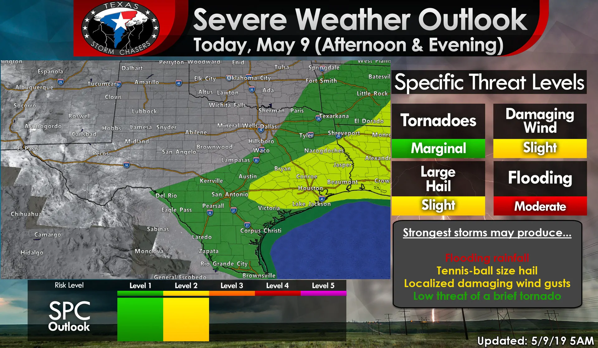
Temperatures in the upper 70s to 80s with dewpoints in the 70s across East Texas, Southeast Texas, back west into the Coastal Plains and Brazos Valley will result in extreme instability values this afternoon. As a cool front slowly moves south it’ll interact with that powder-keg of an airmass and fire up thunderstorms. Low-level wind shear is weak which will keep the tornado threat very low. The tornado threat is not zero, but it is a secondary concern.
Enough wind shear exists aloft to support high-precipitation supercells and organized clusters of thunderstorms. That means a few of the strongest storms this afternoon could drop some fairly large hail. Wet microbursts will also be a threat with localized wind gusts over 70 MPH possible. What will likely become the main story by this evening is flooding rainfall.
Thunderstorms won’t be moving very quickly this afternoon. They could congeal or form into clusters fairly quickly. Those clusters may ‘train’ or keep moving over the same areas as a train on a track. Given very high moisture values in place along with lots of instability we could see extremely heavy rainfall with 3-4″ hour rainfall rates under the heaviest storms.
It doesn’t matter if we were in extreme drought. 4 inches of rain in an hour will cause flash flooding to develop in a hurry. Saturated soils aren’t able to absorb much (if any) of the rain that falls – so it runs off. It won’t take as much rain to cause flooding to occur. Get one of those gully-washers over an urban area and the problem just gets compounded.
Click image for a full-screen version.
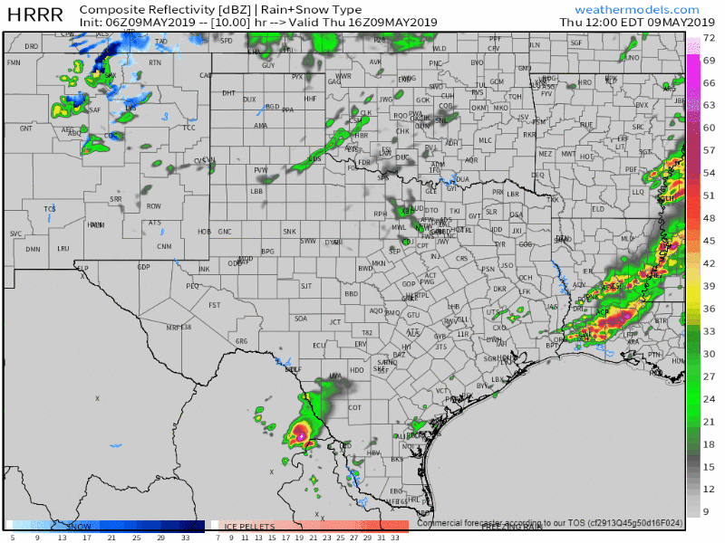
The High-Resolution Rapid Refresh (HRRR) model shows today’s scenario well. Thunderstorms will begin developing by the early afternoon hours as the cool front moves south and temperatures climb into the upper 70s to 80s. Storm coverage will increase during the late afternoon, much as you would expect during a typical summer day.
A few storm clusters could organize which would allow not only for higher rainfall rates but also increase the potential that storms could ‘sit over the same areas’ given the nearby slow-moving front. The threat of hail will decrease as storms become more clustered versus semi-discrete, but flooding will become more likely into the evening.
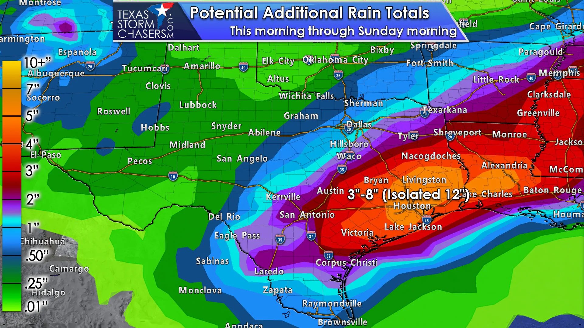
Click image for full-screen version. This graphic shows expected rainfall amounts on a regional basis. Some folks will get far less, some folks may end up doubling these estimates on a local scale.
Some folks won’t get rain at all today. Some folks down the road could get 8 inches of rain today. It’ll be those folks who get the 8 inches of rain in a few hours that will be dealing with a significant flood threat. All that water drains into creeks/streams/bayous which flood and those go into the river system and lakes which climb. Repeat that cycle multiple times over the coming days and you might understand why we’re concerned.
I said at the beginning of this post that I was only going to talk about today. However, this rainfall event will last through the weekend. Each day will bring a chance of more heavy rainfall. Each round of rain will only further reduce the amount of rain needed to cause new flooding the next time. It is entirely possible we’ll be dealing with a significant flood event across portions of the Brazos Valley, Coastal Plains, Southeast Texas, and East Texas by the weekend as rains continue to add up.


0 Comments