
Today is one of those rare days we don’t see often in Texas or Oklahoma. The best way I can describe it is that we’ll have the moisture and instability you’d expect in the summer with the very strong winds aloft seen with winter systems. It is indeed quite rare to see them combine in such strength – but it looks like that is going to happen today. I’m going to keep this post short and to the point. Most of the team will be chasing today so this may be our last blog update until tonight.
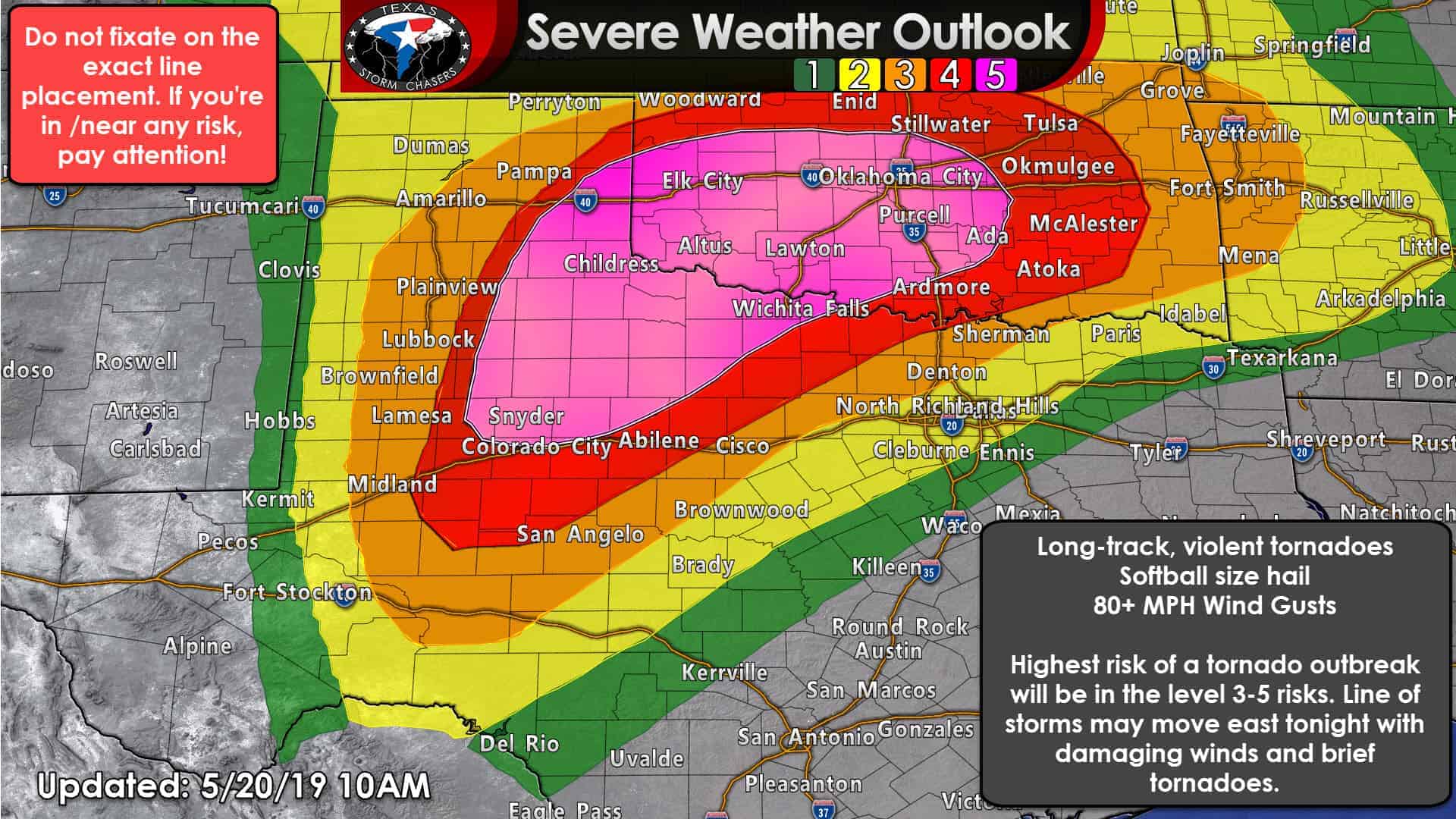
An outbreak of tornadoes, some potentially long-track and violent, is expected this afternoon into this evening over portions of West Texas, the eastern Texas Panhandle, Northwest Texas, into portions of the western Big Country and Concho Valley. This includes the potential for fast-moving destructive tornadic supercells capable of producing wide, long-track tornadoes. Not all storms will produce tornadoes, and not all tornadoes will be the long-lived variety.
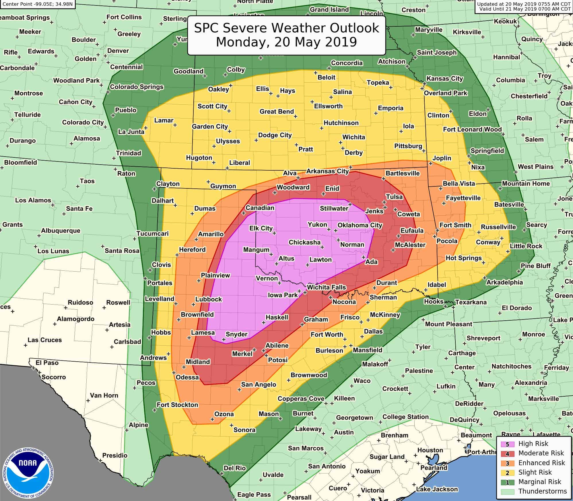
From the Storm Prediction Center:
“PUBLIC SEVERE WEATHER OUTLOOK
NWS STORM PREDICTION CENTER NORMAN OK
0922 AM CDT MON MAY 20 2019
…Outbreak of tornadoes and severe thunderstorms expected over
parts of the southern Plains today and tonight…
* LOCATIONS…
Much of Oklahoma
Northwest Texas and eastern Texas Panhandle
* HAZARDS…
Numerous tornadoes, several intense and long track
Widespread damaging winds, some hurricane force
Widespread large hail, some baseball size
* SUMMARY…
An outbreak of tornadoes, some potentially long-track and
violent, is expected today into this evening over portions of
northwest Texas into western and central Oklahoma. More-isolated
but still potentially dangerous severe weather, including
tornadoes and destructive winds and hail, is possible in
surrounding parts of Texas, Oklahoma, Kansas, and Arkansas.”
Giant hail up to the size of softballs and destructive straight-line winds over 80 MPH are expected with the most intense thunderstorms in the higher-risk levels. The most number of storms are expected in the higher risk levels. An isolated storm may develop in Texoma and North Texas this afternoon, although conditional, those would also be capable of severe weather before moving north/northeast into Oklahoma. Storms will be more isolated farther south into the eastern Permian Basin and Concho Valley. However, those storms may be just as intense with all modes of severe weather possible. Just because you’re in a level 2 or 3 risk does not mean you won’t have impactful severe weather in your area. It’ll just be a lower number of storms.
Storms this morning in the Texas Panhandle have been elevated above a cap. Those have produced hail and flooding, but are not tornadic. The threat of tornadic supercells will increase after lunch-time and definitely by 2-3PM. Storms will be moving quickly to the northeast at 40 to 50 MPH. It may not take long for storms to become severe and tornadic after they develop. Again, not all storms will produce violent severe weather, but there is a great concern we could be dealing with life-threatening hazards with the most intense storms. This is not a day where you should go out storm chasing unless you have a great deal of experience. This will be a dangerous day for professional storm chasers who have been doing it for years and decades.
Additional thunderstorms may develop across the Eastern Panhandle, West Texas, the Big Country, and Northwest Texas throughout the afternoon and early evening. This will make providing a specific timeline difficult since storms could pop-up wherever – and be fairly isolated (compared to a squall line). By the early evening, additional thunderstorms should fire up along the dryline near or east of Interstate 27 from the Texas Panhandle south into West Texas. Those storms could be discrete initially but should grow upscale into a bow-echo (or squall line). That line will move east toward Oklahoma, Northwest Texas, the Big Country, and Texoma. Widespread straight-line winds of 60 to 90 MPH are expected in addition to embedded tornadoes. Storms should be weakening as they move into North Texas late tonight or tomorrow morning, but we’ll have to watch carefully.
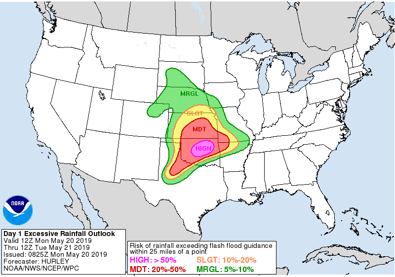
Flooding is a BIG RISK across the eastern Texas Panhandle, West Texas, Northwest Texas, and Texoma with storms tonight. As if the severe weather threat wasn’t enough, a very high-end flash flood event is anticipated across Central and Northeast Oklahoma tonight into Tuesday morning.


0 Comments