
Welcome to our long-time followers and those who may have just found us today. As is often the case during more active periods of Texas weather we have a lot of folks reading these articles. Before I get started with the latest forecast I want to go over a few pieces of helpful information. These forecasts are not written in stone. Mother Nature does not care what lines we draw on maps or what computer models indicate. Some days our forecasts are spot on while other days we get egg thrown in our face.
Please remember that the point of these forecasts is for you to keep an eye on the sky and your preferred weather radar app. When we discuss potential hazards we’re talking about the most intense or most severe storms. Not all storms will be severe and not everyone will get impacted by a storm. The ‘busted hail forecast’ from several weeks ago in North Texas has taught us that we need to emphasize uncertainties along with the ‘most likely’ forecast.
Understand that I’m not putting all this together at five in the morning to ‘get views’ or ‘go viral’. I’m not here to ‘hype’ or cause unnecessary concern. We don’t have nearly one million social media followers because we like causing panic over the ten years we’ve been around. I’m not trying to put together a forecast for a blade of grass in your backyard. That’s what your favorite smartphone app is for (although I recommend checking out your local forecast from the National Weather Service). With that out of the way let’s dive into the forecast for today. After that, we’ll talk a bit about what we’re expecting with the multi-day rain event.
Click image for a full-resolution/enlarged version.
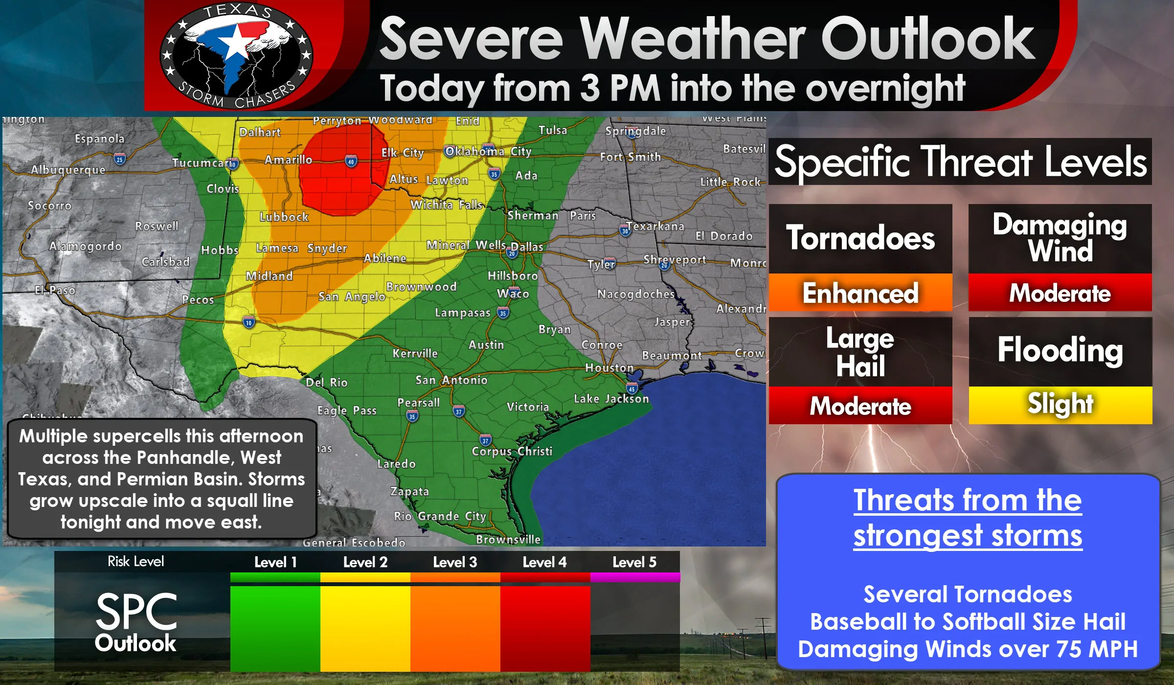
While we’re about to talk about several severe weather risk levels please understand that if you’re in or near any risk zone this is an early ‘heads up’ that active weather is possible in your area today or tonight. Don’t fixate on the exact placement of the lines as storms certainly don’t care.
The fine folks at the Storm Prediction Center, who issue the severe weather outlooks for the continental United States, have upgraded the eastern half of the Texas Panhandle and far Northwest Texas. Those regions are now in a level 4 out of 5 risks of severe weather – what is known as a ‘Moderate Risk’. Those in this level 4 risk have a 45% chance of experiencing severe weather within 25 miles of any given point (such as your home or business) – a nearly 50/50 shot!
This upgrade was issued as confidence continues to increase that multiple supercell thunderstorms will be capable of producing widespread very large hail. Storms that grow upscale later tonight into a squall line will be capable of producing widespread damaging straight-line winds in excess of 70 MPH.
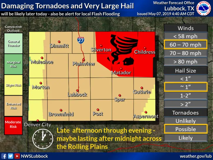
Tornadoes are expected with the most intense supercells from the late afternoon into the mid-evening hours across the eastern half of the Texas Panhandle (both the level 3 and 4 risk zones). If storms grow upscale into a cluster or squall line by 7 PM that’ll reduce the tornado threat. Likewise, if we’re dealing with discrete supercells after 7 PM we’ll see an uptick in tornado potential as wind shear values increase. I can’t rule out a stronger/long-lived (EF2+) tornado if discrete storm modes continue past 7-8PM.
A level 3 enhanced risk of severe weather includes much of the Texas Panhandle, West Texas, Northwest Texas, the western Big Country, and the western Concho Valley. Those in the level 3 risk have a 30% chance of severe weather occurring within 25 miles of any given point (such as your home or business).
Our standard level 2 risk of severe weather runs east to include western North Texas, the eastern Big Country, and much of the Concho Valley. The risk zones east of the higher levels far west will likely not deal with a severe weather risk until late tonight or pre-dawn Wednesday. That’s when we’re going to have a line of storms racing eastward. We’ll talk about that in detail below. Those in the ‘standard’ risk level have a 15% chance of severe weather occurring within 25 miles of any given point (such as a home or business).
Finally, we have a marginal level 1 risk including the Hill Country, Edwards Plateau, North Texas, Central Texas, South Texas, the Rio Grande Valley, the Coastal Plains, and the western half of the Brazos Valley. Much of that risk is due to scattered thunderstorms possible during peak heating this afternoon. Wind shear values are not going to be strong this afternoon that far east. Storms that fire will be diurnally driven, like those in the summer months. Very localized damaging winds (microbursts) and small hail are possible with the strongest storms. A quick bout of heavy rain is certainly possible too. Those ‘popcorn’ storms will dissipate as we approach sunset – and then we’ll have to wait for storms to approach from the west later in the night.
Here are regional graphics showing the severe weather outlook. You can click any image for a full-screen version.
We’ll be watching for a few different sources that could help ignite thunderstorm development this afternoon across the Texas Panhandle, West Texas, south into the Permian Basin. The most obvious source is the dryline which will be sitting not too far east of New Mexico by the early afternoon hours. However, we also have outflow boundaries left over from storms last evening and early this morning. Those outflow boundaries can often as a very localized source of ‘lift’ and help fire up storms. Just how strong (or weak) the cap or ‘lid’ on the atmosphere will dictate the timing and number of storms that fire up this afternoon.
Experience with the past several days along with high-resolution weather model guidance indicates we should see the first storms fire up in the Oklahoma Panhandle and northern Texas Panhandle fairly early in the afternoon, perhaps as soon as 1 PM. We may have to wait until after 3 to 4 PM across the southern Texas Panhandle south into the Permian Basin. Wind shear values will be increasing as we get into the late afternoon and early evening hours. Regardless of timing, the atmosphere is going to be quite unstable and certainly supportive of hailers. Localized damaging wind gusts are also expected with the strongest storms ‘up and down’ the dryline.
If my thinking is correct we should see several hours of scattered discrete to semi-discrete supercells versus a widespread line or blob. Not all of those supercells will be producing giant hail or pose a risk of tornadoes. Storms should generally move off to the northeast around 20 to 30 MPH. Splitting storms may create left and right splits. Those left-splits would move to the north/northeast at closer to 40 MPH with a large hail risk. The right-splits would tend to move more east/northeasterly at 20 to 25 MPH. It will be the right splits that could pose a comparatively higher risk of producing a tornado.
Low-level wind shear will be modest during the early and mid-afternoon. However, as our upper-level storm system draws closer by the late afternoon, we’ll see wind shear values increase. That would increase the potential of more organized/longer-lived supercells and an associated threat of tornadoes across the Texas Panhandle. Low-level wind shear will be weaker farther south across West Texas and into the Permian Basin. However, given very high instability values and potential for outflow boundaries that can locally enhance shear, isolated tornadoes will be possible in those regions. However, the highest tornado risk *should* be farther north in the Texas Panhandle and far Northwest Texas by the late afternoon and early evening hours.
A caveat for the tornado potential will be storm mode by the time wind shear values increase by the early evening. If storms are already growing upscale into a squall line – or we have too many storms in one area, the tornado threat would remain isolated. However, if we have sustained, intense supercells ongoing at 7 PM, they’ll probably be tornadic. Regardless, we’re going to see some big hailers today – with larger hail sizes than the last couple of days. Hopefully, we can keep the number of tornadic supercells limited to one or two.
By the mid-evening hours, we should have a line of thunderstorms organizing in the eastern Texas Panhandle, western Oklahoma, southward into Northwest Texas, West Texas, into the eastern Permian Basin. This process could be underway as soon as 7 PM, or it may hold off until we get closer to 10 PM. (Tornado threat is higher with discrete supercells between 7 PM and 10 PM, so hopefully, we’re in a squall line). Linear storms have a lower tornado threat but will have an increased potential of producing damaging straight-line winds. In tonight’s case, we could see a more widespread threat of damaging straight-line winds between 60 and 80 MPH. That’s one reason we have level 3 and level 4 risk of severe weather in place.
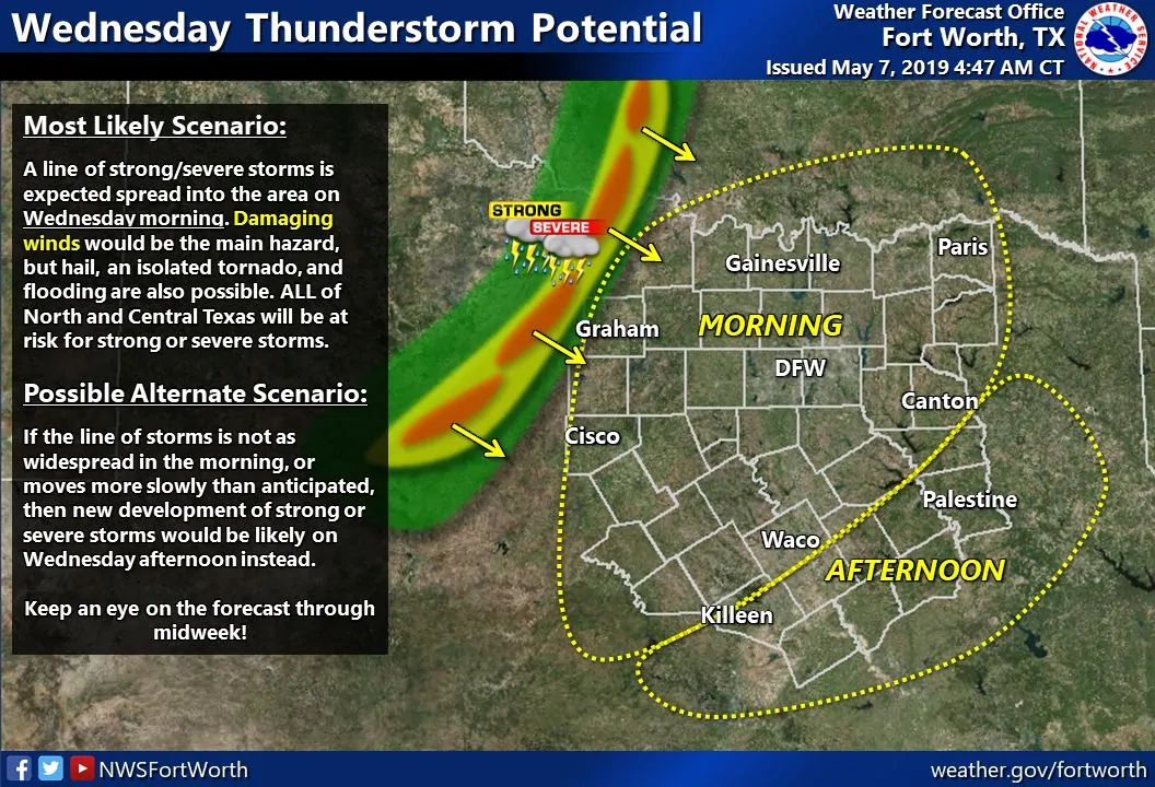
The line of storms will move east into the Big Country and Concho Valley late this evening and overnight. The most intense storms in the squall line could still be producing golf ball size hail and wind gusts over 70 MPH. Forward storm motion to the east will increase once the line organizes this evening and ‘bows out’. Storms will enter western North Texas between 2 and 4 AM and approach the D/FW Metroplex between 5 AM and 7 AM while slowly weakening. Upper-level lift and a stronger cap farther south in the eastern Concho Valley and Hill Country should allow the line to weaken more quickly early tomorrow morning compared to farther north. However, that’s not guaranteed and is one uncertainty.
Another possibility, albeit low at this point, is that the line of storms never really gets too organized south of Interstate 20 tonight. That would keep the line of storms mainly north into Oklahoma, Northwest Texas, and Texoma. If that occurred it would place a big role in tomorrow’s severe weather threat farther east.
At this time we believe the most likely scenario is that a line of showers and thunderstorms will be moving east across North Texas extending south into Central Texas tomorrow morning (after 7 AM). Storms should be slowly weakening, although it’s possible we may see new storms fire up just ahead of the squall line by mid-morning. Those new storms would help keep a threat of damaging winds and large hail ongoing into the Brazos Valley and East Texas tomorrow afternoon.
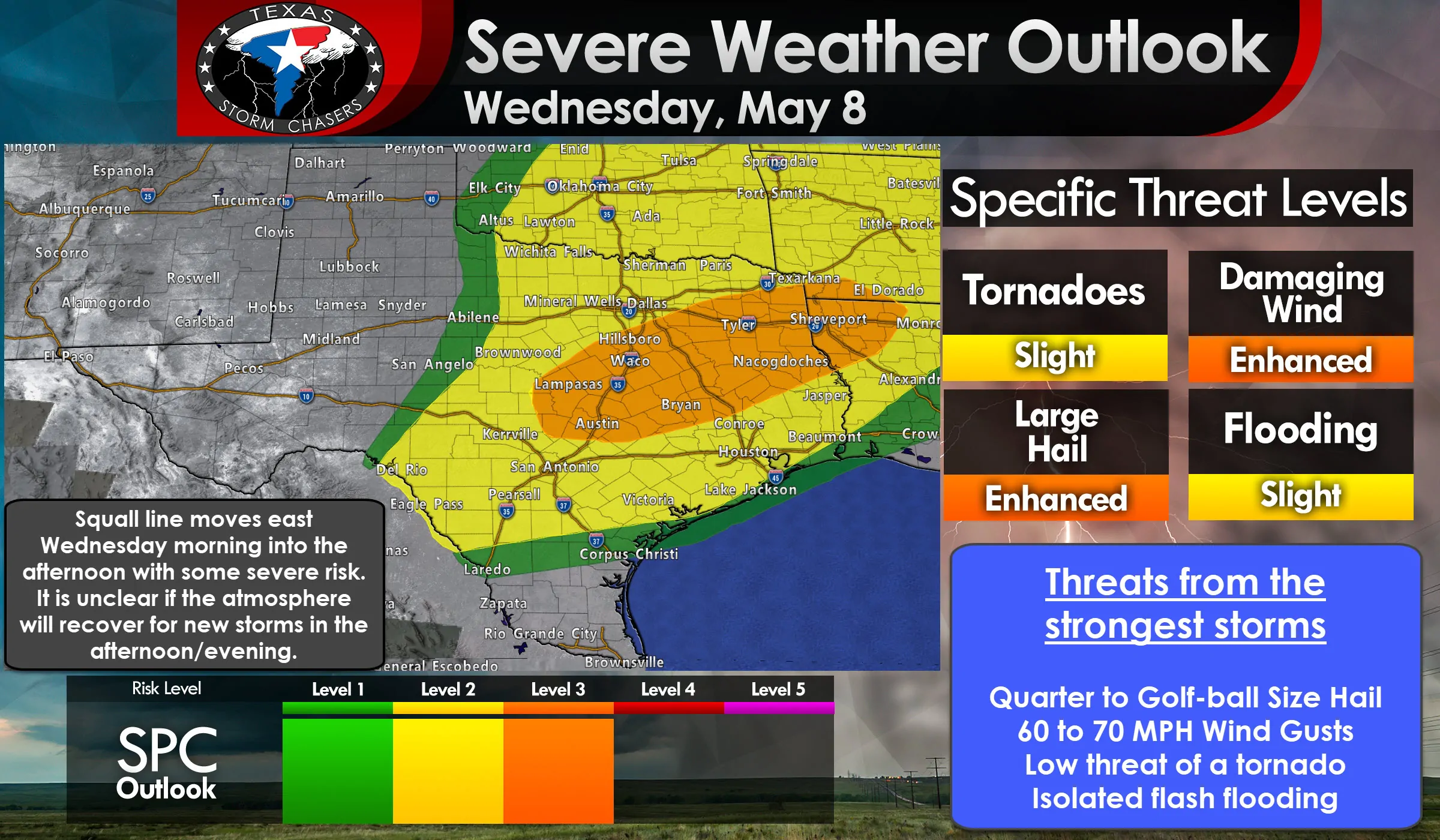
If the line of storms weakens tomorrow morning and does not impact southern North Texas, Central Texas, and the Brazos Valley we could see those regions become quite unstable by Wednesday afternoon. Scattered supercelluar thunderstorms would likely develop and be capable of producing very large hail, localized damaging winds, isolated tornadoes, and flooding rainfall as they move east/northeast. That’s why we have a level 3 enhanced risk of severe weather in place along a corridor across Central Texas into East/Northeast Texas.
Tomorrow’s severe weather outlook is one of low-confidence and I expect we could see some fairly substantial changes in future outlooks. If the squall line is able to roll through in the morning and rain/clouds stick around into the afternoon the overall severe weather threat would lessen. If that line of storms stays up in Oklahoma/Texoma and we have an unstable airmass in place tomorrow afternoon across North Texas and Central Texas we would see a fairly substantial severe weather risk. I’m betting on the ‘squall line’ solution with some new development along/ahead of it tomorrow morning and tomorrow afternoon versus the ‘squall line stays north and we get a bunch of mean supercells’ solution. However, I strongly encourage you to check back for forecast updates this evening and tomorrow morning from the National Weather Service and your favorite television meteorologists. Most of us at Texas Storm Chasers, myself included, will be chasing today and we won’t be able to crank out these massive blog updates this evening (most likely).
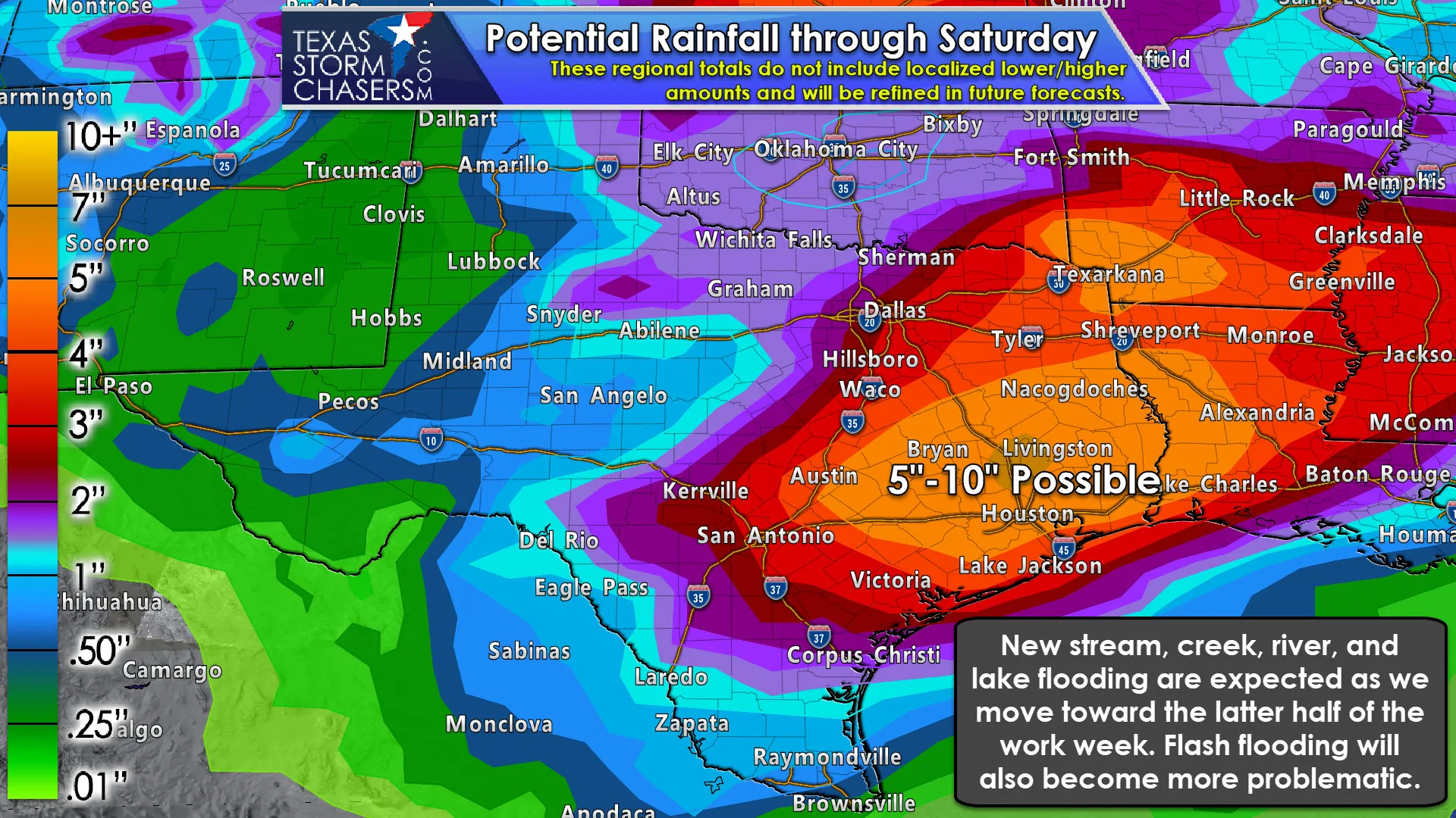
On the backside of all this mess, we’ll see an unseasonably pleasant cool front move south through the northern two-thirds of Texas by Thursday. Conditions north of the front will be much less humid with overnight lows getting diving below average for mid-May. Some folks are going to get down into the 40s with a dry airmass. However, the front is expected to stall out somewhere in Southeast Texas extending southwest into South Texas. Moisture values will remain abundant near and south of that front – which itself will act as a source of lift. Multiple waves of upper-level lift will overspread those regions on Thursday, Friday, and Saturday. I won’t say it’ll rain all of that time, but I will say we expect multiple rounds of heavy rain and storms to ‘train’ near that front.
Click image for full-screen resolution.
Widespread rain totals over 3 to 7 inches are expected across East Texas, Southeast Texas, the Brazos Valley, extending into the Coastal Plains. Localized rain totals approaching 10 inches will be possible in the timeframe from Thursday through Sunday. There will likely be localized flash flooding issues with the overall threat of flooding increases as soils become more saturated by Saturday. I’m optimistic we can ‘spread out’ those heavier rains over the next several days. However, some folks probably will get several inches of rain in a few hours where we have heavy storms move over the same areas. Those will be the spots where flash flooding is most likely.
River flooding and ‘flood waves’ moving down multiple river flood systems will be problems by the weekend and for much of next week. Remember that whatever rain falls in northern portions of Texas has to flow downstream – into the same areas that are going to get even higher rainfall amounts. Multiple rivers will probably enter a moderate flood stage, with a few hitting ‘major’ flood stage.
We’ll deal with the multi-day rain threat and refine the threat for flooding once we get past today and tomorrow. We’re in May so expect active weather to continue through most of the month. Dealing with severe storms and heavy rains aren’t unusual in May, although we’ve certainly seen our fair share of big rain events over the last several years. I’m not saying this upcoming heavy rain event will become a ‘major flood event’, but flooding will become more likely by the time we’re into the weekend.
We still need to get past the next two days before we can focus on the heavy rain threat across the southeastern half of Texas. Remember, you can always get your local forecast from the National Weather Service and your favorite television meteorologists. Those in Southeast Texas can also check out Space City Weather. They’re a great group of folks who provide great forecast information for Houston and surrounding areas.


0 Comments