
A line of strong to severe thunderstorms moved across Northeast Texas, East Texas, and the Brazos Valley earlier this afternoon. That line is now moving into Mississippi. Back west in East Texas we’re starting to see southerly winds return along with some destabilization. While we are approaching sunset, strong upper-level dynamics in combination with a warm front moving north are allowing for the atmosphere to destabilize once again. There is a risk of more severe storms later this evening and into the early morning hours on Wednesday – conditional on new storms firing up.
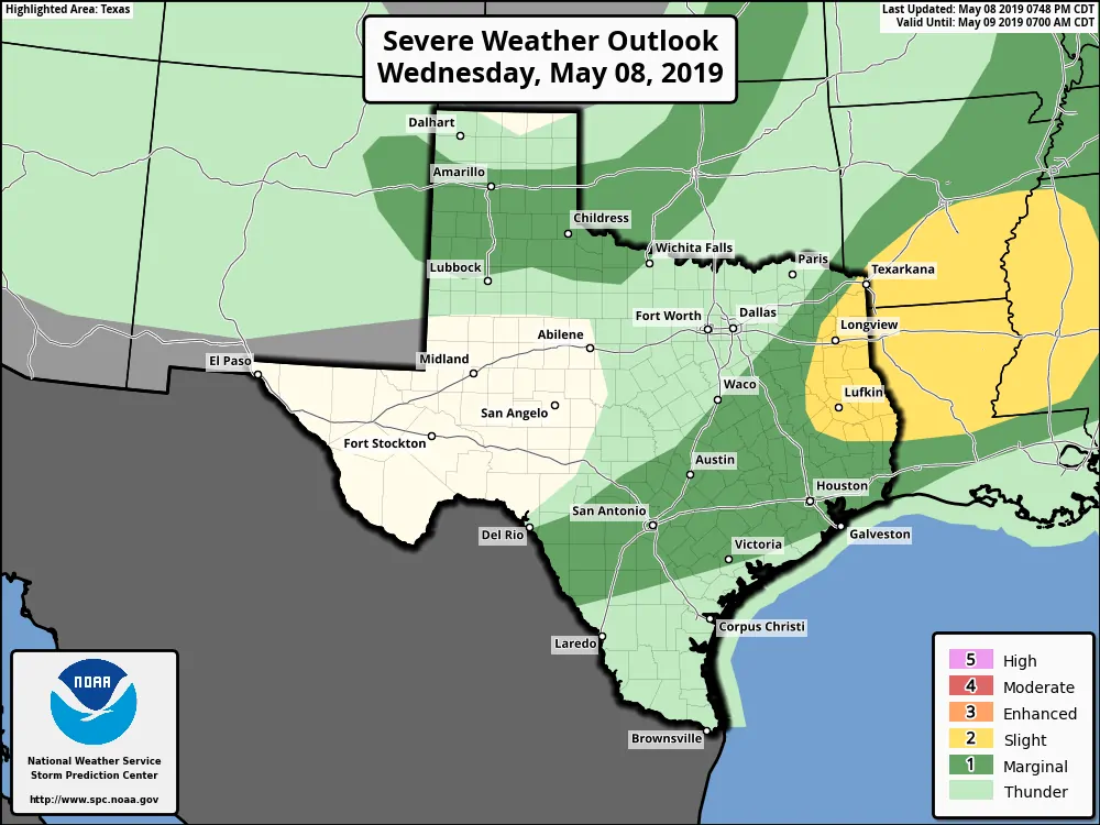
Tonight’s severe weather outlook
The Storm Prediction Center maintains a standard level 2 risk of severe weather tonight for East Texas. There is a marginal risk farther to the southwest, but our focus and concern are on the potential for new supercells in the level 2 risk.
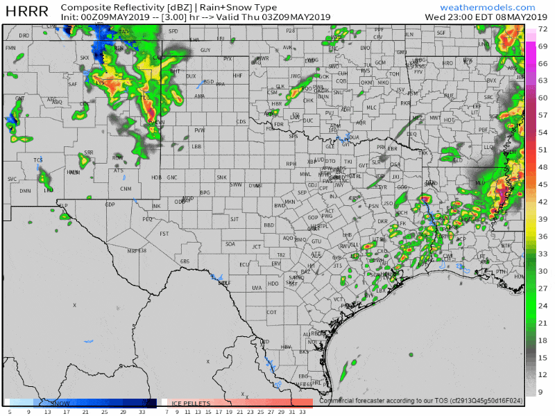
0Z HRRR: Simulated weather radar from 10 PM tonight through 6 AM Thursday. This model may be overdoing the coverage of thunderstorms, but its signal is clear in terms of new development later tonight.
One reason I’m concerned is that short-term high-resolution weather models are in decent agreement on storm redevelopment after 10 PM. Assuming the warm front is able to move north we should see an environment supportive of severe storms. The strongest storms could produce large hail, localized damaging winds, and at least a low threat for tornadoes. Wind shear values south of that warm front will be strong, so we will have to watch for a tornado threat *if* organized supercells develop south of the front. That’ll mainly be a threat for Far East Texas and Far Southeast Texas. Those storms will move northeast into Lousiana by 3 AM Thursday.
I want to emphasis that this is more of a ‘worst case’ scenerio conditional on intense storms being able to develop and organize. It is entirely possible the atmosphere is too worked over to support another round of severe weather. However, the close proximity of higher moisture moving back north along with strong wind shear warrants a ‘heads up’ on that more severe storms are possible later tonight. Even if new storms develop they would not impact everyone – and not all storms would be severe.
Heavy rain and flood event Thursday-Sunday
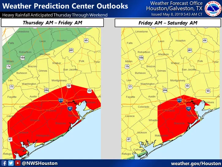
From NWS Houston: “The Weather Prediction Center has upgraded to a moderate risk for excessive rainfall for both Day 2 (Thurs AM into Fri AM) and Day 3 (Fri AM into Sat AM). Therefore, forecasted rainfall totals estimate about 5-8 inches widespread, with isolated 9-12 inches possible Thursday through early Sunday. Keep in mind these totals could very easily occur in one day, as we recently saw yesterday.”
While strong thunderstorms will be possible tomorrow through the weekend across parts of Texas we’ll be shifting our focus to the threat of new flooding. A stationary front, very high moisture values, and multiple ‘waves’ of upper-level lift will set the stage for an excessive rainfall event across parts of East Texas, Southeast Texas, the Brazos Valley, back west into South-Central Texas. Widespread additional rain totals of 3 to 8 inches are expected from Thursday through Sunday. Localized additional rain totals may exceed one foot in some locations.
Given flooding experienced in the Houston metro yesterday in combination with saturated soils we’re expecting additional flooding to develop. That’ll include flash flooding on creeks, streams, and bayous where the heaviest rains fall in a short period of time. Keep in mind it won’t take much rain to cause flash flooding given most rain that falls will simply run-off. Soils are too saturated to absorb much rain. We’ll have to deal with rising river and lake levels through much of May.
We’ll talk more about the flooding threat once we get past tonight.


0 Comments