
We’ll be entering back into an active weather pattern beginning tomorrow, a break on Sunday, and right back into the ‘fun’ beginning Monday of next week. That stretch will continue through at least the first half of next week. Last evening I shared a note on social media saying that we weren’t talking too much about the upcoming severe weather chances because of some uncertainties and the fact we deal with severe storm chances on a regular basis in May.
I’m not going to cause a fuss by hyping, nor will I downplay a potential high-impact event. I’ll tell you what we know (as much as a forecast can) and also tell you what we don’t know (uncertainties or ‘bust potential’ in a forecast). I’m aware that many are still on the ‘giant hail bustola’ from April in North Texas. Yes, we’ve had busts this spring, just like your NCAA bracket. I own up to them and try to explain them afterward. Now that I’ve got my little morning dialog out of the way let’s start talking about the threat for storms on Friday and Saturday.
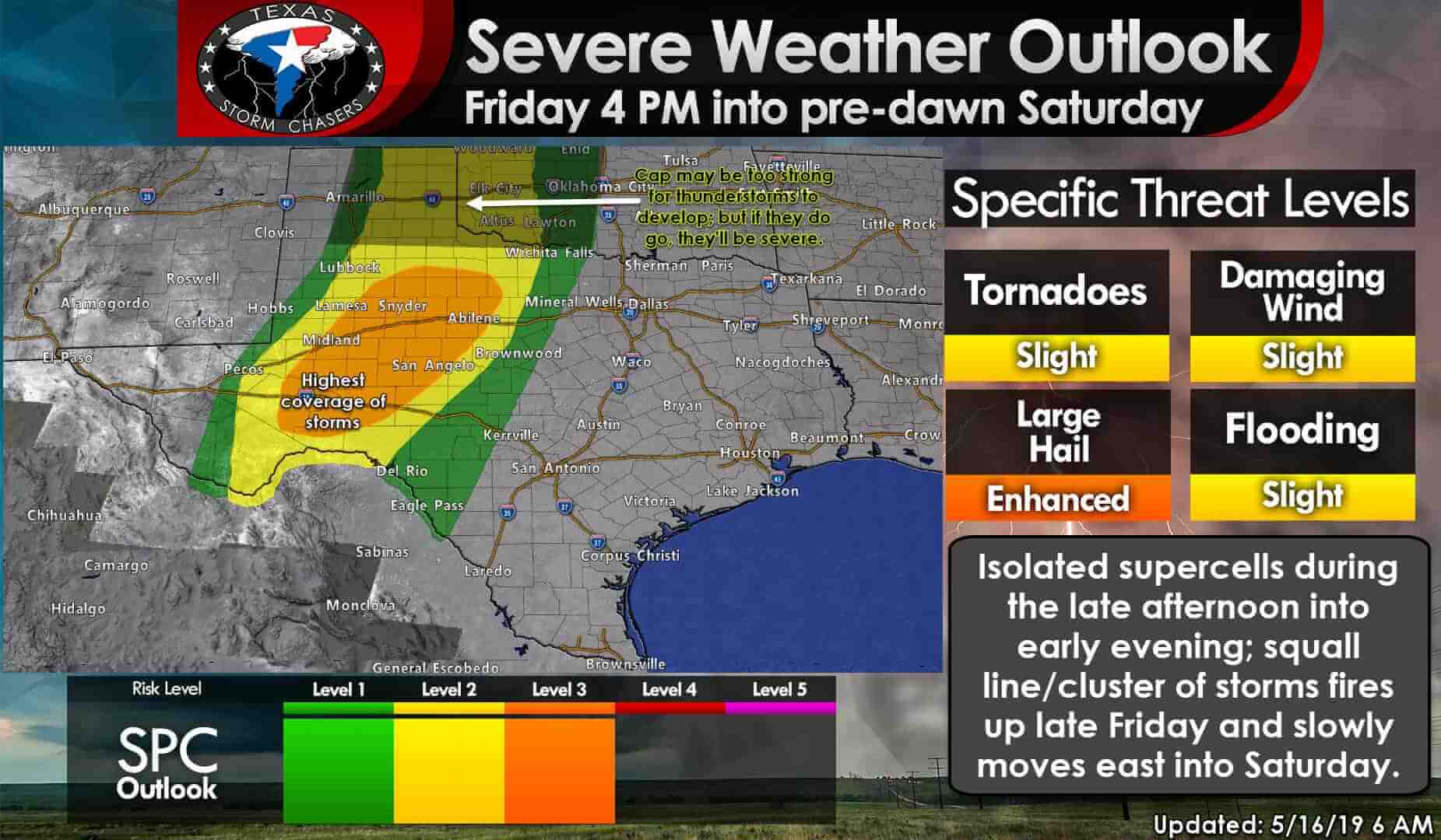
Friday’s severe weather outlook from the Storm Prediction Center. Click on the image for a full-screen version.
Isolated to widely scattered thunderstorms could develop as soon as 4 PM across West Texas on Friday. Those storms would fire up just east of a surface dryline. I don’t think there will be many storms – as in there may only be two or three from the Mexico border northward toward Childress. Those storms that do develop in the afternoon will likely be superceulluar.
Those storms could produce baseball size hail, localized damaging wind gusts over 70 MPH, and perhaps a few tornadoes. The number of storms will be limited by the cap during the daytime hours. Thunderstorm coverage will drastically increase after sunset and into the late evening hours as the dryline ‘unzips’ due to arriving strong upper-level lift.
Thunderstorms in the eastern Texas Panhandle are more uncertain tomorrow. Weather models have trended toward a stronger cap and some subsidence aloft (sinking air). That could keep the atmosphere ‘capped’ and prevent thunderstorm development. However, if a storm is able to develop in the eastern Texas Panhandle tomorrow afternoon, that storm would be superceulluar with all modes of severe weather possible. Low-level wind shear is more impressive across the eastern Panhandle (northward into Kansas) compared to farther south. That isn’t to say there wouldn’t be at least a low-end tornado threat across West Texas late tomorrow afternoon or evening.
The stronger upper-level lift arriving tomorrow evening should result in scattered to numerous thunderstorms erupting across Northwest Texas, the Big Country, Concho Valley, and Permian Basin. Even with the late hour, the atmosphere will still be quite unstable with plenty of wind shear in place. Strong to severe thunderstorms are expected.
Upscale growth into a squall line or cluster is expected fairly quickly. However, some storms may remain superceulluar within that squall line. The strongest storms tomorrow night into Saturday morning could produce golfball to hen-egg size hail (1.75”-2”), straight-line winds up to 75 MPH, and a few tornadoes. Any bowing line segments or embedded superceulluar structures that are able to develop strong mesocyclones could produce brief tornadoes as the squall line moves east tomorrow night.
Eastward movement may not be particularly quick, so heavy rainfall may result in localized flash flooding. Soils are saturated so we’ll have to watch for rapid rises in streams, creeks, and rivers (both in and downstream of areas that get a boatload of rain tomorrow night).
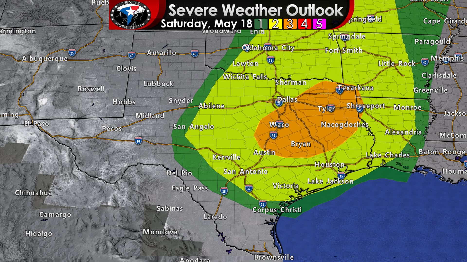
Saturday’s severe weather outlook. Click image for a larger version.
This is where the forecast starts becoming more unclear. If the squall line develops into more of a wind-maker it would tend to move east more quickly toward Texoma, North Texas, and Central Texas. However, if that ‘cool pool’ process doesn’t occur, the storms may only make slow eastward progress. The strongest storms would still be capable of producing severe weather (hail, high wind, brief tornadoes) in addition to a higher heavy rain threat.
I mention that because the slower eastward movement would result in the storm cluster not making it into North Texas until after 7-8AM Saturday. Storms would then move east to the Interstate 35 corridor from Oklahoma City south to the D/FW Metroplex late morning to around noon on Saturday. Some storms could still be severe. An organized squall line would move more quickly east and bring a damaging wind threat to North Texas, East Texas, and Central Texas Saturday morning and Saturday afternoon. Storms in North Texas and Central Texas, whether they’re part of a squall line or new storms out ahead of the line, could intensify Saturday afternoon as they move east. Those would make it into Northeast Texas and East Texas by Saturday evening. This aspect of the forecast will be refined by Friday morning.
Regardless, storms should move east of Texas late Saturday into Sunday morning. Sunday should be a ‘down’ day across Texas as we’ll be in-between storm systems. However, a new one will arrive on Monday. That’ll bring the return of thunderstorm chances to parts of Texas by Monday afternoon. The threat of severe weather and an increasing threat for heavy rainfall/flooding will continue into Tuesday and Wednesday.
Let’s get through the Friday and Saturday storm system before we focus too much on whatever evolves out of next week. It certainly is one of our more active springs – and that looks to continue through the end of May.
Remember! These posts I write up are meant to provide a general overview and a ‘heads up’ mentality. Most of the time forecasting the high temperature and chance of rain at your house isn’t too difficult (which is why your smartphone can do it). Forecasting more hazardous weather requires a greater level of knowledge, experience, and similarities to a punching bag.
There are only a few guarantees in life in Texas (or the south in general). The bugs will eat you alive during the summer, it’ll be annoyingly humid at some point, traffic is a way of life in the city, and that the forecast is always changing.


0 Comments