
Multiple tornadoes impacted Northeastern Oklahoma and Missouri last night. At least three people are dead and that was before a significant tornado impacted Jefferson City, Missouri around midnight. It will take several days for the official damage surveys to be completed. Once those are done we’ll find out just how many tornadoes occurred yesterday and this morning across those states. Here in Texas, we did have a wee bit of mischief last evening as a supercell was able to develop near Seymour and move northeast to Burkburnett. It did produce a couple of funnel clouds, but those did not touch the ground. A strong cap prevented thunderstorms from firing up farther to the south. That will not be the case today as we shift our focus back off to the west.
Just a reminder: All of the images included in our posts can be clicked on for a full-screen version.
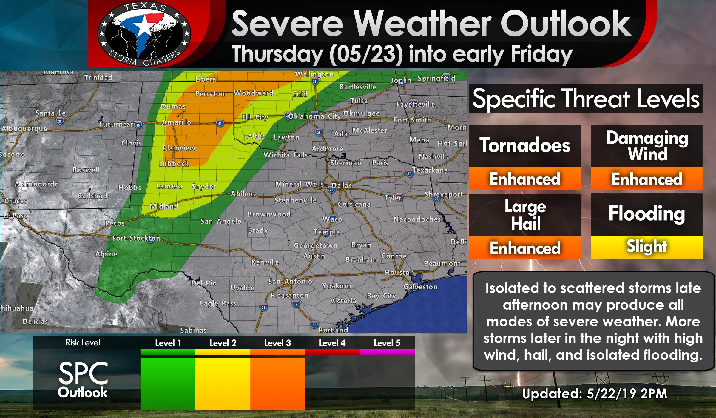
The Storm Prediction Center has placed a level three risk of severe weather across the eastern half of the Texas Panhandle. That enhanced risk extends south along/near Interstate 27 to Lubbock and off to the east/northeast to Childress. A level three out of five, with five being the highest, means there is a 30% chance of severe weather occurring within 25 miles of any given point (such as your home or work). This higher risk is also where the threat for tornadoes is expected to be relatively highest with any discrete supercells by the late afternoon and early evening hours.
A level two risk – the standard risk level – includes portions of West Texas south into the Permian Basin and western Big Country. The number of storms should be lower compared to the higher risk level to the north. That does not mean severe weather is unlikely, it just means storms should be fewer in number. They could be just as severe as those in the higher risk level. Finally, a level one risk extends south to include Pecos, Fort Stockton, Alpine, eastward to just west of San Angelo to Abilene to Quanah. Storms will be moving northeast versus east and a strong cap should prevent development from making it east into Texoma or the Hil Country.
The strongest storms today could be capable of producing very large hail, localized damaging winds, and isolated flash flooding. Tornadoes are not out of the question. We’ll be watching the eastern Texas Panhandle for the highest threat for tornadoes this afternoon into the early evening hours. Whatever tornado threat develops will be dictated on whether or not we still have discrete/semi-discrete storms after 6-7PM. If storms are clustered or in line segments, the threat for tornadoes would remain low. However, we will need to watch trends closely as some uptick in tornado potential could exist early this evening.
I expect that by the time you read this post we should have some thunderstorms ongoing across the Texas and Oklahoma Panhandles. Those storms this morning could pose a threat for some hail, gusty winds, and heavy rainfall. Those storms may grow upscale into a squall line that will make its way into Kansas by the early afternoon hours. How the atmosphere recovers behind the storms will help dictate any corridors of higher severe weather threat.
At this time it looks like the eastern half of the Texas Panhandle will be ‘the zone’ where ingredients come together to support new supercell development by the early-afternoon hours. In fact, we may see numerous thunderstorms fire up this afternoon. Those cells will move off to the northeast toward western Oklahoma. We could see several ‘waves’ of storms through the afternoon and evening hours. Any cells that are discrete after 6-7PM could have a somewhat greater tendency to become tornadic in the eastern Texas Panhandle south into West Texas. Very large hail and localized damaging winds will be possible with the most intense storms throughout the afternoon and evening.
Storms should fire up just east of the dryline near Interstate 27 by the late afternoon hours. Those storms could be severe as they move east/northeast through the early evening hours. Very large hail, localized damaging winds, isolated flash flooding, and a low tornado threat will exist. Storms may grow upscale into a small cluster as they make their way toward Childress by the mid-evening hours.
Even more storms (like round 4 by this point?) could develop after 9 PM across the Texas Panhandle south into West Texas as another wave of upper-level lift arrives. Yet again some storms may be severe as they grow upscale into another squall line. That line will make slowly its way toward Western Oklahoma and Northwest Texas after midnight. If it ‘stalls out’ we could see flash flooding become a higher threat in far Northwest Texas overnight.
Of course, all of what I just described will probably change somewhat as we get into the day and see exactly where all the ingredients are setting up. Outflow boundaries from storms yesterday and this morning could become focal points for new development later this afternoon. In addition, we’ll have to see if we have any corridors of enhanced low-level wind shear develop near those boundaries.
There are also some hints that a weakness or veering of winds around 4,000 feet ASL. If that develops (we call it veer-back-veer in the wind profile) we could see storms tend to stay ‘messy’ versus become extremely organized in the tornado department. Anyway, we’ll just have to wait and see. We’ll be chasing in the Texas Panhandle later today so be sure to stick around our social media channels for live video, photos, and chase updates. Follow your local National Weather Service office for the latest weather updates for your specific location.


0 Comments