
We’ve heard from many of you today. Many are thankful we got away without any major hailers last night, while some are having less favorable opinions on the matter. Every weather event can be a learning experience. Those who forecast and share weather information with the general public not only have to deal with the methodology, but they also have to increasingly deal with societal science (how will the general public respond). I want to take a few moments to reflect on yesterday’s setup, what went “wrong” with the forecast, and some personal reflections from someone who shared the forecast for several days in advance.
We still had a dryline, we still had instability, we had moisture, and we had strong-upper levels winds. Yet for most of the late afternoon Wednesday, we were dealing with line-segments that were still producing hail. Sure, some folks received quarter to golfball size hail, but we had been warning of baseball to softball size hail for days. Why didn’t that happen? Of interest to me personally, and more related to social science, is why yesterday garnered such a furor.
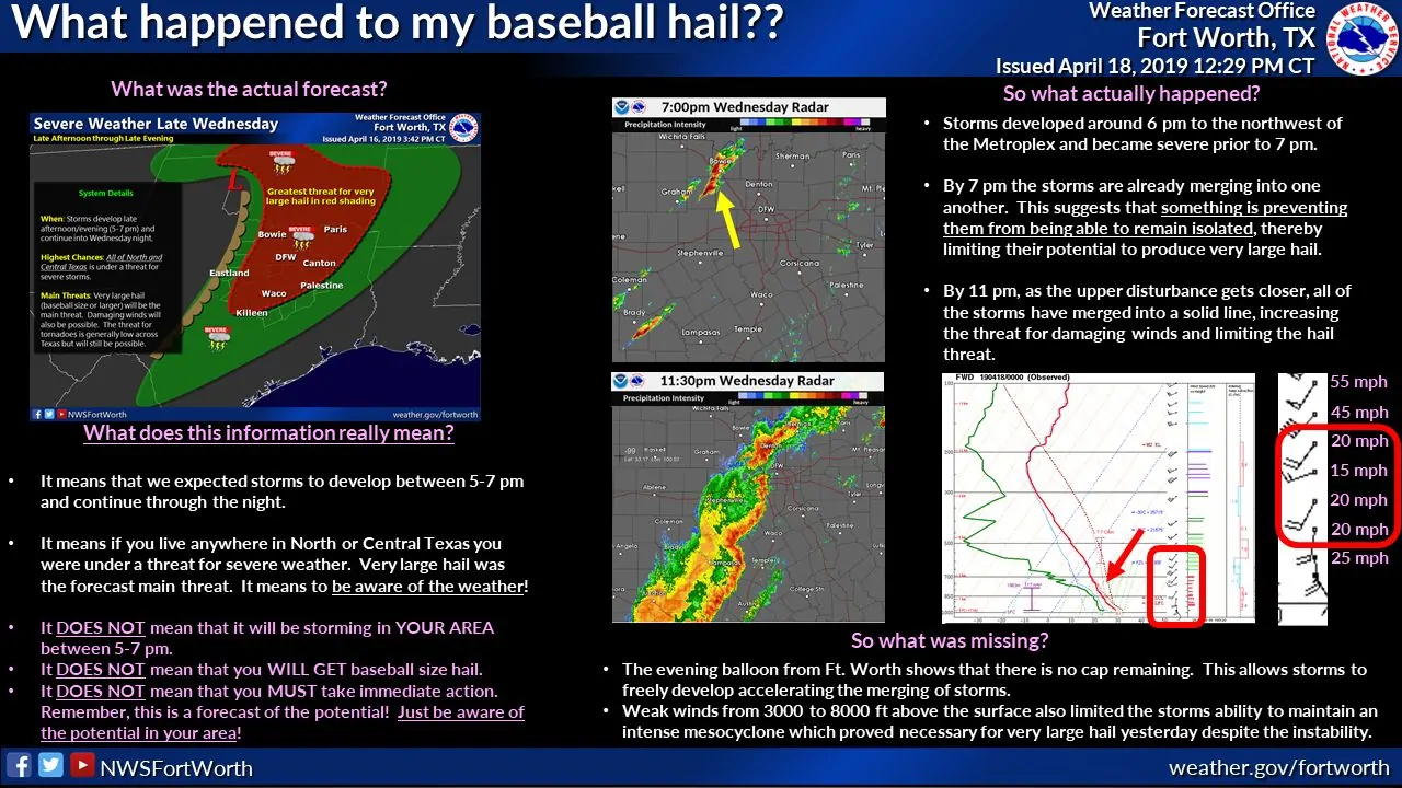
From a meteorology perspective, there were two noteworthy items that helped prevent a significant hail threat yesterday in North Texas. The first was an area of weak winds between 3,000 and 8,000 feet above sea level. While we had strong winds aloft, those weak low-level winds prevented storms from developing intense mesocyclones. However, the bigger factor was that storms all fired up around the same time.
Those of you monitoring radar yesterday may have noticed that storms from Jack county northeast into Montague county didn’t look like your typical supercell. There were no hooks, no distinct hail cores, and they weren’t by themselves. Instead, storms had a more linear shape to them. When one storm would start to become better organized a new one would form just to its south/southwest – cutting off it’s unimpeded supply to warm, unstable air. That process repeated several times between 6 PM and 10 PM yesterday. We have had events where the cap is too strong to allow thunderstorms to develop. Yesterday the cap actually was eliminated completely, so when sinking air aloft (behind an early-afternoon storm system that brought clouds/showers to North and East Texas) was eliminated, storms fired up all at once. With storms fighting with each other, we did not have one single storm become dominant and produce that very large hail we had been concerned about.
Had that weakness in low-level winds not been in place we may have had several severe storms with very large hail in North Texas yesterday. Even though we had storms fire up all at once, if that wind field weakness wasn’t in place, I bet we would have still seen several organized supercells. That wind field weakness corrected itself around 10 PM last evening, but storms had already grown upscale into a squall line. Instead of having very large hail, that squall line produced damaging winds across the Brazos Valley and East Texas early this morning. If you don’t believe me just check our community group on Facebook for pictures of trees fallen onto (or through) homes.
Now for a few personal thoughts on the amount of attention yesterday’s event received from the general public.
These are my own observations and thoughts. They have no scientific basis. Yesterday’s hail threat was not unique. We deal with several days each spring where afternoon storms firing off the dryline are a threat. We’ll likely deal with more days like that over the next month. When those storms go up they typically become severe in a hurry and go on to be pretty large hail. Just look at the last several years and all the billion dollar hail events in Denton and Collin counties. Typically we will see folks pay attention to those threats, but yesterday went to a whole new level of ‘hype’. We broke a daily traffic record for this website that we set years ago during a winter storm. Folks were jamming parking garages, taping cardboard to their vehicles, using mattresses and inflatables to protect vehicles, etc. Sure, we’ve seen those pictures before, but it seemed like everyone was doing it yesterday. In fact, yesterday may be the first time I’ve seen businesses close ahead of a thunderstorm threat in North Texas.
I think some of that increased awareness came from the hailers we had back in March. I think a lot of the awareness came from the tornadoes we experienced this past Saturday. However, why on earth did we have such a massive reaction to a forecasted hail threat? This wasn’t ever expected to be a big tornado event and I think I explained that multiple times. Were there other sources hyping yesterday to a large extent? I had assumed folks knew that even that not everyone would be impacted by severe weather, even on the days of the highest risks. Just like it goes with snow, some folks aren’t going to get a thing during severe weather. I stressed that in my detailed blog post yesterday morning. Did I directly mention that “not everyone will see severe weather” in every one of our social media postings or blog updates? I did not and perhaps that was my mistake. In the future, I’ll work to better share our thoughts on ‘uncertainty’ and potential alternatives to the ongoing forecast.
Another mistake I made was using the term “giant hail” in any one of my forecasts. Giant hail actually is a term used in severe weather meteorology and is used to describe hail larger than the size of baseballs, usually in the softball to grape-fruit size (4-5″ in diameter). Perhaps I should have just used “larger than baseball” or “softball size” in my hazard descriptions for the hail. Regardless of my verbiage, we didn’t see giant hail, baseball size hail, or softball size hail with the underperforming storms yesterday.
I’m not a meteorologist and I certainly don’t pretend to be. I started sharing weather information years ago as a way to help get the word out. Our reputation for doing just that continues to be well known to this day. No science is perfect and most of Y’all can relate that thought to your NCAA brackets earlier this year. I realize that plans were altered and many were inconvenienced expecting high-impact weather yesterday afternoon and evening across North Texas. I’m glad those impacts did not materialize, but I am sorry that many of you had to alter your plans. Please understand that we still had impactful weather occur overnight and into this morning. We had a line of severe storms produce quite a bit of wind damage across the Brazos Valley and in East Texas. Folks in North Texas are still asking ‘what storms?’ while those in East Texas are still cleaning up wind damage and reflecting on their rough night.
This is another great reminder that it only takes one or two small factors to turn a forecast upside down. We’ve had occurrences in the past where events have significantly overperformed. My worry is that we’ll see folks say ‘well they thought April 17th would be bad but nothing happened. Why should I do anything now?’ during a dangerous weather event down the road. I’m not worried about those who read this blog doing that because y’all have been through this a time or two before. We’re only in mid-April and have another six weeks (at least) of our severe weather season to get through. Yesterday was Mother Nature reminding us that neither weather models or meteorologists are going to be right 100 percent of the time.


0 Comments