
Severe thunderstorms are becoming more likely on Saturday. Given that we’re still three days out we have the typical uncertainties associated with the time range. Those uncertainties include how far north a surface warm front will make it, how weak the cap will be by mid-Saturday morning, and the overall convective mode (messy with embedded line segments and supercells) or more of a supercellular mode. Uncertainties aside, we do believe we’ll be dealing with severe storms by early Saturday morning (before sunrise) with a hail threat from the Concho Valley and Big Country eastward across North Texas into Northeast Texas. Those storms will be ‘elevated’ above a stable layer of air near the surface and north of the warm front. It’s when we get into the day Saturday and that warm front starts lifting north when we could start running into a higher threat of damaging winds and tornadoes.
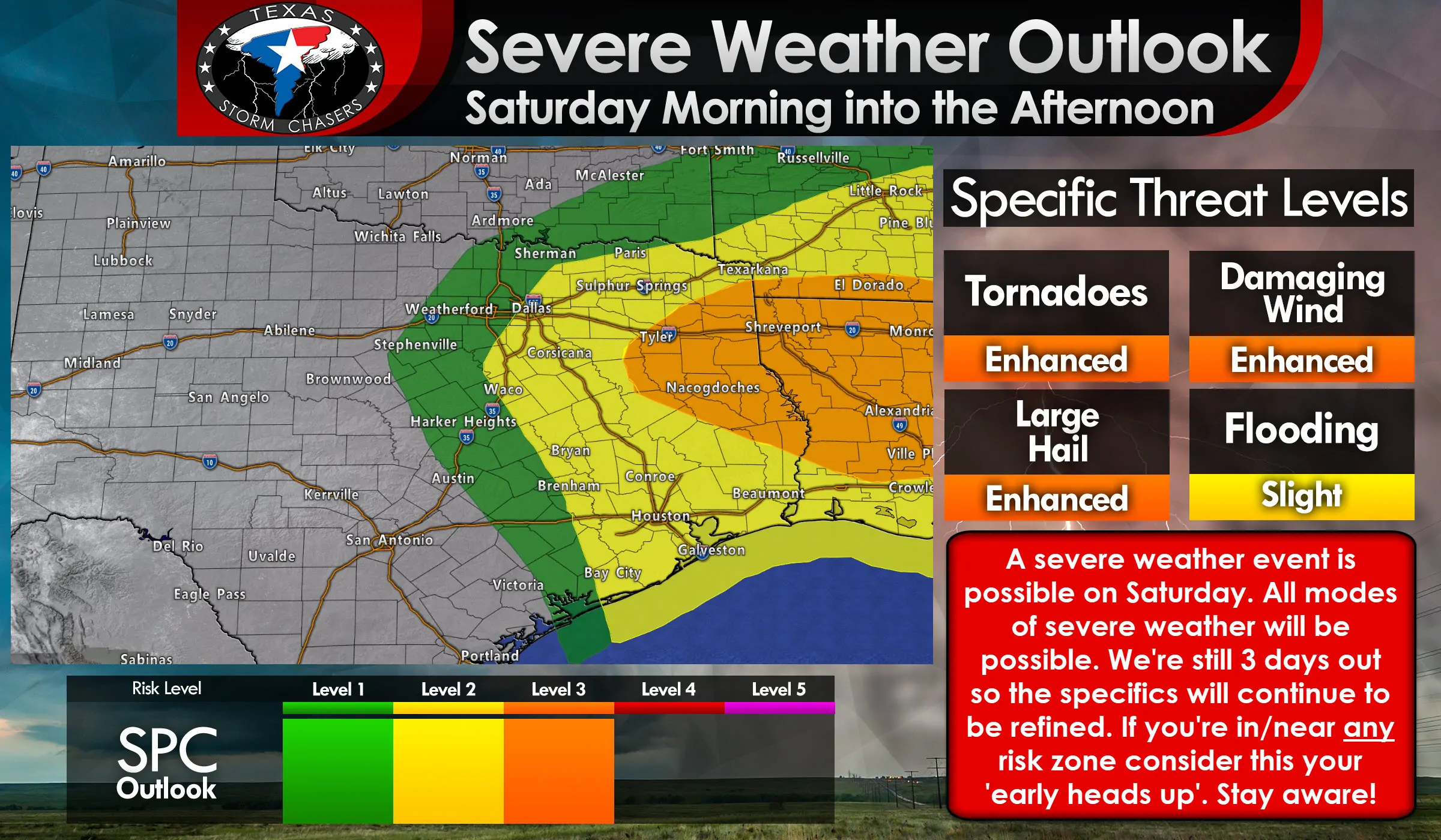
An enhanced risk of severe weather, a level 3 risk, is now in place for Saturday morning and Saturday afternoon across a good chunk of East Texas. The standard level 2 risk includes Southeast Texas, the Brazos Valley, the eastern half of North Texas, and Northeast Texas. Keep in mind that storms late Friday night and early Saturday are *not* included in this risk zone (we talked about that threat in the first paragraph). This outlook is for the daytime storms on Saturday.
All modes of severe weather will be possible with the strongest storms from mid-morning Saturday through the mid-afternoon hours. The strongest storms should move east into Lousiana by the mid-afternoon. As that occurs we’ll see our low-level wind shear quickly weaken and become unidirectional. That means if we’re still dealing with storms by late Saturday afternoon into Saturday evening they’d mainly be a hail/wind threat compared to the mid-morning/early afternoon storms. Those could feature a threat of tornadoes.
The highest threat of tornadoes will be along and south of that warm front Saturday morning and early Saturday afternoon. If the front is kept farther south by widespread storms across North Texas Saturday morning then hail and strong winds would be the primary severe weather threat, although a low threat of tornadoes would exist.
If the warm front is able to make it north toward Interstate 20 – and storms were able to actually thrive in the unstable/strongly-sheared airmass – we’d be talking about a threat of damaging winds, large hail, and several tornadoes. Low-level wind shear and projected instability values are going to be very supportive of tornadic supercells (if that airmass came to fruition). That’s why we already have a level 3 risk of severe weather in place and why we need to closely watch this setup. It’s not written in stone, but the potential is there.
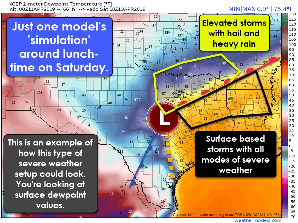
We also have a concern that a weak cap means storms may be able to fire up well ahead of the dryline by mid/late Saturday morning across East Texas. Those storms firing up in the open warm-sector would be the ones we’d have to watch carefully for a tornado risk. Of course, that would present a challenge on narrowing down a specific time window for the highest threat.
If the cap is too weak and we see numerous storms fire up at once that would tend to make it difficult for individual storms to organize. They would be fighting each other (interfering) versus having the airmass to themselves. These are the details we’ll have to work out in the coming days. So if we had a bunch of storms in a small area that would tend to actually keep the severe weather comparatively lower since storms wouldn’t be able to actually ‘dominate’ the local airmass.
Just how much of a tornado threat we have to deal with Saturday morning into early Saturday afternoon in Texas will depend on how far north the warm front can go and whether or not we have more isolated/semi-discrete storms versus a big, messy blob. That blob would still have a hail/wind threat, but the isolated/semi-discrete mode could result in a significant severe weather threat. We’ll get more data in beginning tonight that should help us provide more specifics.
The highest threat of severe weather should be moving east of Texas by the late afternoon. However, I can’t rule out storms continuing across eastern North Texas, Northeast Texas, East Texas, and in Southeast Texas through the evening hours. Low-level wind shear values will be less favorable for tornadoes, but the atmosphere would still be supportive of hail and damaging winds.
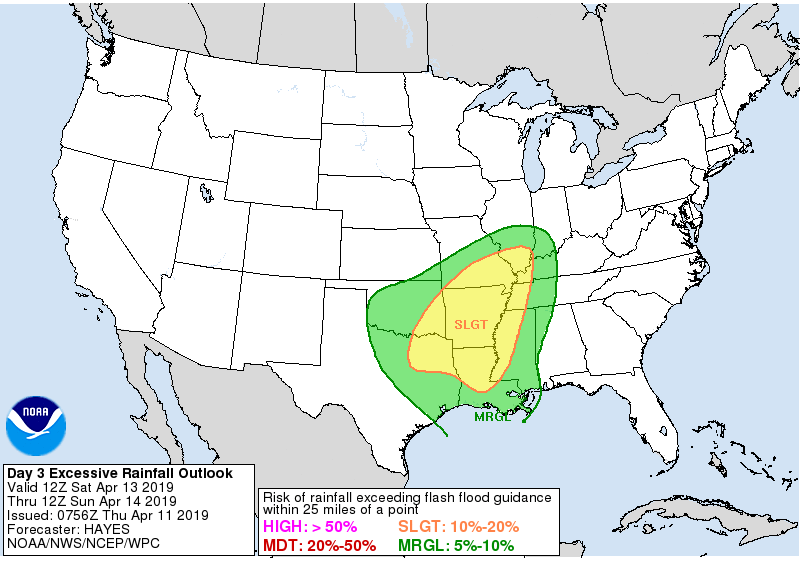
Saturday’s flash flood outlook
Not to be left out we’re also worried about a flooding threat on Saturday. Widespread thunderstorms are expected in the proximity of and north of the warm front. Moisture values will be highly supportive of heavy rainfall. Some weather models are producing 4 to 6 inches of rain across Northeast Texas. Those rain totals would result in areas of flash flooding (immediate threat) and stream/river flooding (in the following days). I wouldn’t be surprised if a flash flood watch is eventually required.


0 Comments