
I’ll forgo talking too much about current weather given that it will be different by the time you read this. We’re monitoring a tornadic supercell approaching Hondo in South-Central Texas. This supercell is moving east toward Bexar County and the San Antonio metro. It’ll arrive in the western part of Bexar county after 9 AM assuming it does not shift direction and/or weaken. A line of strong storms is moving eastward across the eastern Concho Valley and in the Edwards Plateau. Those storms will continue to move east and could have locally damaging winds, hail, and perhaps brief tornadoes. We’ll be watching to see if it remains a ‘line’ or starts to break up into semi-discrete storms. New storms are firing up across Central Texas and those will move north into North Texas with a risk of hail.
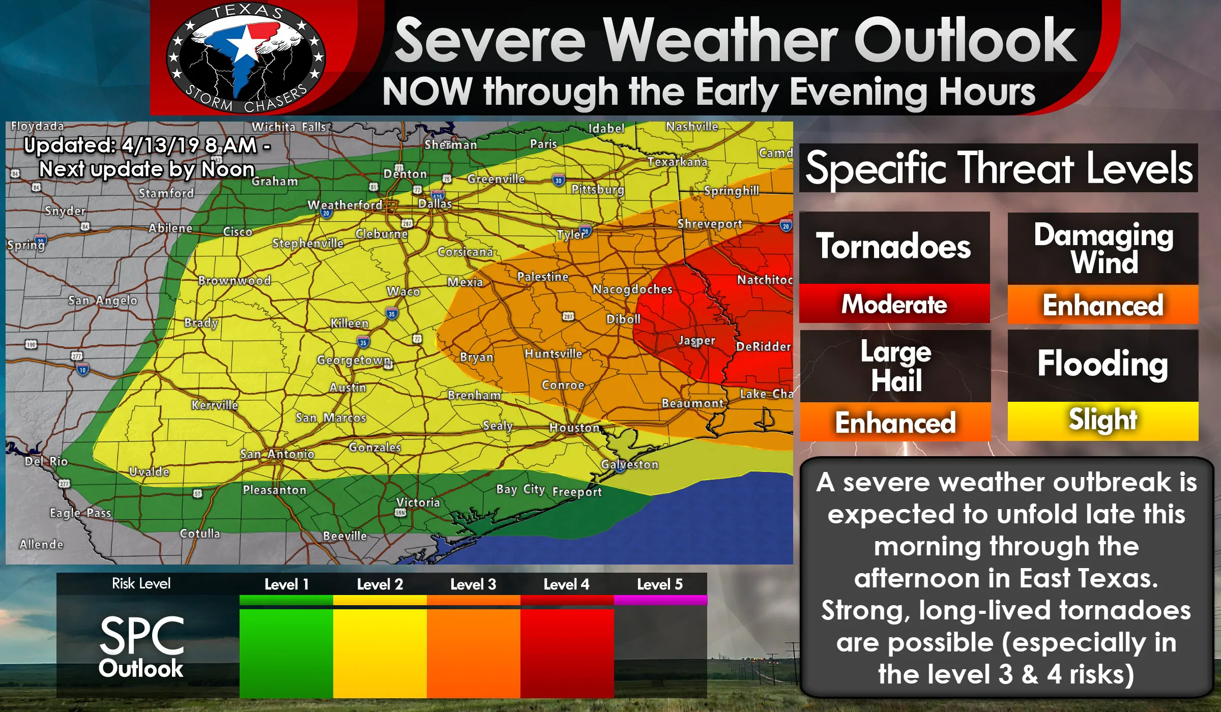
A level 2 risk of severe weather is in place for much of North Texas, the Hill Country, Northeast Texas, Central Texas, and the immediate coastline of Southeast Texas (including Houston and Harris County). A level 3 risk of severe weather is now in place for much of the Brazos Valley, Southeast Texas, and East Texas. This is the zone where we start becoming more concerned about tornadic supercells later this morning and especially by the early afternoon. A level 4 risk of severe weather is in place for far East Texas into Lousiana and Mississippi. A tornado outbreak is expected to unfold in those regions this afternoon and evening. We note that tornadoes are possible with the storms farther west in the level 2 risk as well, but the chance of stronger tornadoes increases in the level 3 and 4 risk zones (more about that below). Regardless of which risk zone you may be located in, if you’re in a risk zone, pay attention to the weather today. Very large hail up to (or possibly exceeding in some cases) the size of baseballs and wind gusts over 70 MPH are probable with the most intense storms today, in addition to the tornado risk.
Storms in the Concho Valley have likely produced at least two brief tornadoes over the last hour east of San Angelo. I honestly didn’t expect that as the warm front is still a bit to the south. However, the kinematics (wind shear) were able to overcome the less favorable thermodynamics (lack of surface-based instability and a cap). That does concern me because ingredients will only become more favorable as storms move east this morning. Storms on the southern end of the squall line in the Concho Valley will continue to have a tornado threat as they move east into the Hill Country and Central Texas in the coming hours. Storms on the northern end of the line will continue to present a risk of hail and gusty winds as they make their way toward North Texas.
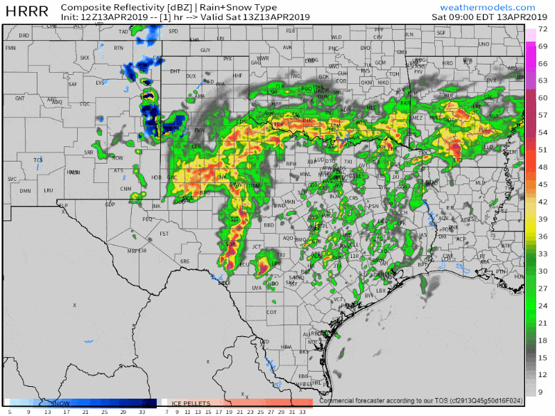
12Z HRRR simulated weather radar from 8 AM until the evening hours. This is only a simulation and should be used as such – real-life may end up looking different.
New thunderstorms are expected to develop by late-morning across southeastern North Texas, Central Texas, the Brazos Valley, into East Texas and Southeast Texas. Any storms south of the warm front, in a very unstable airmass, will be in an environment supportive of tornadoes. Again, a strong tornado cannot be ruled out if we get everything to come together. Very large hail up to the size of baseballs and localized wind gusts over 70 MPH are also likely with the strongest storms.
Storms north of the warm front will be capable of producing large to very large hail, but with a much lower tornado risk. Exactly where that warm front ends up – and how far north it can get – will determine the exact corridor of highest tornado potential by lunch-time and into the mid-afternoon hours.
The most intense severe storms should move east into Lousiana by the late afternoon or early evening hours. Wrap-around moisture will allow for showers and thunderstorms to continue into the evening across Texoma and North Texas. The risk of severe weather will be lower, but some hailers will remain possible.
Today has the potential to be a dangerous day across East Texas, with an even higher risk of a tornado outbreak in Lousiana and Mississippi. It’ll be a close call on whether or not we end up being the ‘starting point’ for that tornado outbreak or if we can get lucky and get those storms out of here before they start dropping big tornadoes. Data over the last several hours indicates we’re trending toward having a very busy afternoon across the Brazos Valley and East Texas. Regardless, take all weather warnings seriously today and ensure you’re ready to go if you have dangerous weather approach.
Click here for tornado safety tips
Click here for free HD interactive weather radar
Keep up with our weather information by downloading our free mobile app onto your smartphone. Just click the banner at the top or bottom of this page.


0 Comments