
I want to start out by sharing a resource for those experiencing storm stress and anxiety. You might be surprised to know that I personally deal with it when severe weather is threatening my home. Yup, the dude who chases tornadoes was scared beyond belief as a child of storms – and I still deal with that anxiety at times as an adult. It’s a real issue and don’t let anyone tell you otherwise. There are things you can do to empower yourself and take more control over your weather fears. The National Weather Service has put together a great page here. I encourage you to check it out.
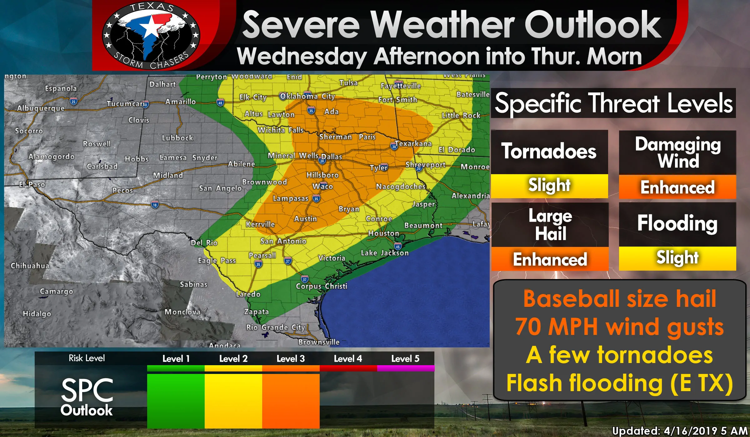
It is always a good idea to start off with the latest severe weather outlook. These outlooks are issued by the Storm Prediction Center – the national office in charge of issuing severe weather watches and outlooks. You’ll find that most television stations in Texas use the same outlook, although it may have different colors and names. Some private companies have their own indices that go from 1 to 10 or use some : CON scale. Those are marketing ploys and we don’t have time for that nonsense. Here’s the outlook from some of the best severe weather meteorologists in the world.
Click the image above for a full-screen/high resolution version.
A level 1 marginal risk of severe storms include the northeastern half of the Texas Panhandle, the eastern Big Country, the eastern Concho Valley, South Texas, the Coastal Plains, and Southeast Texas. Isolated strong to severe storms are possible in and near this risk area. Dumas, Spearman, Childress, Breckenridge, Brownwood, Laredo, Corpus Christi, Victoria, Houston, Galveston, and Jasper are a few towns included.
A level 2 risk – the standard severe weather risk level – includes the far eastern Texas Panhandle, portions of Northwest Texas, western North Texas, South-Central Texas, the Edwards Plateau, the southern Brazos Valley, and the piney woods of East Texas. Scattered severe storms are possible. Canadian, Shamrock, Wichita Falls, Graham, Del Rio, San Antonio, La Grange, Conroe, and Lufkin are a few towns included.
A level 3 risk – an enhanced severe weather risk – includes Texoma, North Texas, Northeast Texas, portions of East Texas, Central Texas, and a good chunk of the Hill Country. Numerous severe storms are possible. Gainesville, Sherman, Paris, all of the D/FW Metroplex, Hillsboro, Waco, Temple, Georgetown, Burnet, Fredricksburg, Austin, Bryan, Centerville, Fairfield, Corsicana, Palestine, Canton, Tyler, Longview, Sulphur Springs, Quitman, Gilmer, and Texarkana are a few towns included.
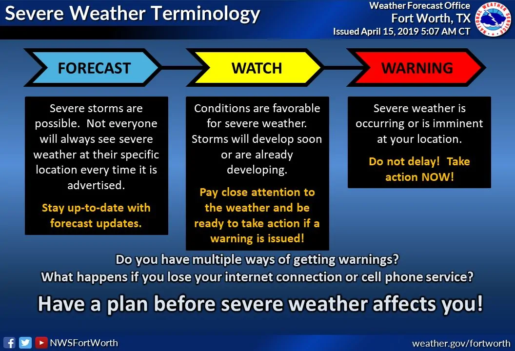
If you’re in or near any of the risk zones you should check back for the latest forecast tonight before bed. Know how you’ll get weather warnings tomorrow afternoon, tomorrow evening, overnight Wednesday, and into the morning hours on Thursday. We’re in the forecast part of the timeline.
Here are several regional maps showing the same severe weather outlook as shown at the top of the page. Several folks mentioned to me yesterday that they had issues finding their location on our state-wide graphics. While I’ve increased the number of cities displayed on our in-house graphics system, I’ll also include these auto-generated regional graphics too.
Specific severe weather threats with the strongest storms
The most common hazard tomorrow afternoon into tomorrow evening will be very large to downright giant hail. Baseball size hail or larger is probable with the strongest storms. Not all storms will produce hail that large, but tomorrow’s severe weather setup is very favorable for destructive hail storms. I can’t rule out softball or grapefruit size hail.
Damaging straight-line winds will become an increasing threat as storms grow upscale into a squall line during the evening and overnight hours. That squall line will move east across a majority of the risk zone, moving east of Texas by Thursday morning. Not all storms in that squall line will be severe.
A few tornadoes are expected. At this point, it looks like the ‘low-end’ threat is winning out, but we’ll have to keep a very close eye on the data. This does not look like a repeat of Saturday where we had long-track/significant tornadoes. Low-level wind shear values are weaker. That said – if there is one tornado tomorrow and it ends up coming down your street – it is a huge deal and ‘your’ tornado outbreak. I can’t rule out the tornado threat increasing in future outlooks, but there are a few different factors working against a higher-end tornado risk.
Timing and more specific details
There will be a lot of words and not many illustrations here. My apologies, but I find it best not to share any simulated weather model data until we’re confident in the output they’re showing. Yours truly also doesn’t have the skill-set to custom-draw fancy weather maps with storms on them. My drawings as a kid had arms coming out of heads, so I think I’ll forgo that traumatizing experience this morning.
This aspect of the forecast has become a bit more complicated since our detailed post last evening. Let me explain that. We still anticipate isolated to scattered thunderstorms to develop just east of the dryline by the late afternoon or early evening hours. Those storms would move east/northeast, eventually growing upscale into a squall line. That squall line would expand south – and a nearly solid line of thunderstorms would move east across the eastern half of Texas tomorrow night into Thursday morning.
What is a new element to the forecast is the potential of discrete thunderstorm development well east of the dryline tomorrow afternoon in Northeast Texas and East Texas. A very unstable, moisture-rich airmass will be in place. The cap will be pretty weak and it wouldn’t take much lift to generate thunderstorms. Without a distinct focal point for storm development, like the dryline farther west, I can’t say for sure if we’ll actually get storms to fire up.
If those storms do develop they’ll literally pop up in random locations in the aforementioned regions. That makes providing a specific timeline difficult. If discrete storms pop up tomorrow afternoon in Northeast and East Texas the atmosphere will be strongly supportive of supercells with all modes of severe weather possible, including some risk for tornadoes.
That threat is conditional on storms actually developing in the first place. If no development occurs the threat of severe weather will not arrive in East Texas until much later in the evening and overnight hours.
I only mention it now because I don’t folks to get surprised if we do have an earlier round of storms fire up. We’re going to watch this potential scenario closely and we will be able to provide better insight in this evening’s blog update. Storms would generally move to the northeast at 30 to 40 MPH.
The initial storms across western North Texas late tomorrow afternoon and early evening will be supercells. Those storms could produce extremely large hail and localized damaging wind gusts. A low-end tornado threat may exist. Storms will generally move to the east/northeast. By mid-evening thunderstorms be growing upscale into a squall line or cluster.
That line/cluster may still have embedded supercells with very large hail, damaging winds, and a low-end tornado threat. Those storms will likely impact the D/FW Metroplex sometime tomorrow evening. More isolated, yet still nasty hailers, are expected south along the dryline into the Hill Country and Edwards Plateau late Wednesday afternoon.
A squall line should form fairly quickly by mid-evening and we’ll see a broken line of thunderstorms from Laredo north into Oklahoma. That line will move east overnight Wednesday and into the morning hours on Thursday. The highest coverage of storms is expected within the level 2 and level 3 risk zones.
Damaging straight-line winds and quarter to golfball size hail will be the primary threats with the strongest storms in that line. Brief tornadoes are also possible, likely in conjunction with enhanced straight-line winds. That threat will continue until the line of storms exits Texas to the east sometime Thursday morning.
Flash Flooding Threat Wednesday Night & Thursday Morning
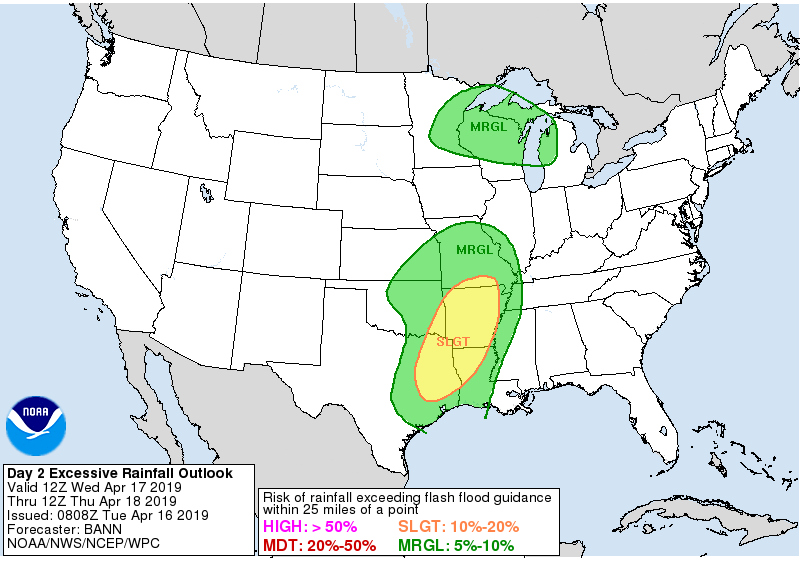
Flash flooding will be a threat Wednesday night and Thursday morning across Northeast Texas, East Texas, and far Southeast Texas. These regions have the most saturated soils from recent storms. This upcoming round of storms could produce rain amounts between 1 and 3 inches with locally higher amounts. We expect a new round of stream, river, and lake rises – generally along and east of Interstate 45.
We’ll have another detailed post published by this evening, sooner of the forecast necessitates. Take the time now while the weather is nice to review a severe weather safety plan with your family. We’ve got a full page of tips and information available here.


0 Comments