
The next several days will feature a complex and low-confidence forecast. A very slow moving upper-level low over the southwestern United States, a sub-tropical jet stream originating from Mexico, along with the position of outflow boundaries. Compared to yesterday we’ve seen the upper-level low slow its eastward progression. That allows for a somewhat higher chance of some severe weather this afternoon and evening. The sub-tropical jet originating from Mexico and the eastern Pacific is not well-sampled by an upper-air network in Mexico. With little data coming in we simply have to ‘guess’ on several parameters.
Similar situations earlier this year resulted in significant forecast changes right as events were beginning. Finally, and just because who doesn’t enjoy making forecasts even more complicated, where outflow boundaries set up could enhance or reduce severe weather chances. In summary: what you read this morning will probably change (perhaps only by a little, perhaps by a lot) by this afternoon and into tomorrow. Oh yeah, we can’t forget about the cap! Anyway, let’s dive into it.
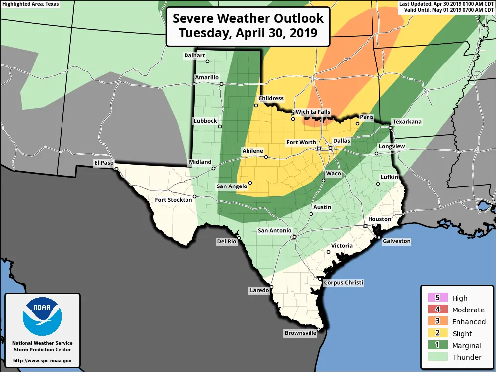
Click image for full-screen resolution
A level 2 risk – the standard risk level – includes Northwest Texas, the Big Country, Concho Valley, Texoma, and North Texas. A level 1 marginal risk includes the eastern half of the Texas Panhandle, West Texas, the Hill Country, and Northeast Texas. We do note that we have a small portion of the enhanced level 3 risk including the immediate Red River from St. Jo east to Whitesboro. Chances of having severe weather nearby are higher in the higher risk zones.
Storms that develop this afternoon and evening could produce very large hail. Much like the storms in the Permian Basin yesterday those today could produce hail up to the size of baseballs. Localized damaging wind gusts up to 70 MPH are also possible, especially if we see any storm clusters or line segments develop in the evening hours. A tornado threat may exist with storms across Oklahoma and North Texas this afternoon and early evening.
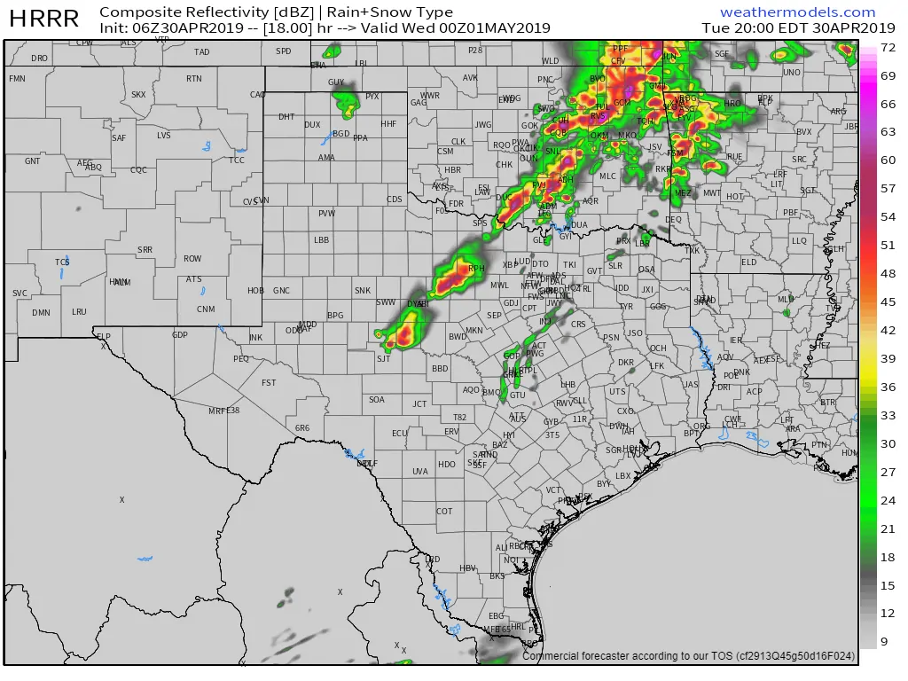
One high-resolution weather model’s depiction of how the radar may look at 7 PM today. Given the abundant uncertainty on placement of several important features, I expect the radar will probably look different. It’ll be a good couple of days to keep an eye on your preferred weather radar app.
As my rather long introduction explained, we’re expecting some forecast changes, especially as we get into the day and start moving into a ‘nowcast’ mode. A stronger cap would result in lower thunderstorm chances. A weaker cap means more severe storms if other factors were to come together. Initial storms this afternoon into the early evening hours will probably be supercelluar. As storms grow upscale this evening we could see them continue moving east with some damaging wind risk. Heavy rainfall and isolated flash flooding will be threats today, tonight, and on Wednesday.
Click image for full-screen resolution
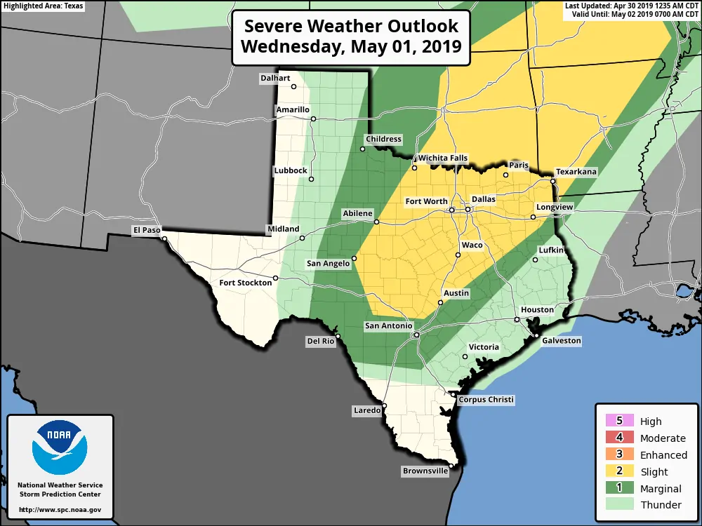
I’ll be honest here when I say the forecast for today is difficult enough. Tomorrow’s forecast will depend on what happens today – and where ‘features’ or ingredients set up shop tomorrow. A level 2 risk includes the Hill Country, Central Texas, North Texas, and Northeast Texas. A level 1 risk of severe weather includes Northwest Texas, the Big Country, Concho Valley, Edwards Plateau, into parts of the Brazos Valley. Stronger storms may produce hail and localized damaging wind gusts. Heavy rainfall from stronger storms may produce localized flash flooding. Isolated tornadoes may be a threat, but the extent of each specific severe weather hazard will depend on how everything comes together.
We could see some portions of the outlook upgraded in future outlooks if confidence in a squall line (damaging wind/hail threat) increases for tomorrow and tomorrow night. If we see those heavy storms over areas that have experienced heavy rains over the last several weeks we’d also see a flooding threat. We’ll provide a more detailed forecast for Wednesday tonight (assuming I’m not chasing tornadoes near my home in Oklahoma).
Storms will remain possible (if not probable) across the southeastern half of Texas on Thursday. Ingredients don’t look to support as high of a potential severe weather threat as today and Wednesday, but some stronger storms will be possible. Heavy rainfall and flooding could be the main story by that point.


0 Comments