
The Storm Prediction Center has issued a Tornado WATCH for much of southeast Texas through 7pm this evening. Counties included in the watch: Angelina, Brazos, Cherokee, Grimes, Hardin, Houston, Jasper, Liberty, Madison, Montgomery, Nacogdoches, Newton, Panola, Polk, Rusk, Sabine, San Augustine, San Jacinto, Shelby, Trinity, Tyler and Walker.

The environment across this region will continue to become more favorable for scattered severe storm development into the afternoon hours as a warm front continues to drift north. Large hail 2.5 inches or larger, damaging winds and tornadoes…a few possibly intense tornadoes…are possible as we move into the afternoon hours. As we’re already seeing across central Texas, the atmosphere is primed for severe weather. This threat will continue to increase through the afternoon hours, so residents within and near the WATCH area will need to pay close attention to weather conditions present near their location. Monitor local media today…have your weather radio operational…have a way to receive warnings and seek shelter immediately if any are issued.
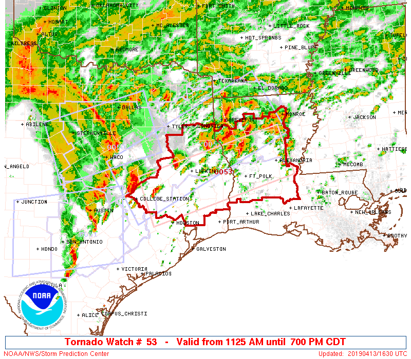
NWS Storm Prediction Center Norman OK
   1125 AM CDT Sat Apr 13 2019

   The NWS Storm Prediction Center has issued a

   * Tornado Watch for portions of
     Northern and central Louisiana
     Eastern Texas

   * Effective this Saturday morning and evening from 1125 AM until
     700 PM CDT.

   * Primary threats include...
     A few tornadoes and a couple intense tornadoes likely
     Scattered large hail and isolated very large hail events to 2.5
       inches in diameter likely
     Scattered damaging winds likely with isolated significant gusts
       to 75 mph possible

   SUMMARY...Discrete supercells and clusters should continue to
   develop near a west-east oriented warm front that is advancing
   north. All hazards are expected throughout the afternoon.


0 Comments