
Does anyone else miss winter and snow potential yet? Well, we’ll have to see what next weekend holds. We’re only in the first week of April and already we’re looking at several days of severe weather potential across Texas. Not only will we have to deal with the threat of severe storms, but there are going to be multiple rounds. Each round could leave boundaries and alter the ‘playing field’ for the next round. All that makes for a difficult forecast and havoc in the land of weather models.
Please understand that it’s easy enough for your crap weather app to say a high chance of rain/storms tonight, Saturday, and on Sunday. A kid in elementary school could make that forecast for this weekend. Forecasting specific severe weather risks and potential areas of localized enhancement is difficult enough for one event. Doing so for four or five rounds in 72 hours? Yeah, that’s where experience and some understanding of severe convection come into play.
There will be changes to the forecast in the coming days. We’ll focus on one round at a time (outside of a general overview included in this blog) and once that round ends, we can focus on the next one. Heavy rainfall and the threat of minor flooding will also be a hazard, especially by Sunday east of Interstate 45.
Today and Tonight
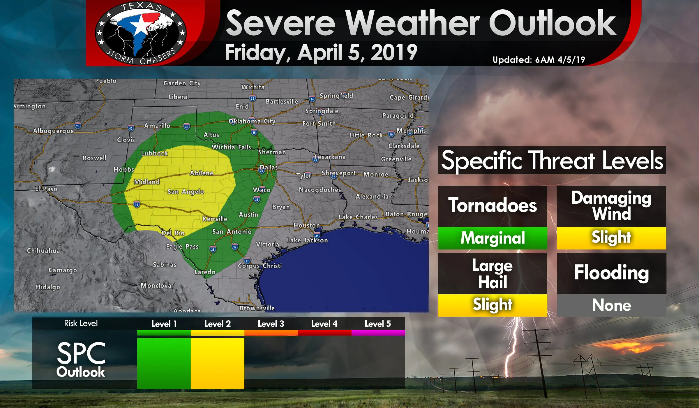
A level 2 risk, the standard risk level, of severe weather is in place for West Texas, the Permian Basin, Big Country, Concho Valley, and portions of the Edwards Plateau and Hill Country. A level 1 risk includes the southeastern Texas Panhandle, Northwest Texas, Texoma, North Texas, Central Texas, South-Central Texas, and portions of South Texas. These risk levels are based on the probability of experiencing severe weather within 25 miles of your given point. The higher the level the higher the chance. For specific probabilities correlated to risk levels head over to our severe weather guide here.
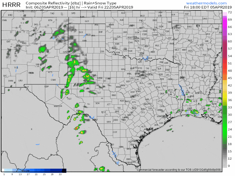
06Z HRRR Simulated Weather Radar from 5 PM this afternoon until 10 AM Saturday morning. This is only a simulation and meant to convey a general timeline…
Isolated to widely scattered storms will likely fire up by 5 PM east of a dryline in the Permian Basin and West Texas. Dewpoint values (a way of measuring available moisture for severe storms) will only be in the 40s to lower 50s. That’s not particularly impressive and is a sign that cloud bases will be high. High cloud bases mean the threat of tornadoes will remain very low. Instability values aloft will be supportive of a few severe storms with golfball size hail and localized damaging winds up to 70 MPH. Those storms will move northeast toward Northwest Texas this evening while generally weakening.
Additional thunderstorms are expected to form late this evening, perhaps closer to midnight or after, across West Texas and the Permian Basin as stronger lift arrives with an upper-level storm system. These storms will likely grow upscale into a cluster or squall line by early Saturday. Those storms will also move northeast toward Northwest Texas and eventually move into Southwestern/Southern Oklahoma. Large hail and eventually a risk of damaging straight-line winds are expected with the strongest storms. They’ll slowly weaken Saturday morning as they move east toward Interstate 35 in Oklahoma and the Red River Valley.
Potential Alternatives: It’s possible the weather model shown here is underestimating the squall line’s strength. If that’s the case the line of storms may actually be far more expansive than shown – going from the Edwards Plateau northward into Oklahoma. That would result in a west to east squall line impacting many more regions, including I-35, by Saturday morning into Saturday afternoon with a threat of damaging straight-line winds, hail, and brief tornadoes.
Saturday
A level 2 risk of severe weather, the standard risk level, essentially includes the eastern half of Texas. Portions of that spatially large risk area may be upgraded in later updates as confidence increases on a particular forecast solution. This is where we start dealing with uncertainties given two rounds of storms Friday night into Saturday morning.
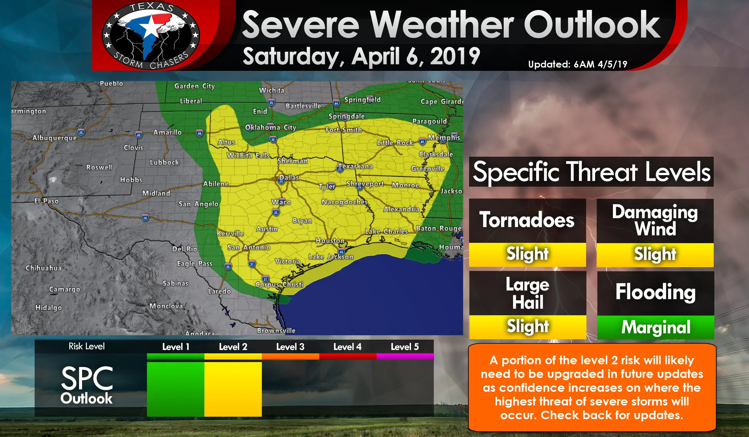
Storms should be underway Saturday morning across Northwest Texas as discussed above. Those storms should move northeast into Oklahoma with portions of the Red River Valley also possibly seeing storms. If the alternative solution, also discussed above, comes to fruition then the day will be occupied a squall line or thunderstorm cluster moving west to east Saturday morning and Saturday afternoon.
If the storms Friday night and Saturday morning end up moving more into Oklahoma and the Red River Valley we may see scattered storms fire up across North Texas, Central Texas, and the Hill Country by the early afternoon hours. Some of those storms would likely become severe with a threat of hail up to the size of golf balls, localized damaging winds up to 65 MPH, and at least a low threat of isolated tornadoes. Those storms would move northeast through the afternoon hours – with a ‘messy’ storm mode involving a mix of supercelluar storm structures and small storm clusters moving into Northeast Texas, East Texas, and the Brazos Valley.
Both the ‘west to east squall line’ and ‘afternoon scattered storms’ solutions would result in a risk of severe weather. I detailed both since a weakly capped environment like the one expected tomorrow makes for a more difficult forecast (its easier to get storms to fire up, versus a comparatively stronger cap that would focus storm development). Once weather models start being more agreeable on a particular solution we’ll be able to provide a more specific timeline along with information on the risk level of each particular severe weather hazard.
Saturday afternoon/evening back west along the dryline
If all that wasn’t enough fun – the dryline itself is still expected to be back in the eastern Texas Panhandle to West-Central Texas Saturday afternoon. Assuming there are a few hours of clearing that allows for the atmosphere to destabilize we’d see isolated to widely scattered supercell storms fire up in the late afternoon. Those storms would be capable of producing very large hail, localized damaging wind gusts, and isolated tornadoes as they moved east/northeast toward the Big Country and western North Texas. This is a more conditional threat and one that we’ll discuss further if it becomes more likely (we have to get past tonight’s storms first).
Sunday
A level 2 risk of severe weather is in place along and east of Interstate 35W and Interstate 35 from Pauls Valley, Oklahoma south to Austin to Victoria – and points east by several hundred miles. It’s another large risk zone that’ll probably see smaller areas of upgrades in later updates.
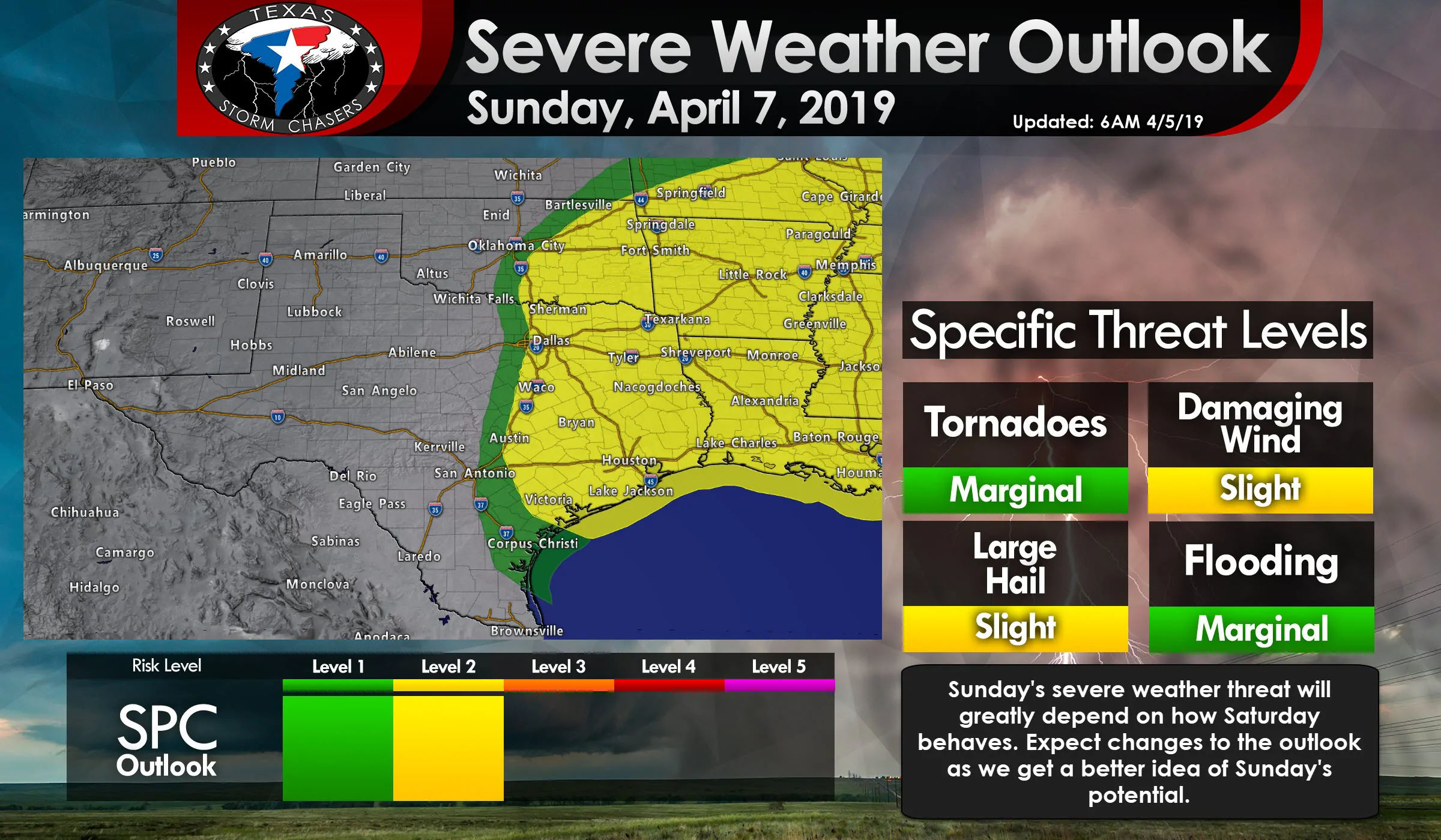
Sunday’s forecast will greatly depend on how the atmosphere recovers from Saturday’s storms. Some data tonight suggests that an extremely unstable airmass will develop east of the dryline (located on the western edge of the risk) by Sunday afternoon. Isolated to widely scattered severe storms with a threat of very large hail, localized damaging winds, and isolated tornadoes would develop by the late afternoon and move east if that solution panned out.
I don’t want to touch too much on Sunday at this point given the high uncertainty on how it’ll evolve. Let’s get into Saturday and hopefully, we’ll have a better idea of how Sunday will play out. I’d be ready for yet another round of active severe storms though given the potential for a very unstable airmass. If that extremely unstable airmass pans out the stage will be set for some very big hailers.
Just as likely is that all the rain/storms over the previous two days will have worked over the atmosphere. Widespread cloud cover and residual showers prevent the atmosphere from destabilizing Sunday afternoon and storms that are able to develop remain comparatively tame. This is a very low confidence forecast for Sunday since we’ve got to get past (3?+) rounds of storms first.
Summary
We’ll be watching data closely today and will have updates to our forecast blogs here on the website and in our free mobile app. Once storms get going later today we’ll begin posting more frequent updates (nowcasting) on our social media accounts. Several rounds of severe weather are probable from this afternoon through Sunday evening. Heavy rains will also result in a minor flooding threat by Sunday across the eastern third of Texas.


0 Comments