
Scattered thunderstorms continue early this evening from near Fort Stockton to Big Spring to Winters to Mineral Wells to the D/FW Metroplex. The strongest storms across the Permian Basin and Big Country have a history of producing quarter to baseball size hail along with wind gusts measured at 70 MPH. We’ve also seen copious amounts of rainfall in short periods of time with most storms today (~2-3 per hour if a storm was sitting on one spot that long). Hailers will remain a threat for the next few hours, but we should start transitioning toward a heavy rainfall and localized strong wind gust threat by mid-evening. Most storms are moving east or northeast, depending on storm-scale interactions. You can track ongoing storms with our high-definition weather radar here or in our free mobile app.
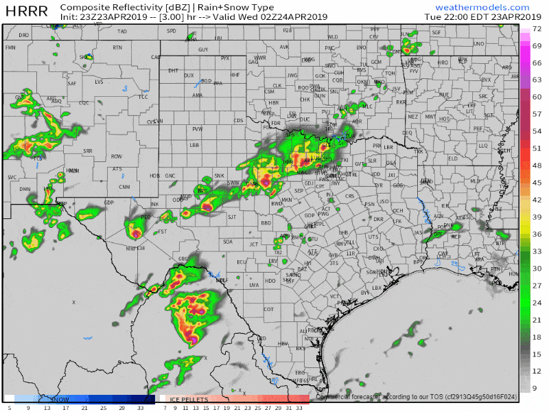
23Z HRRR: Simulated weather radar from 9 PM this evening through 11 AM Wednesday. This is only a simulation and the location of a nearly-stationary cool front will dictate where the heaviest rains set up shop tonight and into tomorrow. Storms will continue beyond this period. Click on the image for a full-screen version.
Storms ongoing from near Mineral Wells to the north of Stephenville are moving northeast around 40 MPH. They’ll likely be in the D/FW metroplex by 9 PM. While I can’t rule out small hail and gusty winds, my main concern will be the threat of some flooding. That storm could drop a quick 2-3 inches of rain in portions of the metroplex this evening. That would result in flash flooding. Be mindful of low-water crossings and the typical spots that may flood during heavy rain as the storms west of D/FW arrive over the next 2 hours.
A nearly-stationary cold front extending from the Permian Basin northeast into North Texas won’t move much overnight. Upper-level lift is increasing and we’ll likely see showers and storms continue through the overnight hours. The severe weather threat will be decreasing with time this evening. Our main worry will be the threat of localized flash flooding. Storms may ‘train’ or move over the same locations due to the stationary front and increased lift near it. Training storms can produce localized rain totals exceeding 3-5 inches over a few hours. That kind of heavy rain will be localized, but where it falls, expect flash flooding. I’m worried that a portion of this may set up over parts of the D/FW Metroplex south toward Waco and Temple – and the urban infrastructure would only exacerbate water runoff problems. Most folks won’t see flooding tonight.
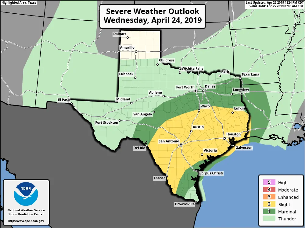
Wednesday’s Severe Weather Outlook
Thunderstorms will increase tomorrow morning as the sun helps to destabilize the atmosphere. Wind shear values, abundant amounts of moisture, and a destabilizing atmosphere will support new strong to severe storms on Wednesday. The highest chance of having a severe storm will be across the Edwards Plateau, South Texas, South-Central Texas, Central Texas, the Brazos Valley, East Texas, Southeast Texas, and the Coastal Plains. The most intense storms could produce hail up to the size of golf balls, localized wind gusts up to 70 MPH, and perhaps isolated tornadoes. Heavy rainfall and isolated flooding will also be a threat with most activity tomorrow. The activity would generally develop in the western sections of the risk zone early tomorrow afternoon and move east. Does that mean everyone will be impacted by severe storms or flooding tomorrow? Nope.


0 Comments