
I believe I was spoiled by last spring’s relatively quiet weather pattern. Sure, we had to deal with plenty of wildfire threats, but that was about it. Over the next 72 hours we’re going to have the threat of wildfires, damaging winds (non-thunderstorm related), near record high temperatures, heavy rainfall, severe storms, and the potential of snow. Boy oh boy I’m going to need to refill my cup of coffee. Luckily we’ve been around for a while and we love sharing weather information. Let’s get down to it!
It’s going to be a scorcher today!
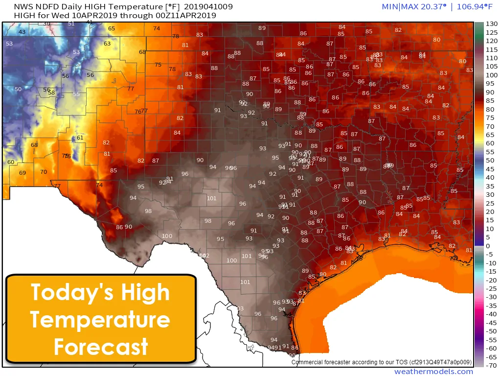
High temperatures across the state will generally make it up into the upper 80s to 90s. The unlucky folks from the Concho Valley and South-Central Texas south into the Edwards Plateau will make a run at 100 to 105 degrees this afternoon. Our usual spring hotspot of Laredo may hit 106-107 degrees this afternoon. Wichita Falls, D/FW, Abilene, Waco, Austin, and San Antonio will top out in the lower to middle 90s. San Angelo and the western suburbs of San Antonio could top out above 100 degrees. Houston will ‘only’ make it into the middle 80s, but increasing humidity will make it feel warmer. Those on the immediate coast will enjoy the seabreeze and ‘cooler’ temperatures with 70s and 80s. El Paso and the Borderland will also be ‘cooler’ than most with 70s.
But wait – there’s more! It’s WIND TIME!
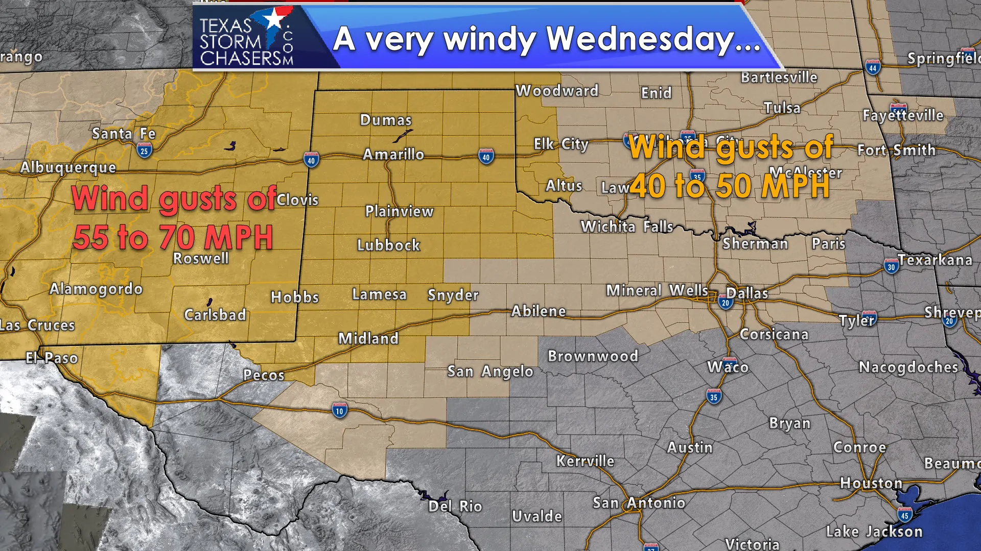
The big story today probably won’t be the annoying early summer preview, but the wind that’ll accompany it. The northwestern half of Texas will be quite windy today with gusts exceeding 40 MPH. Damaging winds of 60 to 70 MPH are expected across the Texas Panhandle, far Northwest Texas, West Texas, Permian Basin, and the Borderland. This won’t be quite a repeat of last month’s 80 MPH windstorm, but I still expect plenty of blowing dust, downed power lines, and the occasional piece of sheet metal blowing across the field. So what does above-average temperatures, very strong winds, and a post-dryline air mass get us?
DANGEROUS WILDFIRE THREAT TODAY
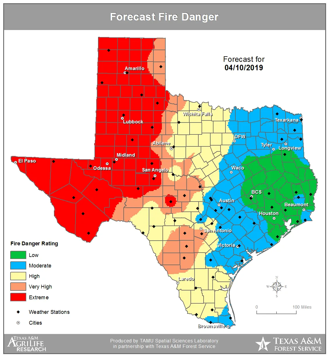
An extremely critical wildfire threat is expected today across the Borderland, Trans-Pecos, Permian Basin, West Texas, and Texas Panhandle. Very high to extreme conditions are expected in Northwest Texas, the Big Country, Concho Valley, South-Central Texas, into the Edwards Plateau. Humidity values west of a dryline (which will push east ot near I-35) will drop below 10-20 percent. Above-average temperatures and those strong west/southwest winds will also quickly dry out surface fuels. While we have seen a greenup the farther east you go, we’re going to be in a world of hurt if wildfires develop today. Considering we’re expecting downed power lines from damaging wind gusts those will likely be able to start several wildfires. This is going to be a day where we may see fires move miles per hour.
Please be extremely careful if you’re working outdoors today since even a spark or heat from outdoor equipment could prove to be enough for ignition. Know your escape routes and where you’ll go if a wildfire approaches your location. I realize most folks don’t think of the ‘ready – set – go’ wildfire plan, but you need to be set today across the western half of Texas. Fires can move faster than you can run on days with today’s weather conditions. This is the kind of day where folks can get easily overrun and killed if they’re not paying attention and a wildfire develops. We got lucky with last month’s wind event in that the threat of wildfires was fairly modest. That is not the case this time around.
Thursday and Friday look quiet, but Friday night is when that changes
A very strong upper level storm system will begin arriving into Texas Friday night. Precipitation will rapidly increase from west to east as a surface low begins intensifying over southern Texas. That low will tend to move north Saturday morning before moving more northeast and exiting Texas Saturday night. This event could feature multiple hazards including the threat of severe thunderstorms, localized flooding from heavy rainfall, and even the threat of winter weather in the Texas Panhandle.
Friday Night/Saturday morning
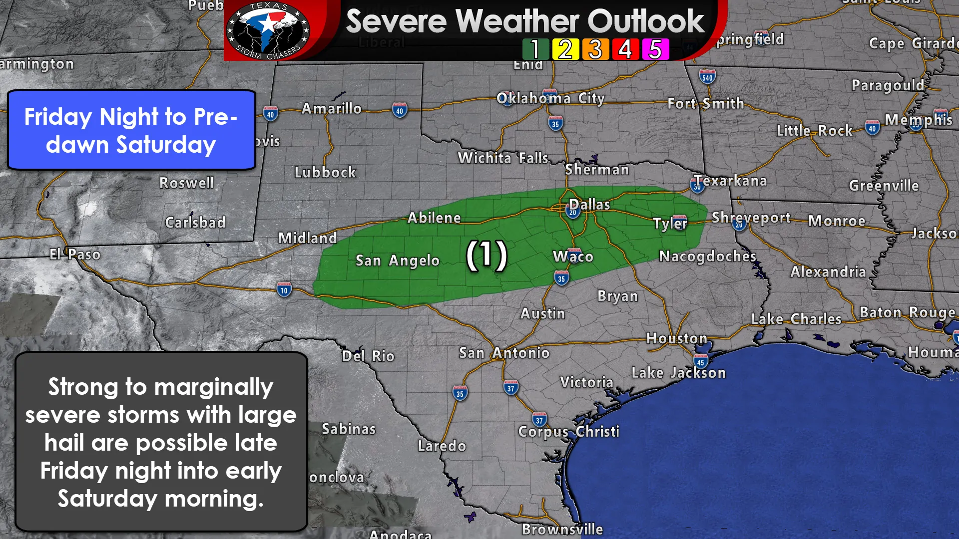
A level one risk of severe weather is in place late Friday night into the pre-dawn hours Saturday from the Big Country and Concho Valley eastward through North Texas and East Texas. We could see a few stronger storms embedded within more widespread areas of rainfall. Those stronger storms could produce lots of small hail, but marginally severe storms with quarter size hail are also possible. That threat could increase toward daybreak Saturday.
Saturday morning through much of Saturday
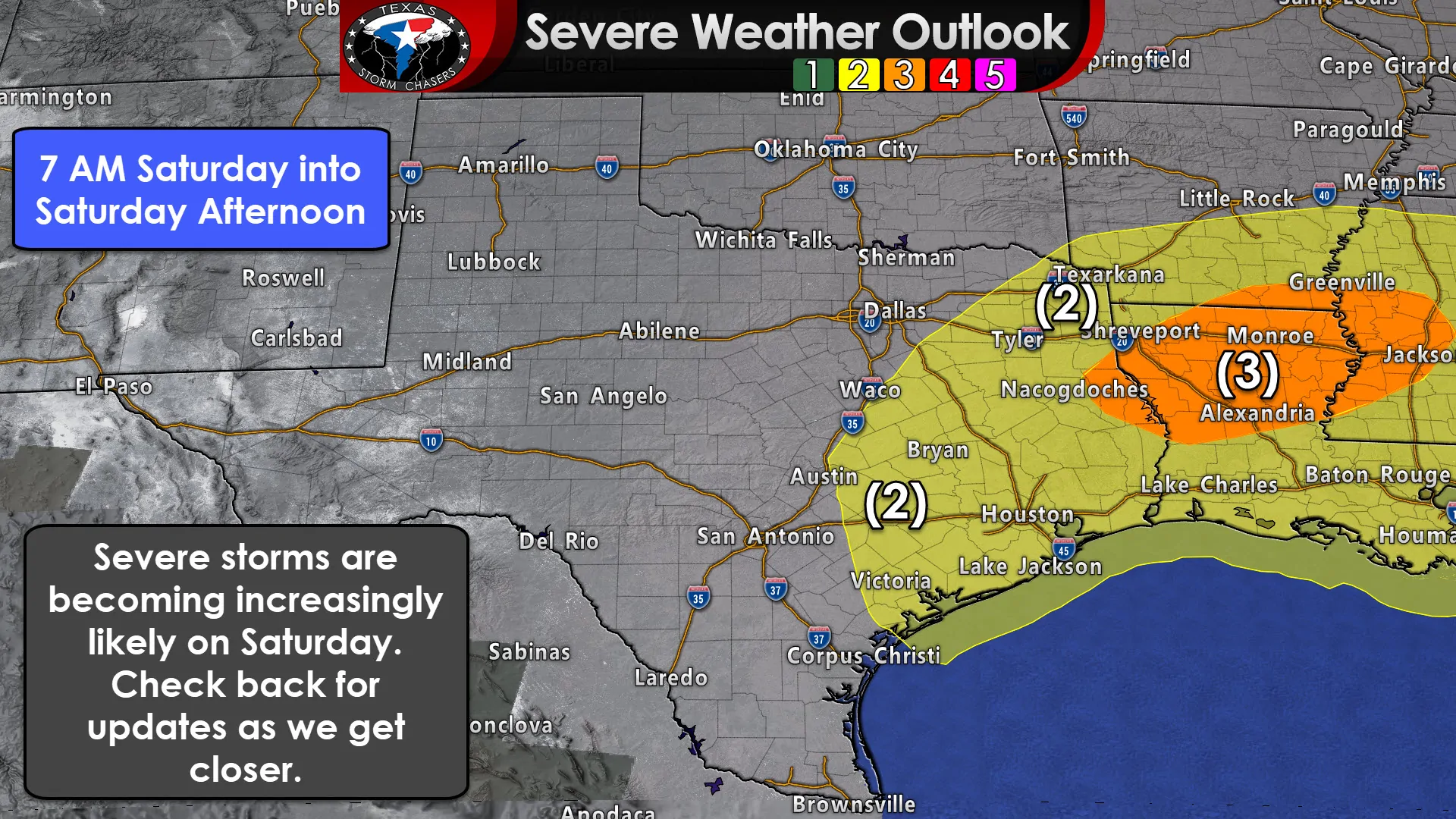
As we continue past sunrise on Saturday we’ll increase the risk of severe weather. A level two risk of severe weather, the standard risk level, is in place across Northeast Texas, East Texas, Southeast Texas, the Coastal Plains, the Brazos Valley, and portions of Central and North Texas. A level three risk of severe weather, an enhanced risk, is already in place for far East Texas and Louisiana. Having a level 3 risk in place four days out is fairly rare and indicative of an event we need to closely monitor.
We’ll need to get past today’s wild weather and get some weather balloon data into the storm system as it moves inland in the coming days before we get more specific on timing and threats. However, current data suggests that all modes of severe weather would be possible. At this point just remember to check back for forecast updates in coming days since we may be busy in the severe weather department on Saturday.
Heavy rain threat
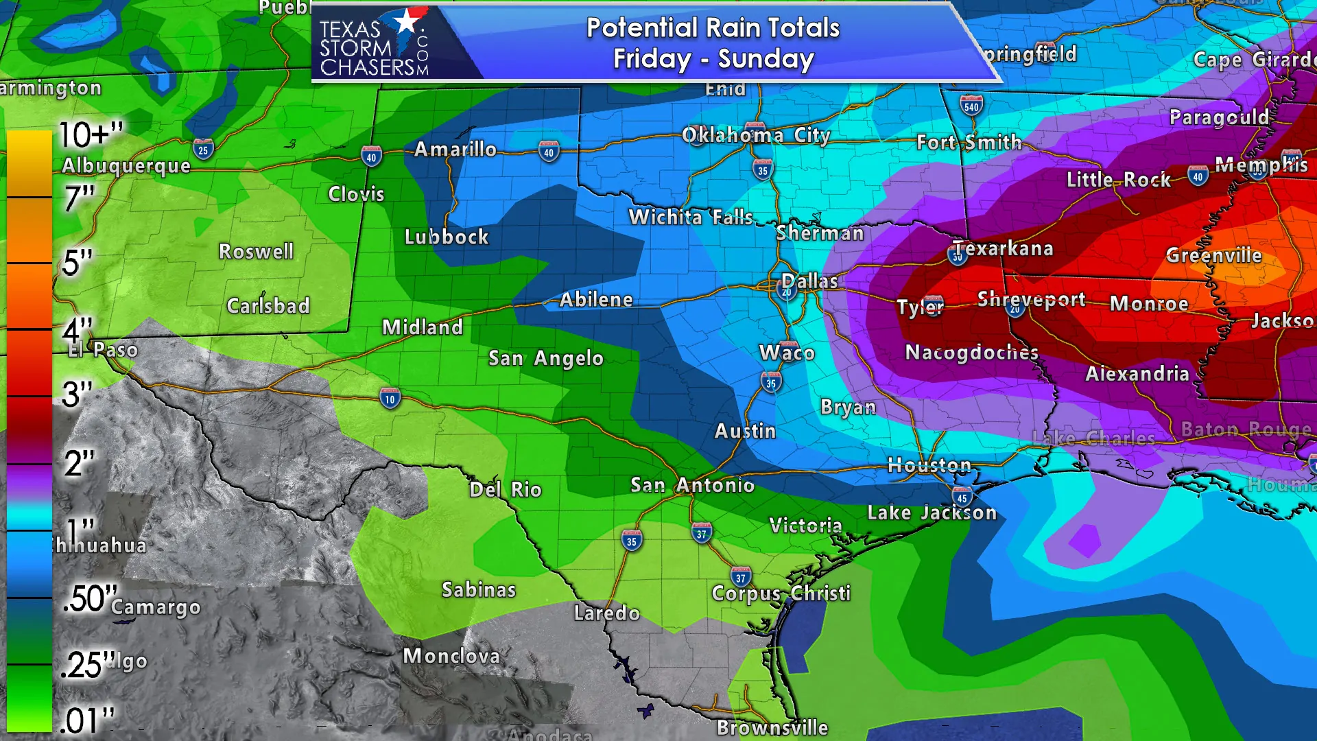
Several inches of rain is expected to fall across Northeast Texas and East Texas with our Friday-Saturday storm system. Amounts will become lighter the farther west you go, although at least an inch of rain seems probable along and east of a line from Wichita Falls to Abilene to Austin to Galveston. We’ll refine expected rain totals as we get closer (my line of the day?).
Snow in April? Yup. It’s happened before
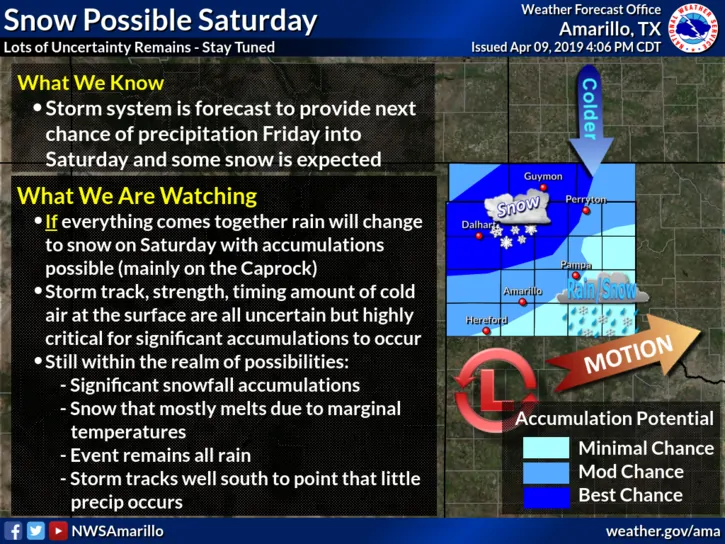
Last but not least, the Saturday system may be able to squeeze out some wet snow in the Texas Panhandle. Given that forecasting snow outside of 24 hours is difficult in Texas I’m not even going to bother trying to get more specific at this range. However, some weather model data is indicating that we’ll need to closely watch that potential as some folks may get a decent amount of snow. We haven’t passed Easter so all is fair in the world of winter!


0 Comments