
Yesterday was a weird day in the weather department. Yes, we had a risk of severe weather (which we had discussed in detail). What was not expected were two significant tornadoes generated in unusual circumstances. The Bryan tornado was produced by a shower, with no lightning, and quite an unimpressive look on the radar at around 5 PM Wednesday. The San Augustine tornado occurred later in the night at about 11:22 PM. Both tornadoes produced significant damage and injuries.
Click image for full-resolution.
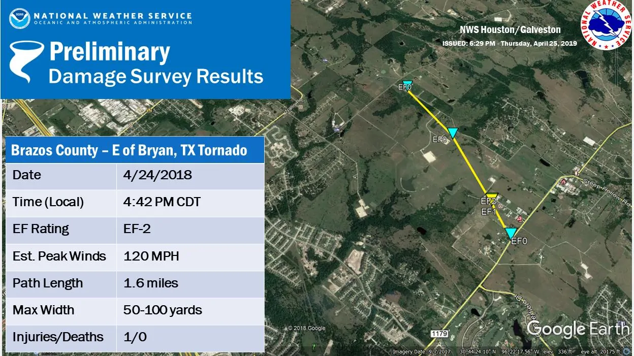
…Nws damage survey for April 24 tornado event near Bryan tx…
.Tornado east of Bryan tx…
Rating: ef-2
Estimated peak wind: 120 mph
Path length /statute/: 1.6 miles
Path width /maximum/: 50-100 yards
Fatalities: 0
Injuries: 1
Start date: april 24, 2019
Start time: 442pm cdt
Start location: fm 1179 and coyote run
Start lat/lon: 30.6871_/_-96.3018
End date: april 24, 2019
End time: 447pm cdt
End location: old reliance road and merka drive
End_lat/lon: 30.7090_/_-96.3118
Survey summary:
Damage survey found that a tornado touched down about 4 miles east of
Bryan Texas along farm to market road 1179 at around 442pm CDT causing
Damage to one house and four commercial buildings and warehouses. There
Was one injury to a male inside one of the warehouses. The tornado then
Tracked north-northwest towards another warehouse building with tree
Damage along its path before dissipating near merka drive east of old
Reliance road around 447pm cdt. Damage to the warehouses and commercial
Buildings was rated ef-2 with other damage ranging from ef-0 to ef-1.
Start time and end times of the tornado were based on eyewitness reports
And time matched with radar data.
April 24, 2019 San Augustine, TX Tornado
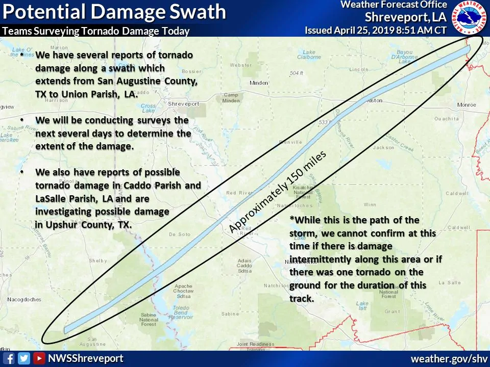
The path of the San Augustine to Ruston supercell. There was not a single tornado in progress for that entire 150 miles. There were likely several tornadoes spread out, and one was not ‘down’ for the entire 150 miles.
My personal thoughts…
The San Augustine tornado was produced in a conditionally-supportive environment for severe weather. Storms had weakened earlier in the evening farther west. They were moving east with 35-45 MPH winds, heavy rain, and lightning. I’ll be totally honest when I say they were not expected to intensify. In fact, I was on my way to the gym when I heard about the San Augustine tornado after the fact.
The National Weather Service in Shreveport and local television meteorologists saved a lot of lives last night. They were on the ball and got the warning out. I seriously thought we were going to have fatalities when I looked over weather radar data just after the fact. Tornado debris was lofted over 15,000 feet and velocity data indicated winds at around 5,000 feet ASL were over 150 MPH.
That same storm continued east/northeast into Lousiana where it continued producing tornadoes. One tornado did result in two fatalities in Ruston, Lousiana.

San Augustine Tornado Damage Survey
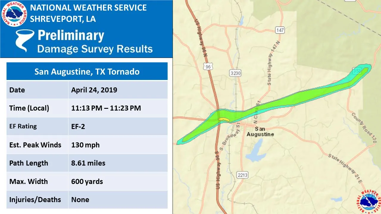
Tornado #1 – San Augustine, TX
Rating: EF2
Estimated Peak Wind: 130 mph
Path Length /statute/: 8.61 miles
Path Width /maximum/: 1100.0 yards
Fatalities: 0
Injuries: 0
Start Date: 04/24/2019
Start Time: 11:13 PM CDT
Start Location: 3 WSW San Augustine / San Augustine / TX
Start Lat/Lon: 31.5181 / -94.1543
End Date: 04/24/2019
End Time: 11:23 PM CDT
End Location: 6 ENE San Augustine / San Augustine / TX
End Lat/Lon: 31.5634 / -94.0198
Summary: The tornado first touched down along County Road
1277 where it uprooted and snapped numerous trees as it
paralleled the road. It then widened and moved across Cedar Rd
where extensive tree damage led to structural damage to
54 structures in a neighborhood. As it continued, it ripped the
awning off a gas station and snapped the the electrical
transmission tower of a sub-station near the intersection of U.S.
Route 96 and Texas Route 21. A laundromat and several additional
structures underwent extensive damage as the storm moved across
the northern side of downtown San Augustine. After pushing
through the northern part of the city, it continued to uproot and
snap trees nearby along route 353 and lifted before reaching the
Shelby County line.
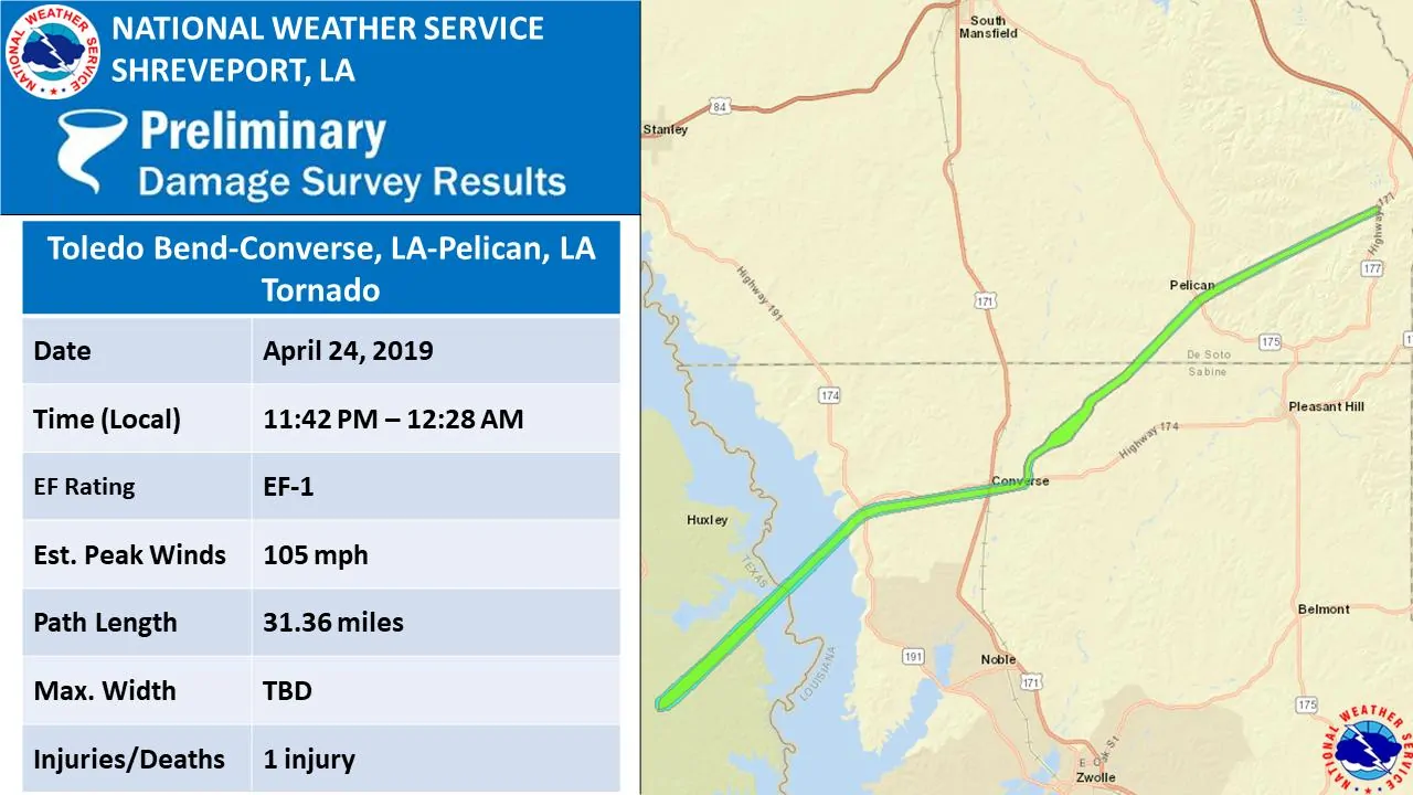
.Tornado #2 – West shore of Toledo Bend to De Soto Parish, LA…
Rating: EF1
Estimated Peak Wind: 105 mph
Path Length /statute/: 32.1 miles
Path Width /maximum/: 900.0 yards
Fatalities: 0
Injuries: 1
Start Date: 04/24/2019
Start Time: 11:42 PM CDT
Start Location: 6 S Huxley / Shelby County / TX
Start Lat/Lon: 31.6723 / -93.8901
End Date: 04/25/2019
End Time: 12:28 AM CDT
End Location: 8 NNE Pleasant Hill / De Soto Parish / LA
End Lat/Lon: 31.9248 / -93.4614
Summary: The tornado touched down west of Toledo Bend Reservoir in
Shelby County near Forest Service Road 126 and continued northeast
crossing County Road 2789 and then County Road 3184 just north of
Forest Service Road 126. It continued northeast just north of
Forest Service Road 126 and went through E. Hillview Lane. It
continued along the same path and crossed Doyle English Lane, near
the Toledo Bend Reservoir at Corris N. Blisteres Road and County
Road 2011 where it left the shoreline and went across Toledo Bend
Reservoir. Numerous trees were snapped and uprooted along this
path. On the Louisiana side of Toledo Bend Reservoir, the path
continued on Highway 191 just south of Highway 174 where it made
an eastward turn and crossed Golden Road. It went through the
town of Converse in Louisiana where several trees were snapped
and uprooted. It again moved to the northeast crossing Highway
171 and Highway 174 and led to tree damage on Harrison Road,
Cooper Lane, and Boliver Road before it crossed into De Soto
Parish. It then caused some tree damage near Pelican, where a
tree fell on a vehicle on Highway 175 just south of the Highway
483 intersection. This resulted in an injury to a female driver
in the vehicle. The tornado continued its northeast movement to
Highway 177 north of Parish Road 507 where it lifted.


0 Comments