
Good morning and welcome to the weekend! I know many of you have plans and want to spend time outdoors, but we’ve got some rough weather to get through first. I’m not going to talk much about what’s going on currently since that’s a nowcast situation. We’ve got a line of severe storms capable of producing hail, heavy rain, and brief tornadoes in the Concho Valley – moving east. A discrete supercell with a tornado threat approaching Uvalde in the Edwards Plateau, and storms with small hail moving northward across D/FW and up into Texoma. This is the start of what will be a busy 8-12 hours in the weather department.
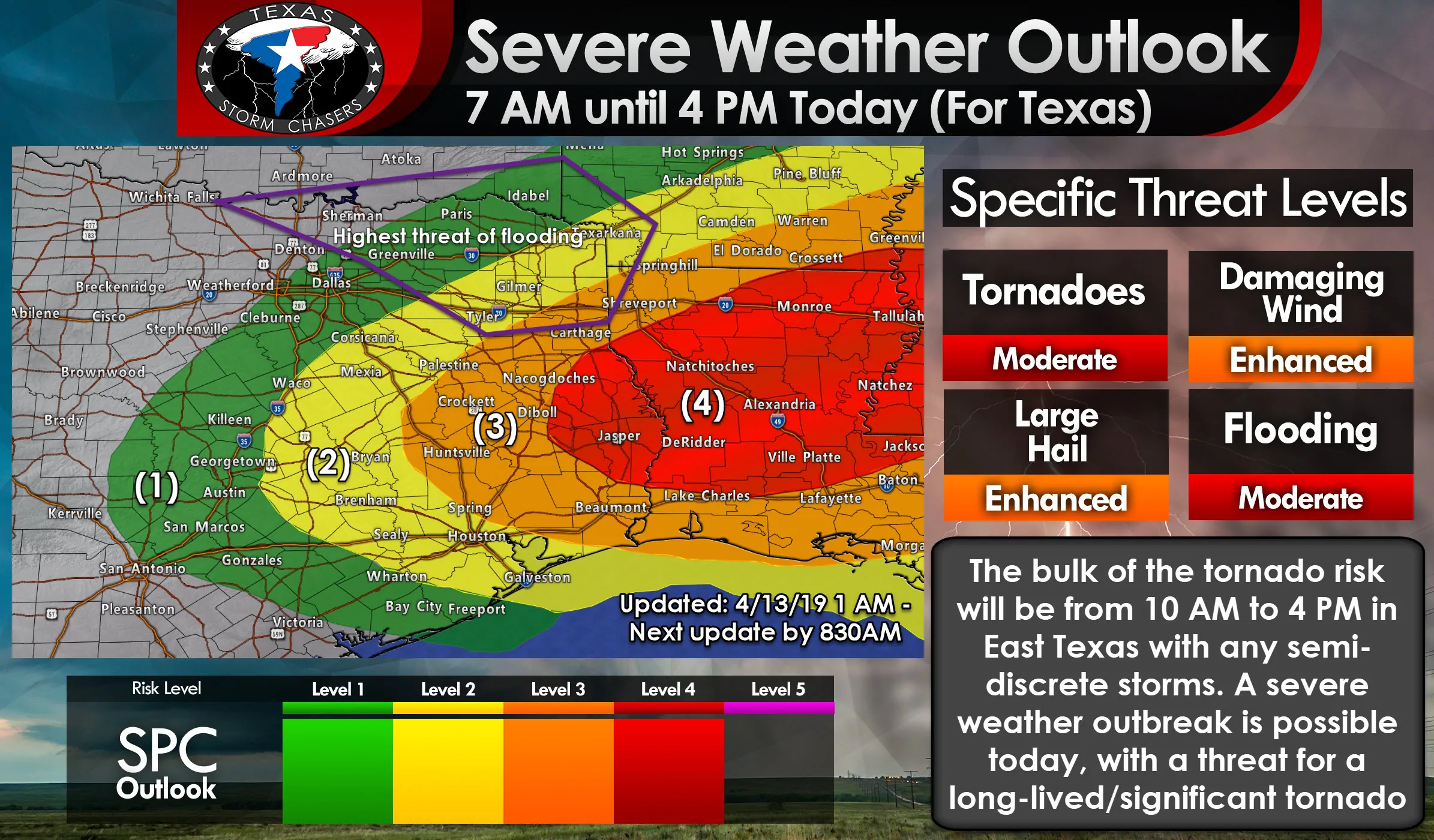
This is the latest severe weather outlook from the Storm Prediction Center. It was issued at 1 AM this morning and goes into effect at 7 AM (so by the time you’re reading this). Just pretend that level 2 risk is back west into the Hill Country, Concho Valley, and Central Texas because it’ll have to be expanded that way when the new outlook is issued at 8 AM. We continue to have an enhancement in severe weather probabilities across much of East Texas, Southeast Texas, back west into the eastern Concho Valley. A level 4 risk is in place across far East Texas into Lousiana and Mississippi where an outbreak of tornadoes is expected this afternoon. The risk of a strong tornado will also exist if any intense supercells are able to develop by the late morning or afternoon hours. That risk may end up extending back west into the level 2 risk as well. Large hail and damaging winds are also expected with the strongest storms. Not all storms today are going to produce tornadoes nor is it a guarantee we end up with a high-end severe weather event in Texas. However, I think we’re going to have some problems. We’ll see what the folks at the Storm Prediction Center do with the outlook update due out around 8 AM.
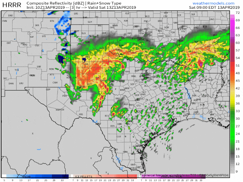
10Z HRRR simulated weather radar from 8 AM to 10 PM today. This is only a weather model simulation, but it’s done pretty well with overnight storms.
Storms in the Concho Valley have likely produced at least two brief tornadoes over the last hour east of San Angelo. I honestly didn’t expect that as the warm front is still a bit to the south. However, the kinematics (wind shear) were able to overcome the less favorable thermodynamics (lack of surface-based instability and a cap). That does concern me because ingredients will only become more favorable as storms move east this morning. Storms on the southern end of the squall line in the Concho Valley will continue to have a tornado threat as they move east into the Hill Country and Central Texas in the coming hours. Storms on the northern end of the line will continue to present a risk of hail and gusty winds as they make their way toward North Texas.
New thunderstorms are expected to develop by late-morning across southeastern North Texas, the Eastern Brazos Valley, into East Texas and Southeast Texas. Any storms south of the warm front, in a very unstable airmass, will be in an environment supportive of tornadoes. Again, a strong tornado cannot be ruled out if we get everything to come together. Very large hail up to the size of baseballs and localized wind gusts over 70 MPH are also likely with the strongest storms.
Storms north of the warm front will be capable of producing large to very large hail, but with a much lower tornado risk. Exactly where that warm front ends up – and how far north it can get – will determine the exact corridor of highest tornado potential by lunch-time and into the mid-afternoon hours.
The most intense severe storms should move east into Lousiana by the late afternoon or early evening hours. Wrap-around moisture will allow for showers and thunderstorms to continue into the evening across Texoma and North Texas. The risk of severe weather will be lower, but some hailers will remain possible.
Today has the potential to be a dangerous day across East Texas, with an even higher risk of a tornado outbreak in Lousiana and Mississippi. It’ll be a close call on whether or not we end up being the ‘starting point’ for that tornado outbreak or if we can get lucky and get those storms out of here before they start dropping big tornadoes. Regardless, take all weather warnings seriously today and ensure you’re ready to go if you have dangerous weather approach.


0 Comments