
A severe thunderstorm watch is expected to be issued for the Edwards Plateau, South-Central Texas, South Texas, and the Coastal Bend in the next hour or two. A line of severe thunderstorms is organizing in northern Mexico. That squall line will move across the Rio Grande and into the United States by 3 AM. The strongest storms may produce large hail up to the size of golfballs, although larger hail cannot be ruled out. Damaging straight-line winds of 60 to 70 MPH are also expected in the stronger storms. The threat for damaging winds may increase later this morning as the squall line makes its way closer to the coast and into the Coastal Bend.
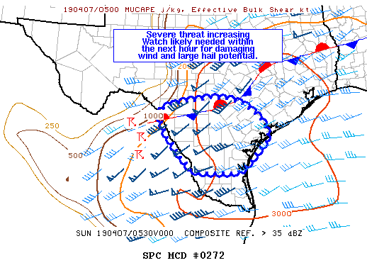
Mesoscale Discussion 0272
   NWS Storm Prediction Center Norman OK
   0100 AM CDT Sun Apr 07 2019

   Areas affected...portions of southern TX

   Concerning...Severe potential...Watch likely

   Valid 070600Z - 070730Z

   Probability of Watch Issuance...80 percent

   SUMMARY...Large hail and damaging wind gusts will be possible
   overnight into the early morning hours across much of southern Texas
   as a cluster of storms in Mexico cross the Rio Grande and shift
   eastward.

   DISCUSSION...The severe threat will continue to increase overnight
   as a cluster of storms over the higher terrain of Mexico shifts east
   across parts of the Hill Country and points south. This convection
   is being forced by increasing ascent as the southern stream
   shortwave trough ejects over northern Mexico. The downstream
   environment is characterized by a very moist boundary layer with
   upper 60s to low 70s dewpoints beneath midlevel lapse rates around
   8-8.5 C/km. This is resulting in MUCAPE values around 2000-3000
   J/kg. Low level easterly flow through the lowest 1km or so is
   relatively weak, ranging from about 10-15 kt, but should increase
   slightly with time. A quasi-stationary front is draped across the
   region from northern Maverick County east/northeast into
   east-central TX. Hi-res guidance suggests convection will organize
   and travel roughly along and south of this boundary in the more
   pristine warm sector airmass.

   Given very steep midlevel lapse rates, hail will be likely in
   embedded stronger updrafts/supercells. Storm mode could temper a
   more significant hail threat, though some very large hail cannot be
   ruled out. While boundary layer inhibition is quite strong at this
   point, strong forcing should be sufficient to weaken low level
   inhibition sufficiently for some damaging wind threat as well.
   Convection will track eastward across much of southern TX through
   the overnight hours and a watch will be within the next hour or so.


0 Comments