
A new tornado watch is in effect for the Brazos Valley and East Texas. This new watch replaces the one previously in effect and generally includes the same locations. Severe weather is ongoing with multiple storms capable of producing very large hail and tornadoes. You can track those storms using our free HD interactive weather radar here or in our free mobile app (click the banner up at the top of the page). One severe storm is east of Madisonville with another near Alto – both moving northeast. Both storms are capable of producing tornadoes and giant hail. Additional hailers are trying to fire up back west in Central Texas – and those may impact Bryan by 7 PM.
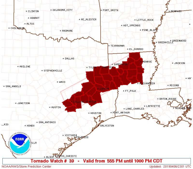
Tornado Watch Number 39
   NWS Storm Prediction Center Norman OK
   555 PM CDT Sat Apr 6 2019

   The NWS Storm Prediction Center has issued a

   * Tornado Watch for portions of
     Northern Louisiana
     Eastern Texas

   * Effective this Saturday afternoon and evening from 555 PM until
     1000 PM CDT.

   * Primary threats include...
     A couple tornadoes possible
     Isolated very large hail events to 2 inches in diameter possible
     Isolated damaging wind gusts to 70 mph possible

   SUMMARY...Clusters of strong to severe storms should persist for a
   few more hours this evening with all hazards possible.
Another round of severe storms late tonight into Sunday – but this time including regions farther south.
We’ll hopefully see a bit of a lull in stronger storms for a few hours this evening, but we’re going to get active around or after midnight. Thunderstorms will develop in northern Mexico this evening. Those storms will move east and cross into the Edwards Plateau between 12 AM and 2 AM. Storms may still be semi-discrete or may already be in the form of a squall line or cluster. Large hail, damaging wind gusts, heavy rain capable of producing localized flooding, and isolated tornadoes are all possible.
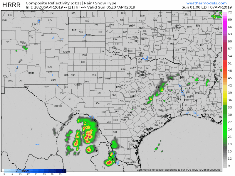
HRRR Simulated weather radar from midnight tonight until 6 PM Sunday. Keep in mind this is only a model simulation, but it is useful for ‘general time planning’ purposes.
As the storms move east pre-dawn Saturday into South Texas we’re expecting upscale growth. They may be in a cluster or squall line. However, once they grow ‘upscale’ we could see the threat for damaging winds along with wind-driven hail increase. We’ve seen several runs of the HRRR model show a bow-echo type structure developing with the storms by 4-6 AM as they enter the western Coastal Plains and continue to progress eastward across South Texas. Should a bow-echo evolve we could see a higher threat of damaging straight-line winds of 65 to 75 MPH in addition to wind-driven hail.
Storms farther north into South-Central Texas and the Brazos Valley could also produce hail, localized damaging winds, and exacerbate and cause new flooding issues along the I-35 urban corridor in Central/South-Central Texas. Eventually, storms may fire up as far north as southern North Texas, Northeast Texas, and East Texas during the morning hours on Sunday. Some of those storms could also be strong to severe with a hail threat.
The squall line tomorrow morning will likely push through all of the Brazos Valley, Coastal Plains, East Texas, and Southeast Texas by the early afternoon. Severe weather will remain possible with those storms as they move east of Texas and into Louisiana. Damaging straight-line winds and hail up to the size of golfballs are expected with stronger storms in that line. Brief tornadoes cannot be ruled out, particularly if any one storm int he squall line exhibits supercellular characteristics or ‘bows’ out.
Additional thunderstorms may fire up tomorrow afternoon across the eastern half of Texas. We’ll have to see if the enviornment can recover from morning storms, but wind shear values and instability could support more hailers. We’ll deal with that once we get through our current round of storms.


0 Comments