
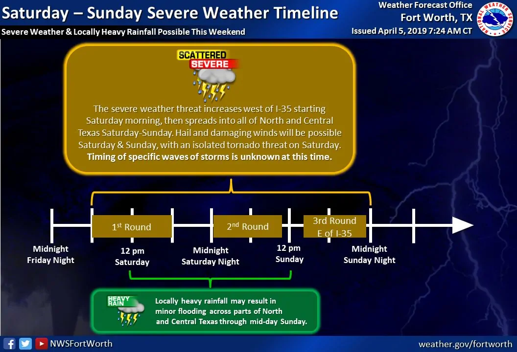
A line or cluster of strong to severe thunderstorms will move east across the eastern two-thirds of Texas over the next 24 to 30 hours. This will be a difficult and messy forecast as multiple rounds of storms, along with varying storm modes, will make it difficult to pin down specific timeframes for a given location.
Isolated storm development is expected across West Texas south into the Permian Basin early this evening. Those storms will move northeast with a threat of hail and localized damaging wind gusts. The ‘main show’ is expected to start after midnight into early Saturday morning as stronger upper-left lift arrives. A line of storms will fire up in West Texas and the Permian Basin. Those will move east into North Texas, the Big Country, and the Concho Valley early Saturday morning. That takes us into Saturday…
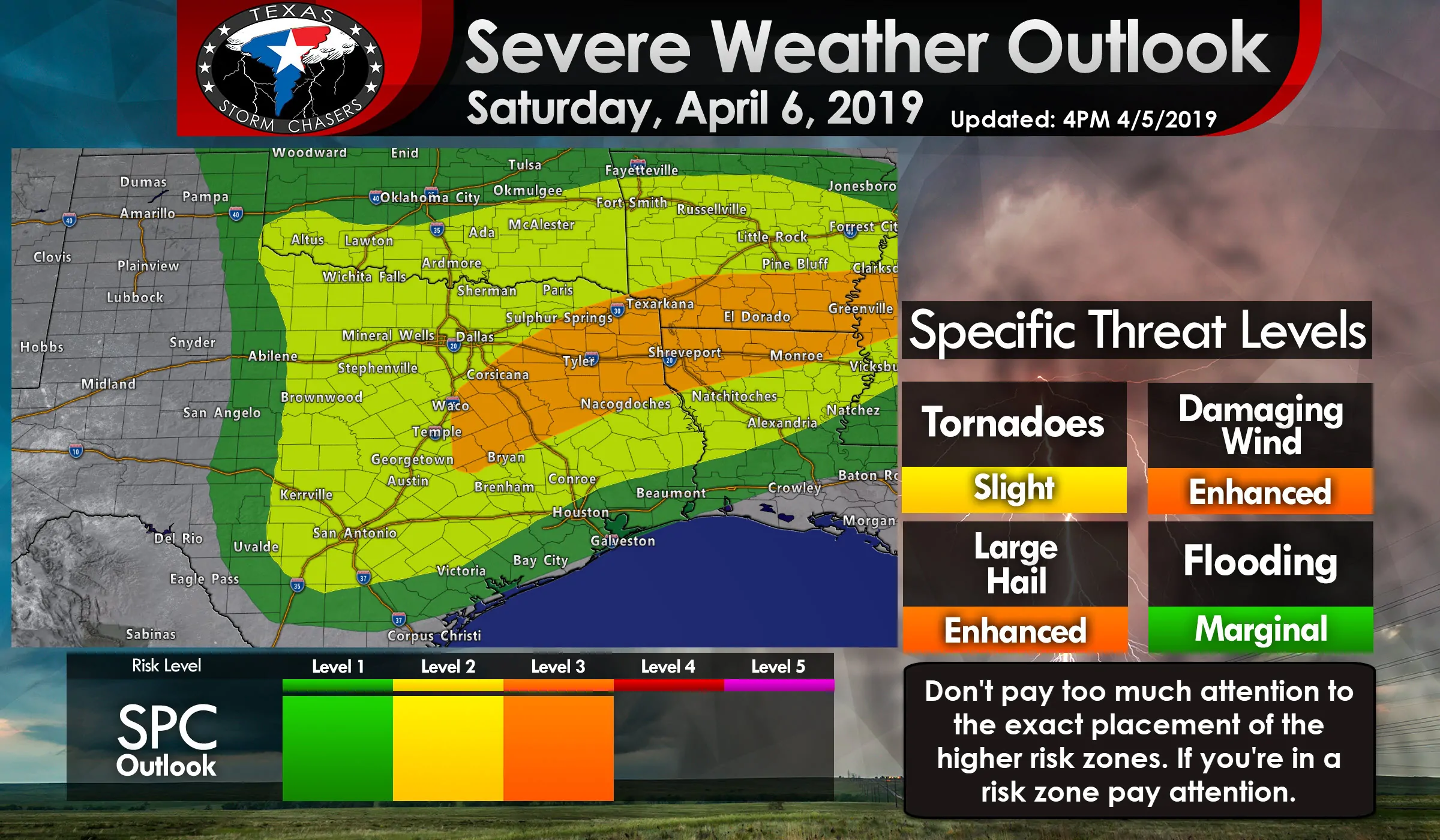
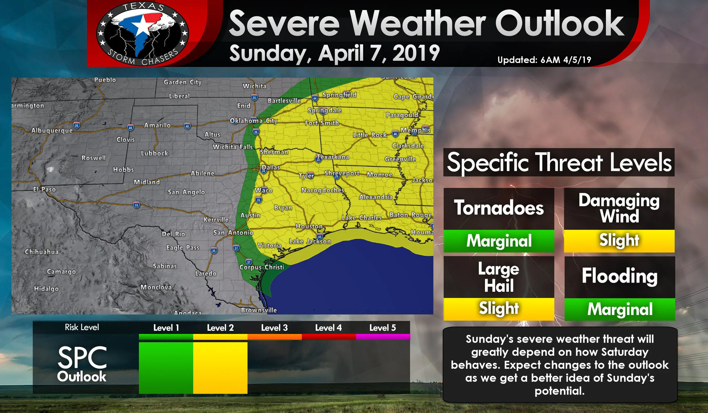
A level 2 severe weather risk includes the eastern half of Texas tomorrow, generally from near Highway 62/83 and east. Northwest Texas, the Big Country, the Hill Country, South-Central Texas, Central Texas, North Texas, Northeast Texas, East Texas, and the Brazos Valley are all included. We do note that an enhancement has been made with a level 3 risk in place across much of East Texas back west into the northern Brazos Valley and southern North Texas. That is where the highest coverage of damaging wind/hail reports are expected.
However, I want to emphasize that the exact line placements don’t matter. Storms don’t read or care about our maps. There will be some changes to the exact line placements in later outlooks. Whether that means the higher risk zones get expanded north or west is still to be determined. If you’re in any of the risk zones you have a risk of strong to severe storms in your vicinity on Saturday.
Damaging straight-line winds up to 70 MPH and hail up to the size of golf balls will be the primary severe weather threats both with storms today and with those on Saturday. Isolated tornadoes cannot be ruled out, but there are a few hindrances that look to prevent a comparatively higher threat. I can’t rule out isolated occurrences of very large hail up to the size of tennis-balls along with isolated hurricane-force downbursts (very localized wind events) if we end up having intense supercell modes and/or bowing line segments over the next day.
One big uncertainty tonight into Saturday morning is on how far south the line of storms will develop. One of my favorite models, the High-Resolution Rapid Refresh model (HRRR) keeps a majority of the thunderstorm activity north of the Edwards Plateau and Hill Country overnight. Another high-resolution weather model (the North American Model) has a line of storms from the Mexico border northward into Oklahoma.
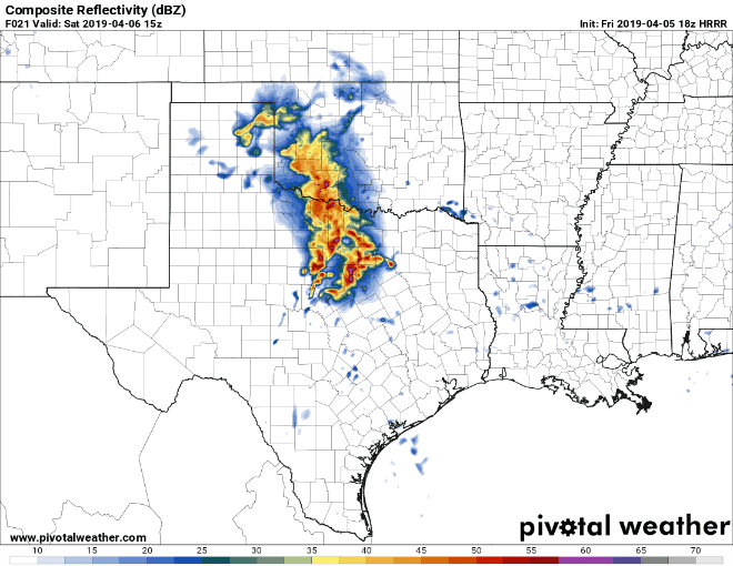
Comparison between two weather models for 10 AM Saturday. One model has most storms across the northern half of Texas while the other has a squall line from Oklahoma south into the Edwards Plateau. This is just one of several uncertainties that make for a complicated forecast.
The reason for that stark differences seems to be how each model handles the squall line’s behavior. One model has an outflow boundary that helps to spark off storms farther south, while the other model doesn’t pick up on that. The upper-level lift will certainly be stronger across the northern half of Texas, but conditions farther south would certainly support organized thunderstorms. I’m not ready to say that storms won’t indeed end up occurring farther south too, but unfortunately, that’s going to be a ‘nowcast’ sort of event. The severe weather outlook for tomorrow takes that potential into consideration.
A second big reason for the uncertainty is that much of this storm system’s energy will be coming in from Mexico. They don’t have an upper air network of weather balloons – meaning weather models just have to guess on some of the parameters. If the system is stronger than a model’s guess the forecast can change quickly.
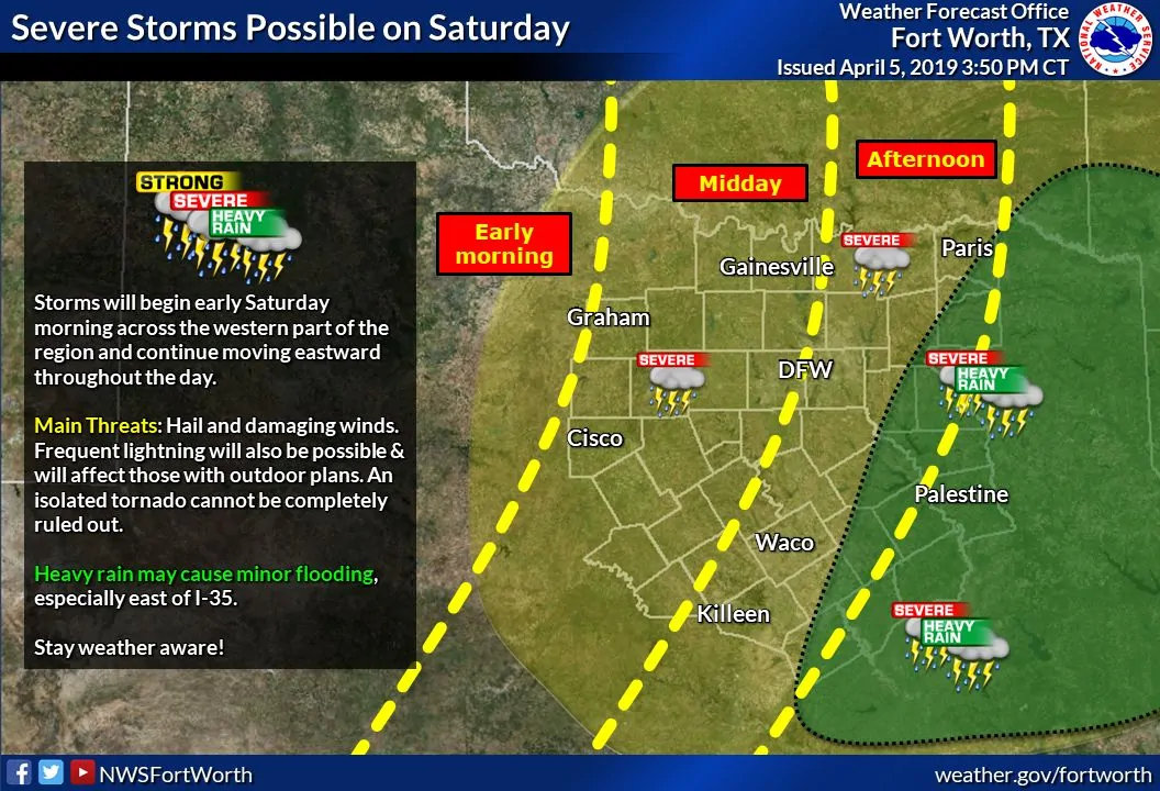
Storms that do get going late tonight in West Texas and the Permian Basin will likely organize into a squall line or cluster. Those storms will move east/northeast toward Northwest Texas, the Big Country, the Concho Valley, and eventually into North Texas by the mid-morning to early afternoon hours on Saturday. Not all storms will be severe, but some will be capable of producing large hail and localized damaging wind gusts. The threat of brief tornadoes will exist, but the tornado threat itself should remain low. Heavy rainfall may cause minor flooding, especially in urban areas.
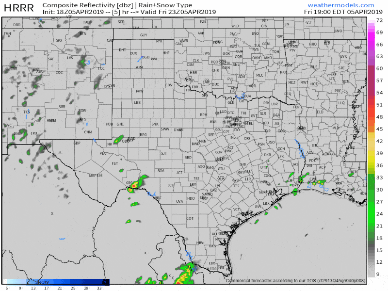
18Z HRRR: Simulated weather radar from 7 PM this evening until 12 AM Sunday. Please note that this is just one potential solution and that storms may end up being more expansive than what this one model shows (see our discussion above for an explanation of the uncertainties).
Additional thunderstorms will develop across North Texas and Central Texas early Saturday afternoon, perhaps southward into the Brazos Valley. Those storms will move east/northeast and could also contain large hail, localized damaging wind gusts, and perhaps isolated tornadoes. That activity will move into Northeast Texas and East Texas tomorrow afternoon and tomorrow evening.
Isolated thunderstorms may redevelop along a dryline across the eastern Texas Panhandle, western Oklahoma, south into the Big Country late tomorrow afternoon *if* the atmosphere is able to destabilize. That’s not a guarantee and will be something we’ll get a better grasp on tomorrow. Those isolated storms would move east/northeast with a threat of large hail through the mid-evening hours. At this time it does not appear that those will grow ‘upscale’ into a squall line or storm cluster.
Sunday’s Severe Weather Chances
Sunday’s forecast is very low confidence due to uncertainties on the atmosphere recovering after Saturday’s storms. If the atmosphere is able to destabilize we could see isolated to scattered thunderstorms fire up near Interstate 35/35W Sunday afternoon. Those storms would generally move east with a threat of large hail, localized damaging wind gusts, and perhaps a threat of localized flooding. We’ll deal with Sunday once we get past the storms tonight and tomorrow morning. Just know that another round of storms is possible again on Sunday into Sunday evening across the eastern third of Texas.
We’ll have another update around 10 PM with any changes in the forecast for the overnight period into Saturday. Updates sooner if necessary.


0 Comments