
It’s been a relatively quiet stretch of weather which has been welcome given our active first two weeks of March. I’m sure many are enjoying the pleasant and dry weather (myself included), but we do have some changes coming by the end of the work week and for the weekend. Now before folks start huffing and puffing to blow away the storms let me be clear that we’re not expecting widespread severe weather at this time. The forecast from Friday through Sunday does feature multiple chances for storms. However, at this time, this setup seems to favor more of a ‘good soaker’ versus a ‘big hailer or spinny whirlwind of death’ event.
Chance of rain/storms on…
We’ll be dealing with two pieces of upper-level energy over the weekend. A potent, fast-moving piece of upper-level energy will bring thunderstorm chances to the Texas Panhandle, West Texas, south into the Permian Basin on Friday. This may be in the form of several clusters or a large band of thunderstorms.
All of that rainy mess will move east Friday night and on Saturday, resulting in expanding precipitation chances as shown in the graphics above. Instability values will be limited to near zero, so the threat of severe weather looks to be low. A few storms may become strong with gusty winds and small hail. Locally heavy rainfall is probably going to be the main threat.
A conditional risk of a few stronger storms may exist Saturday afternoon. That’ll be as our second piece of energy arrives. It’ll be slower-moving and weaker. A dryline should be located across Northwest Texas southward into the Big Country. The expectation is widespread cloud cover along with modest dewpoint values will tend to limit the threat. We’ll keep an eye on it in case that changes.

The dryline will be a bit further east on Sunday. Warm-air advection Saturday night into Sunday will result in higher dewpoint values and higher instability compared to the previous two days. A few severe storms are possible Sunday afternoon to the east of the dryline. Data at this point, which will change as we get closer, suggests the highest threat for severe storms will be from Central Oklahoma southward into Texoma and the Red River Valley. This looks like one of our typical ‘spring’ days with a few severe storms that could be hailers. We’ll get detailed with each specific severe weather threat once we’re closer.
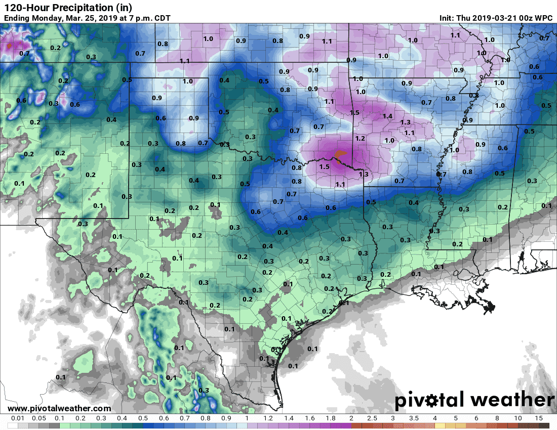
Potential rain totals from Thursday through Monday
Overall we’re expecting this weekend’s precipitation event to produce the highest rain totals across the Texas Panhandle southeastward into North Texas and Northeast Texas. A few spots may have to deal with localized flooding. Widespread flooding is not expected nor is significant flash flooding.


0 Comments