
A very strong cold front has now pushed through a majority of Texas. It has pushed out into the Gulf of Mexico and south of the Rio Grande Valley. While the northerly winds have brought nasty wind chills, I can’t help but watch what has happened in the Southeastern United States today. One of the deadliest tornado events in several years has killed at least 14 individuals, including children, in eastern Alabama. They’re still doing search and rescue at the time of this writing. It may feel like the front porch of the North Pole tonight, but the spring severe weather season isn’t that far off here in Texas.
Chance of snow showers tonight and on Monday?
I want to make it clear that we are not expecting a high-impact winter weather event with this cold-snap here in Texas. Most of the snow with this system has already fallen this morning across the Texas Panhandle and West Texas. Temperatures will not rise above freezing in those regions until Tuesday, so if roads are bad, they only way they’ll improve is by sanding, plowing, or sublime from the strong winds tonight. Don’t go out like a speed demon or the only place you’ll be speeding to is a roadside ditch.
We *may* see a few snow showers tonight and tomorrow across the northern half of Texas. I use that broad geographic description because we have a weak storm system moving overhead over the next 18 hours. This kind of cold airmass can squeeze out a few snow showers pretty easily. We’re not expecting widespread snow accumulations, and even those who end up under a snow shower may only see enough to make for a dusting. However, we’ll keep an eye on it just in case mother nature wants to give us a little surprise.
The cold has arrived…
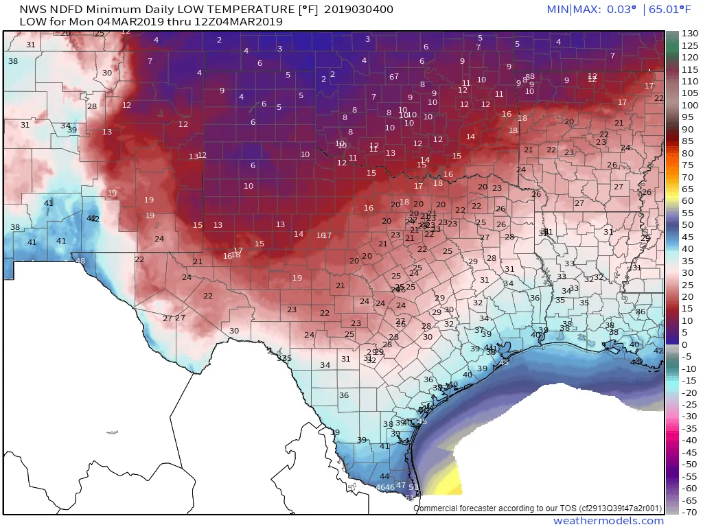
Monday Morning’s Low-Temperature Forecast
Temperatures by sunrise tomorrow will be in the single digits across the Texas Panhandle and West Texas, Teens are expected as far south as Midland to Abilene to Decatur to Sherman. The freezing line will make it south through the Hill Country and the Brazos Valley. We note that the freeze line will actually make it farther south by Tuesday morning, so growers be aware. 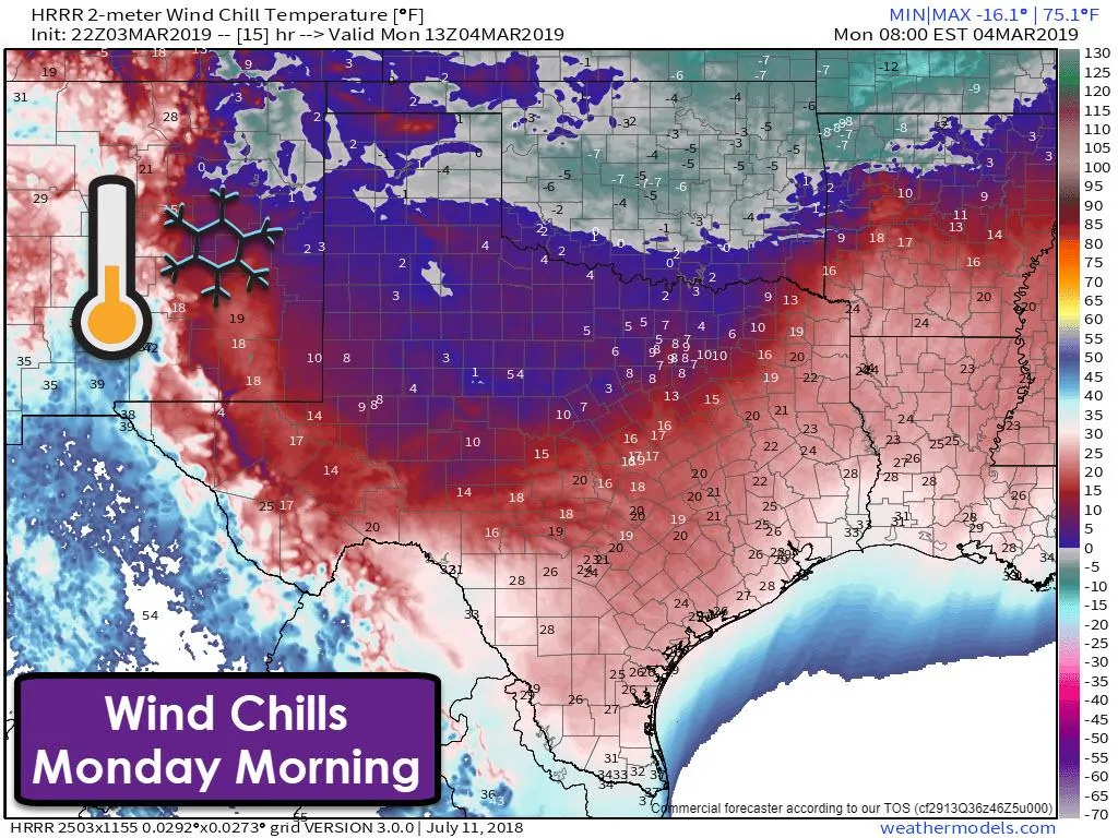
While the air temperature will be cold enough tomorrow, wind chill values are going to be much colder. Sub-zero wind chills are expected across the Texas Panhandle and West Texas. Single digit wind chills, some approaching zero, are anticipated across the Permian Basin, Big Country, Northwest Texas, Texoma, and North Texas – including the D/FW Metroplex. This type of cold can be dangerous to those exposed.
Wind chills in the teens will be common across Central Texas, the Hill Country, extending into East Texas. In fact, the only place not expecting wind chills below freezing tomorrow morning is in the Borderland (El Paso) and the Rio Grande Valley, although low 30 wind chills are still quite cold for them.
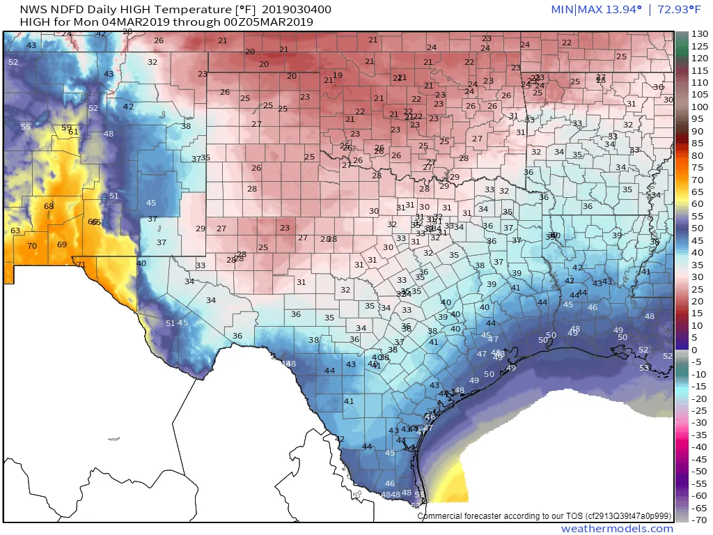
Monday’s High-Temperature Forecast
Temperatures are not going to get above freezing on Monday if you’re north of the Permian Basin, the Concho Valley, Central Texas, and Northeast Texas. In fact, temperatures may not even hit 30 degrees along and north of Interstate 20 from Midland to D/FW. Those in Austin, San Antonio, and Houston may be able to climb into the 40s tomorrow, but wind chills will remain in the 20s and 30s. It’s going to be cold and nasty.
Hard freeze for a lot of Texas by Tuesday morning.
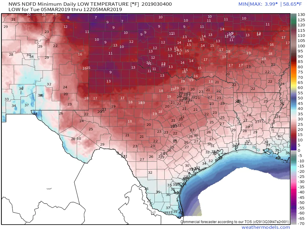
Tuesday Morning’s Low Temperature Forecast
A hard freeze (temperatures below 28 degrees) is expected Tuesday morning for all of Texas except the following locations: the Borderland, far South Texas, the Rio Grande Valley, and those within about 20 miles of the coast. Everyone else will be dipping below freezing, and most likely into the ‘hard freeze’ category for several hours. That means any unprotected vegetation that has begun growing could be damaged or destroyed. We know the growing season has already started, so this could be a particularly damaging event for early-season crops and plants.
It’s cold now, but above-average temperatures return by Thursday. Strong to severe weather possible on Saturday
Tuesday will be another cold day, but we will start to see temperatures rebound by Wednesday. A more rapid warm-up is expected on Thursday and by Friday temperatures across Texas will be at or above average with the 60s and 70s. We note that our next strong upper-level storm system will arrive on Saturday. Unlike this weekend, next weekend’s storm system will be more ‘spring-like’. We’ll need to watch trends closely as we may have a threat of strong to severe thunderstorms – and as today’s events in Alabama have shown, severe weather season is already here.


0 Comments