
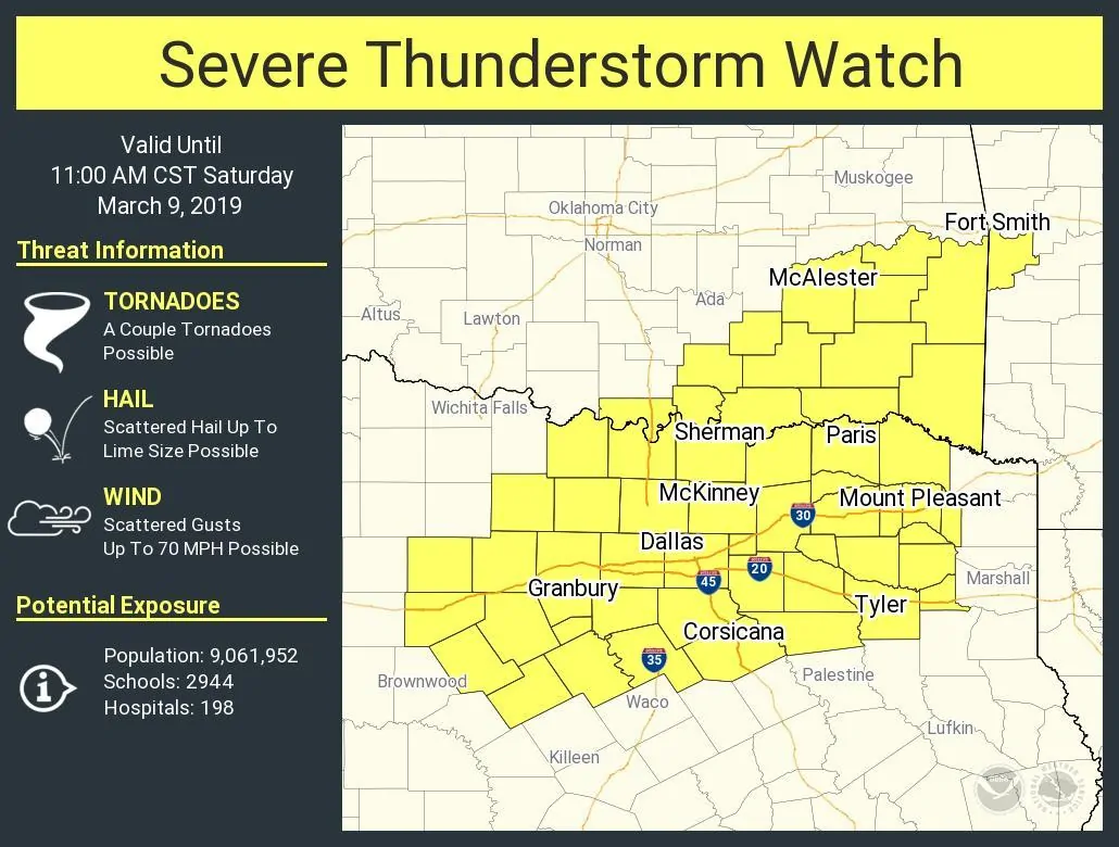
A severe thunderstorm watch is now in effect until 11 AM for much of North Texas into portions of Northeast Texas. Granbury, D/FW, Sherman, Corsicana, Paris, Mount Pleasant, and Tyler are a few cities included in this watch. This watch will be trimmed from west to east as thunderstorms quickly move east through the late morning hours. The strongest storms may produce hail larger than the size of golfballs, localized wind gusts up to 70 MPH, and an isolated tornado threat can’t be ruled out. The highest threat for damaging winds and an isolated tornado will generally be from D/FW and east/northeast into Northeast Texas later this morning.
Thunderstorms are intensifying this morning across western North Texas into the northern suburbs of the D/FW metroplex. At the time of this writing the storm approaching Mineral Wells to Morgan Mill. Most storms are moving east/northeast at 55 to 70 MPH. They’re booking it and they don’t have to stop at traffic signals or curve around hills. Stay tuned to the latest weather information through the morning. We’ll be posting rapid-fire updates on our Twitter account and will go live on our social media accounts if the situation dictates.
Severe Thunderstorm Watch Number 11
   NWS Storm Prediction Center Norman OK
   345 AM CST Sat Mar 9 2019

   The NWS Storm Prediction Center has issued a

   * Severe Thunderstorm Watch for portions of
     Extreme western Arkansas
     Southeastern Oklahoma
     North-central and northeast Texas

   * Effective this Saturday morning from 345 AM until 1100 AM CST.

   * Primary threats include...
     Scattered large hail and isolated very large hail events to 2
       inches in diameter possible
     Scattered damaging wind gusts to 70 mph possible
     A tornado or two possible

   SUMMARY...The severe-hail and wind threats are expected to increase
   through mid/late morning local time, as a belt of thunderstorms
   fills in from eastern Oklahoma to north-central Texas.  Activity
   then will cross the watch area moving eastward to northeastward.  A
   tornado cannot be ruled out, and some parts of the region may need a
   watch upgrade in a few hours, if organization of the tornado threat
   increases beyond more than a brief/marginal basis.
   .    TEXAS COUNTIES INCLUDED ARE

   BOSQUE               CAMP                COLLIN
   COMANCHE             COOKE               DALLAS
   DELTA                DENTON              EASTLAND
   ELLIS                ERATH               FANNIN
   FRANKLIN             GRAYSON             GREGG
   HAMILTON             HENDERSON           HILL
   HOOD                 HOPKINS             HUNT
   JACK                 JOHNSON             KAUFMAN
   LAMAR                MONTAGUE            MORRIS
   NAVARRO              PALO PINTO          PARKER
   RAINS                RED RIVER           ROCKWALL
   SMITH                SOMERVELL           STEPHENS
   TARRANT              TITUS               UPSHUR
   VAN ZANDT            WISE                WOOD


0 Comments