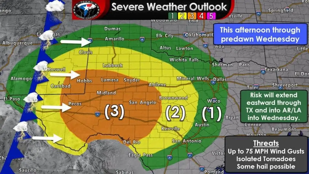
Since this is our first higher threat of severe weather this year we’ll be going extra detailed with the severe weather risk zones. If you’d like to learn more about what each risk level means and how these severe weather outlooks are created visit our severe weather page here. Let us know what you think of us going ‘super detailed’ or if you liked us remaining vaguer by generalizing with regions. Pay attention if you’re in or near any of the risk zones.
Level 3 Risk: Permian Basin, western Big Country, Concho Valley, western Edwards Plateau. Includes Alpine, Fort Stockton, Pecos, Odessa, Midland, Sanderson, Big Lake, Big Spring, Lamesa, Post, Snyder, Ozona, Sonora, Junction, San Angelo, Sterling City, Sweetwater, and Abilene. A nearly 1/3 chance of having damaging wind gusts over 60 MPH within 25 miles of your location. Isolated tornadoes and spotty hail are also possible.
Level 2 Risk: West Texas, western North Texas, and the Hill Country. Includes Van Horn, Presidio, Panther Junction, Morton, Lubbock, Aspermont, Guthrie, Matador, Childress, Crowell, Plainview, Dimmitt, Haskell, Brownwood, Brady, Burnet, Fredricksburg, Boerne, Kerrville, Uvalde, Del Rio, Graham, and Stephenville. A nearly 1 in 5 chance of damaging winds over 58 MPH within 25 miles of your location Brief spin-up tornadoes may occur in association with those damaging straight-line winds as the squall line moves east.
Level 1 Risk: Borderland, Texas Panhandle, Northwest Texas, North Texas, Northeast Texas, Central Texas, East Texas, South-Central Texas, Brazos Valley, and Southeast Texas. This includes El Paso, Fabens, Sierra Blanca, Amarillo, Clarendon, Wellington, Shamrock, Pampa, Borger, Dumas, Dalhart, Perryton, Canadian, Vernon, Wichita Falls, Gainesville, Denton, McKinney, Fort Worth, Dallas, Hillsboro, Waco, Corsicana, Temple, Killeen, Georgetown, Austin, New Braunfels, San Antonio, Gonzales, Pleasanton, Carrizo Springs, Eagle Pass. Some of the locations across North Texas and Central Texas could be upgraded to a level two risk in updates later today.
The risk will translate eastward as we continue through Wednesday morning and early Wednesday morning. That risk includes Georgetown, Austin, New Braunfels, Gonzales, Cuero, La Grange, Temple, Waco, Fairfield, Corsicana, Centerville, Palestine, Canton, Texarkana, Tyler, Longview, Lufkin, Crockett, College Station, Columbus, Houston, Freeport, Galveston, Livingston, Port Arthur, Beaumont, and Woodville.
A level one risk means you have a 5% chance of experiencing severe weather within 25 miles of your location. That includes damaging wind gusts over 58 MPH for this event.
We’ll share an updated severe weather outlook around 3 PM this afternoon here on the blog. You can visit our severe weather page for the new outlooks that are released at 8 AM, 1130AM, 3 PM, and 8 PM today.
Timing

06Z HRRR Simulated Weather Radar from 5 PM CT today through 12 PM Wednesday. This is only a simulation and given it is an ‘extended-range’ version of the short-term model, the verification rate will likely be lower. Please use this as a general guideline on the timing of storms, and understand it’ll likely be somewhat different by the time you check back for an update this afternoon or evening.
Isolated to scattered severe thunderstorms may be underway as soon as 4-5PM CT from the Davis Mountains north into southeastern New Mexico. These initial storms may be discrete and could attain supercelluar characteristics. If we were to see much of a hail threat today it would be from those storms. A few tornadoes are possible and we may see a small enhancement of the tornado risk in New Mexico. Storms would move northeast. Most of the late afternoon and early evening hours may see the highest severe risk in eastern New Mexico.
A line of strong to severe storms capable of producing damaging straight-line winds and brief tornadoes should be entering the Texas Panhandle, West Texas, and Permian Basin in the 8-11PM timeframe. Individual storms within in the squall line will move north/northeast while the line itself moves east.
By 12-2AM Wednesday the line of storms should be entering the western sections of the Big Country and Concho Valley. The strongest storms within the squall line will likely be capable of producing damaging straight-line winds and brief tornadoes. Some small hail can’t be ruled out, but this setup doesn’t favor hail as much.
By 3 to 5 AM the line of strong to severe storms should be moving east across Northwest Texas, the Big Country, the Concho Valley, into the Edwards Plateau. The line of storms will begin approaching North Texas and the Hill Country. There are indications the line may begin accelerating eastward by this point, which would place the line of storms near Interstate 35 from Gainesville to Hillsboro around 6 AM Wednesday.
Some storms in the line may still be severe with a risk of damaging straight-line winds and brief tornadoes. The line itself may not look as impressive on radar due to low instability values, but the strong winds aloft could still promote damaging winds. We’ll have to see how far east the line can get before it starts losing steam. It could be strongest over North Texas Wednesday morning and weaker farther south in Central Texas as the strongest dynamics/winds will be farther north.
However, given the very dynamic support aloft, I’m hesitant to say that storms (or even a line of showers) may not produce strong wind gusts farther south. We may see some intensification of storms after sunrise on Wednesday as we start to see some warming. That could result in some additional strong storms across the eastern third of Texas on Wednesday.
This is the kind of forecast that could change between now and this evening for our Interstate 35 friends, so please check back later this afternoon for the latest updates. We are planning to provide weather coverage throughout the night and into the morning hours Wednesday. While I’m not explicitly forecasting it at this point, tonight could up featuring a widespread damaging wind event along with spinup tornadoes as the squall line moves east across the Permian Basin, Big Country, Concho Valley, into North Texas. Check back for updates and make sure any of your friends/family that are camping or spending their spring break outdoors tonight and Wednesday morning know about the threat of severe weather.
If all of that wasn’t enough, we’re going to be dealing with a high-impact very strong non-thunderstorm wind event Wednesday afternoon across the Texas Panhandle, West Texas, Permian Basin, Concho Valley, Big Country, and Northwest Texas thanks to that very strong low-pressure, clearing skies, and warming temperatures that’ll mix down strong winds aloft. We’ll deal with that a bit later. One event at a time. 🙂
A little discussion/chat about tonight’s setup (some of the uncertainties, alternatives, etc).
Tonight’s severe weather setup will be a very high shear, low instability event. These events are typical of the ‘cool season’. Although we’ll be going beyond the ‘high shear’ aspect and elevating up into the ‘ridiculous’ category. A surface low pressure in eastern Colorado will undergo near-bombogenesis tonight into Wednesday as it moves east into Kansas. That surface low will intensify from about 993 millibars down to around 975 millibars. It’s possible it goes even lower than that. That will come close to setting the all-time record low pressure recorded in Kansas. A cool statistic for weather nerds, but what’s that have to do with our forecast?
The lower the pressure goes the more intense wind-fields become at the surface and aloft. As a Pacific cold front and associated line of thunderstorms moves east overnight and on Wednesday winds just above the surface will screaming out of the south at 75 to 100 MPH. Several of the meteorological methods of measuring wind shear aloft are in the ‘extreme’ category. We’re going to have extreme wind shear values in place tonight as that squall line moves eastward from the New Mexico border all the way to Interstate 35 by around 5-6AM Wednesday.
The biggest uncertainty precluding a full-on severe weather outbreak is the available instability for thunderstorms. There will be modest amounts of instability this afternoon and evening across the Permian Basin, West Texas, and in the Concho Valley. That’s why there’s an enhanced severe weather risk in place. Further to the north and east instability values are projected to be low to almost zero. Typically that would result in a low/minimal severe weather risk.
Unfortunately, given the extreme amounts of wind shear aloft along with the extremely strong lift due to the rapidly intensifying surface low in Kansas, we may still get severe weather even though instability values are minimal. That severe weather would be in the form of damaging straight-line winds and even brief tornadoes on the leading edge of the squall line.
With such strong winds aloft all we may need is that line of showers/storms to transfer via downward momentum some of those higher winds to the surface. That will be the main question across Texoma, North Texas, and Central Texas by 3-7AM Wednesday. If we do end up having more instability than indicated the severe weather risk will need to be upgraded farther to the east.


0 Comments