
A tornado watch is now in effect until 11 PM CT for portions of the Davis Mountains, Trans-Pecos, western Permian Basin, and the westernmost column of counties in West Texas. We’ll be watching for thunderstorms to develop in southern and southeastern New Mexico along with the Davis Mountains over the next few hours. Those storms will progress northeastward with a threat of tornadoes, large hail, and localized damaging wind gusts. Additional storms will form later this evening and grow upscale into a squall line. Those are the storms that will move eastward and impact the Texas Panhandle, West Texas, Permian Basin, Concho Valley, Edwards Plateau, Hill Country, Big Country, Northwest Texas, and North Texas late tonight and into the morning hours on Wednesday. Damaging straight-line winds, potentially widespread, will be the primary threat. Brief tornadoes are possible as well. See our previous blog updates for more on tonight’s storm chances.
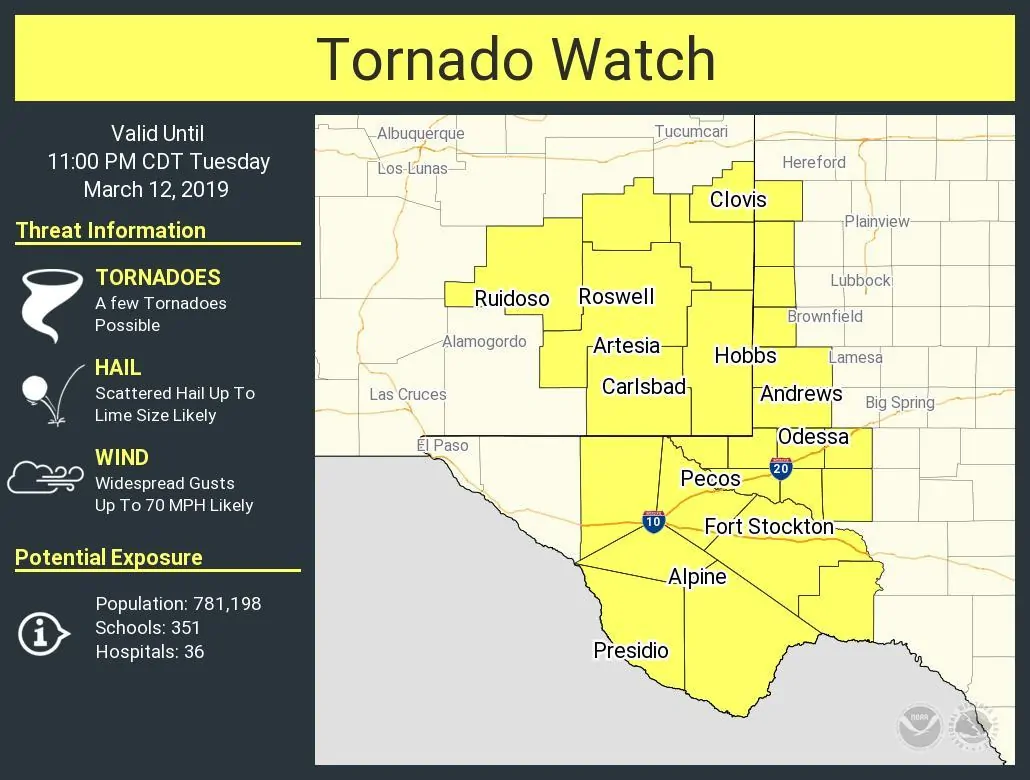
Tornado Watch Number 17
NWS Storm Prediction Center Norman OK
330 PM MDT Tue Mar 12 2019
The NWS Storm Prediction Center has issued a
* Tornado Watch for portions of
eastern New Mexico
southwest Texas
* Effective this Tuesday afternoon and evening from 330 PM until
1000 PM MDT.
* Primary threats include…
A few tornadoes possible
Widespread damaging wind gusts to 70 mph likely
Scattered large hail likely with isolated very large hail events
to 2 inches in diameter possible
SUMMARY…Storms are expected to increase in coverage and intensity
from eastern New Mexico and spreading into southwest and west Texas.
Supercells evolving into line segments with damaging wind are likely
and a few tornadoes and large hail are also possible through the
evening.
The tornado watch area is approximately along and 60 statute miles
east and west of a line from 70 miles north northeast of Roswell NM
to 55 miles east southeast of Marfa TX. For a complete depiction of
the watch see the associated watch outline update (WOUS64 KWNS
WOU7).
PRECAUTIONARY/PREPAREDNESS ACTIONS…
REMEMBER…A Tornado Watch means conditions are favorable for
tornadoes and severe thunderstorms in and close to the watch
area. Persons in these areas should be on the lookout for
threatening weather conditions and listen for later statements
and possible warnings.


0 Comments