
Congratulations on surviving the last several days of arctic chill in Texas. I know that folks get antsy when temperatures get below 40 degrees, so bravo on not raiding the grocery for milk and bread. Now that my mid-week sarcasm is out of the way… most readers will be pleased to know that today marks the beginning of the climb up the temperature roller coaster. High temperatures this afternoon will be several degrees warmer than yesterday, and a good warm up into the 50s and 60s are expected for Thursday.
Friday’s temperature forecast is going to be a bit more tricky. Another one of our favorite cold fronts will be nosing into the region. By ‘favorite’ I mean one that contains a shallow, cold airmass. Like nine days ago or so this front may end up sneaking farther south than weather models indicate. The graphic I’ve included in this morning’s blog does not explicitly show that solution.
However, temperatures north of the front would tend to be in the 50s to lower 60s on during the day Friday. It is not out of the realm of possibility (if not a half/half bet) that the front noses south into the eastern Texas Panhandle, Northwest Texas, the Big Country, and North Texas.
If that ‘cooler’ solution pans out we’ll see the front lift north as a warm front Friday night – with ‘high temperatures’ for the day Friday occurring in the evening hours. This little front uncertainty will also play into Saturday’s thunderstorm potential.
Thunderstorm chances on the rise for Saturday
We’re still four days out from potential stormy mischief on Saturday. One can tell that simply by looking at weather model data and some timing disagreements still showing up. For example, models are disagreeing on the timing of the dryline’s eastward movement on Saturday.
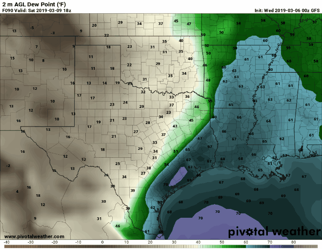
Three different weather models showing surface dewpoints at 12 PM on Saturday. Notice some have the dryline farther east while some are farther west. These are typical discrepancies that get worked out closer to an event. That’s why we try not to get too specific when we’re still 3+ days away.
Some models have the dryline approaching the Arklatex by early afternoon Saturday while others have the dryline back along the Interstate 45 corridor. These are typical uncertainties at the 72+ hour timeframe and will resolve themselves as we get closer and into higher-resolution weather model data. Regardless, wind shear aloft will be favorable for organized thunderstorms (as is often the case with ‘winter’ systems).
Another question will be the amount of instability available for thunderstorms on Saturday. It looks like we may have a round of early morning thunderstorms fire up across North Texas into Texoma. Those storms would be elevated above a stable layer at the surface. However, enough instability aloft would exist for some of those storms to become strong with a hail threat. It may well be a case that so many storms fire up that the strongest produce lots of small hail – versus a lower number of storms producing larger hail.
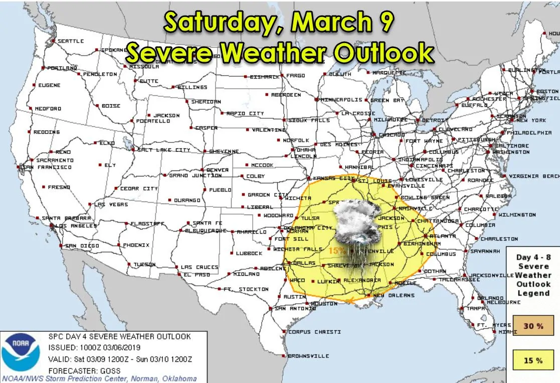
As thunderstorms move east of I-35 by the mid-morning hours into Northeast Texas and East Texas it is possible they make begin to intensify as surface-based instability values increase across those regions. This would be where the potential for larger hail (quarter size and larger) increases along with the potential for localized damaging wind gusts. The eventual threat level for each specific hazard (hail, wind, tornado) will be determined once we’re closer to Saturday.
I can say that the potential for tornadoes does look the highest east of Texas. Parts of Arkansas, Lousiana, Mississippi, Tennesee, and Alabama may be under the gun with another severe weather event. We may end up being at the starting gate in Texas, but like the last two systems over the last two weekends, storms may end up not maturing until they’ve exited Texas Saturday afternoon.
That solution isn’t locked in and changes are probable over the next 72 hours. Once the upper-level storm system moves onto the West Coast and we get within range of higher resolution weather models we’ll be able to start narrowing down timing, specifics threats, and where those threats will be highest.
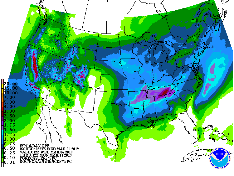
Potential rain totals through Sunday night (with most rain falling Saturday)
Even with the slower model solutions, we expect thunderstorm activity to mostly exit Texas to the east by the mid-afternoon to late afternoon hours Saturday. There won’t be much cold air behind the system, so temperatures won’t drop off all that much. In fact, temperatures west of the dryline on Saturday may be fairly warm as dry westerly winds commence.
More storms and heavy rain brewing next week
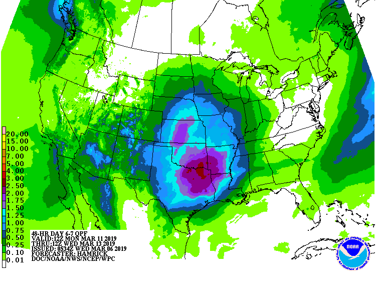
Potential rain totals next Monday and Tuesday. These WILL change as we get closer, but you get the general idea that active weather is coming to much more of Texas early next week.
A more widespread precipitation event is possible on Tuesday and Wednesday across a good chunk of Texas. That’ll be due to what could be a powerful upper-level storm system. Severe thunderstorms and localized flooding look possible, and the threat for storms would extend much farther west than Saturday’s system. We’ll have to keep an eye on it, but we’ll deal with it after we get Saturday out of the way.
Have a great Wednesday! Spring is just around the corner. Now’s a great time to review your severe weather safety plan with your family. You can view a page full of handy information here on how to build your safety plan, ways to receive severe weather warnings, and other helpful tidbits.


0 Comments