
A thin line of showers and thunderstorms may develop within a few hours from near Paris to Hillsboro. That activity would move east/southeast. Some storms across East Texas could become strong to severe with a threat of hail up to the size of half-dollars. Localized wind gusts of 45 to 60 MPH can’t be ruled out. The threat of a brief tornado is very low. A severe thunderstorm watch may eventually be needed. We’re not expecting a repeat of last night with 75+ MPH wind gusts and widespread wind damage.
Mesoscale Discussion 0199
NWS Storm Prediction Center Norman OK
1130 PM CDT Wed Mar 13 2019
Areas affected…Parts of central Texas into the Ark-La-Tex
Concerning…Severe potential…Watch possible
Valid 140430Z – 140700Z
Probability of Watch Issuance…40 percent
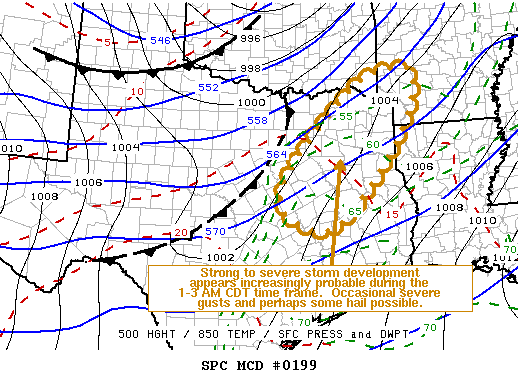
SUMMARY…Thunderstorms may initiate near the Corsicana and Tyler
vicinity by 1-3 AM, with a possible eastward and southeastward
advancing squall line evolving thereafter. This probably will be
accompanied by at least some risk for severe wind gusts, and perhaps
some hail. The extent of this threat remains a bit uncertain, but
it is possible that a severe weather watch may become necessary
later tonight.
DISCUSSION…Within strong, deep-layer cyclonic flow, an embedded
short wave perturbation appears to be providing support for
increasing large-scale ascent, now spreading northeast of the
Edwards Plateau and Hill Country (based on latest water vapor
imagery). At the same time, at least modest boundary-layer based
destabilization appears to be ongoing in a corridor south/southeast
of the Dallas-Fort Worth Metroplex, toward the Ark-La-Tex, where
rapid surface dew point rises into the lower/mid 60s F have been
evident this evening. This is occurring near the nose of a remnant
elevated plume of warm air associated with deep daytime
boundary-layer mixing, emanating from the Rio Grande Valley.
Although the surface-based moistening appears somewhat shallow, it
seems increasingly probable that it will be sufficient to support
increasing thunderstorm development by the 06-08Z time frame. This
may be initially aided by lift enhanced by low-level warm advection,
in the vicinity of a strengthening low-level jet (in excess of 50 kt
at 850 mb) across the Corsicana/Tyler vicinity. Thereafter, model
output, including the convection allowing HRRR, suggests that
low-level frontogenetic forcing may support the rapid evolution of a
narrow squall line.
Any initial warm advection driven storms may be accompanied by at
least some risk for marginal severe hail, given the strong shear and
thermodynamic profiles characterized by substantial convective
instability and CAPE up to around 1000 J/kg. However, strong
surface gusts, perhaps occasionally reaching severe limits, seems
likely to become the primary potential hazard as the line of storms
advances eastward and southeastward across northeastern Texas.


0 Comments