
Our small respite from more active weather is just about over. We’ll start off with thunderstorm chances tonight into Monday morning across Northwest Texas, Texoma, and North Texas. Severe weather is not expected with storms tonight or tomorrow morning, but I can’t rule out a storm producing very small hail. Locally heavy rainfall may occur which won’t make the morning drive pleasant, but flooding isn’t expected.
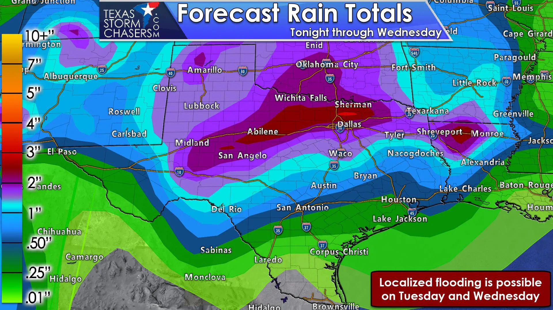
Rain chances beginning Monday night will be highest across the western half of Texas. There is the potential for a few strong storms with hail and gusty winds in the Davis Mountains beginning Monday night. A line of thunderstorms is expected to develop on Tuesday across eastern New Mexico into West Texas. That squall line may extend from Kansas south through much of Texas as it slowly moves east Tuesday night and into Wednesday.
By Tuesday night into Wednesday an area of low pressure in eastern Colorado to Kansas is expected to quickly intensify. The intensification of the surface low pressure will result in a significant uptick in kinetic energy (winds aloft). Those strong winds aloft may mix down to the surface in those storms – increasing the threat of damaging wind gusts. Tuesday and Wednesday will be our primary period for the threat of strong/severe storms and heavy rainfall.
We do note that the low pressure may be one of the deepest (strongest) we’ve seen in quite a long time. Some models have it going below 980 millibars (28.95 inches of mercury). That means very strong winds aloft and the potential for strong to very strong winds at the surface. We could experience a widespread, significant high wind event on Wednesday as skies clear west of a dryline and temperatures warm. We’ll talk about that as we get closer, but the western half of Texas could see wind gusts exceeding 60 MPH at times on Wednesday.
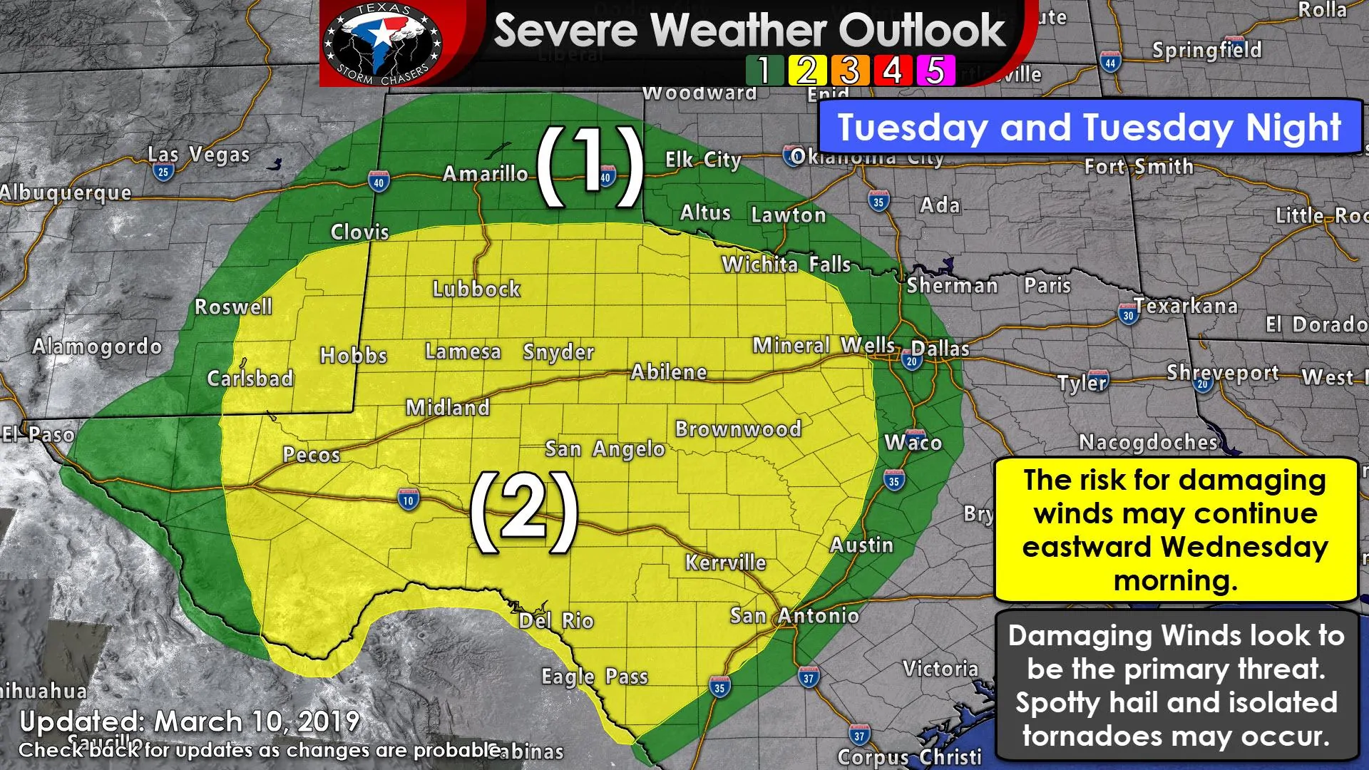
We do have a large geographical region under a severe weather risk Tuesday, Tuesday Night, and Wednesday morning. I anticipate we’ll see the risk zones modified in coming updates as we get a better grasp on instability values. While wind shear is going to be very strong, widespread cloud cover and rain may keep instability values modest.
If the atmosphere is more stable that would help reduce the risk of severe storms. However, I am a bit concerned that the strong winds aloft (over 80 MPH just a few thousand feet above the surface by Tuesday night) may partially make it to the surface even in weak thunderstorms as a squall line moves east. That’s a conditional threat, but it wouldn’t take much to get 50-60 MPH winds mixing down to the surface.
Flooding is not an issue tonight or on Monday. However, after a few days of rainfall, we may start to see some localized flooding issues on Tuesday and Wednesday as soils begin to saturate across the western and northern half of Texas. Hey, we really do need the rain in some of these areas where short-term drought has emerged thanks to several weeks of very dry weather. This won’t be a major flood event, but we’ll keep on watching it.


0 Comments