
Congratulations on making it to Hump Day! Although for my better half (Paige) this is technically Friday in her work schedule, so congratulations on making it half-way through the week or on making it to your weekend. We’re starting off the morning with dense fog across the eastern two-thirds of Texas. We should see the fog burn off pretty quickly after sunrise as temperatures start warming up from morning lows. Don’t use your vehicle’s high-beams, give yourself extra space on the road, and please don’t be a part of a 40 vehicle pile-up. That’s just not the kind of mood we want to project on Hump Day.
A difficult temperature forecast today and tonight

The temperature forecast this afternoon is going to be a tough one for the northern half of Texas. Specifically, the behavior of a shallow slow-moving arctic cold front. We anticipate it will make southward progress throughout the day, but it should stall out at some point tonight. Exactly how far south it makes it is still up in the air. We’re sharing the output from the High-Resolution Rapid Refresh. This model has a high-enough resolution to better handle these shallow arctic air masses, but we note the front may still move farther south than previously anticipated. A push into the central Texas counties by late evening is possible.
Why does it matter where the front ends up? Well… the temperature contrast on either side of the front will be about 40 to 50 degrees over the span of a county. For example, we may end up seeing the northern D/FW metroplex in the 30s this afternoon while Cleburne and Waxahachie are in the 70s. That’s how sharp of a temperature gradient this front is presenting us with. The temperature forecast will also play a bigger role late tonight into Thursday morning as some very light precipitation may occur in portions of North Texas and Texoma. If temperatures are below freezing up on the Red River we could see some freezing drizzle tonight with a few slick bridges. We’ll monitor new data throughout the day and update the forecast as needed.
Rain chances continue today through Thursday
Scattered showers and even a few storms are possible today and on Thursday across eastern sections of Texas. I really think we’re done with the overambitious hailers and two-inch an hour rainfall rates. Overall we’re anticipating more of a steady rainfall versus a sudden downpour/flood situation.
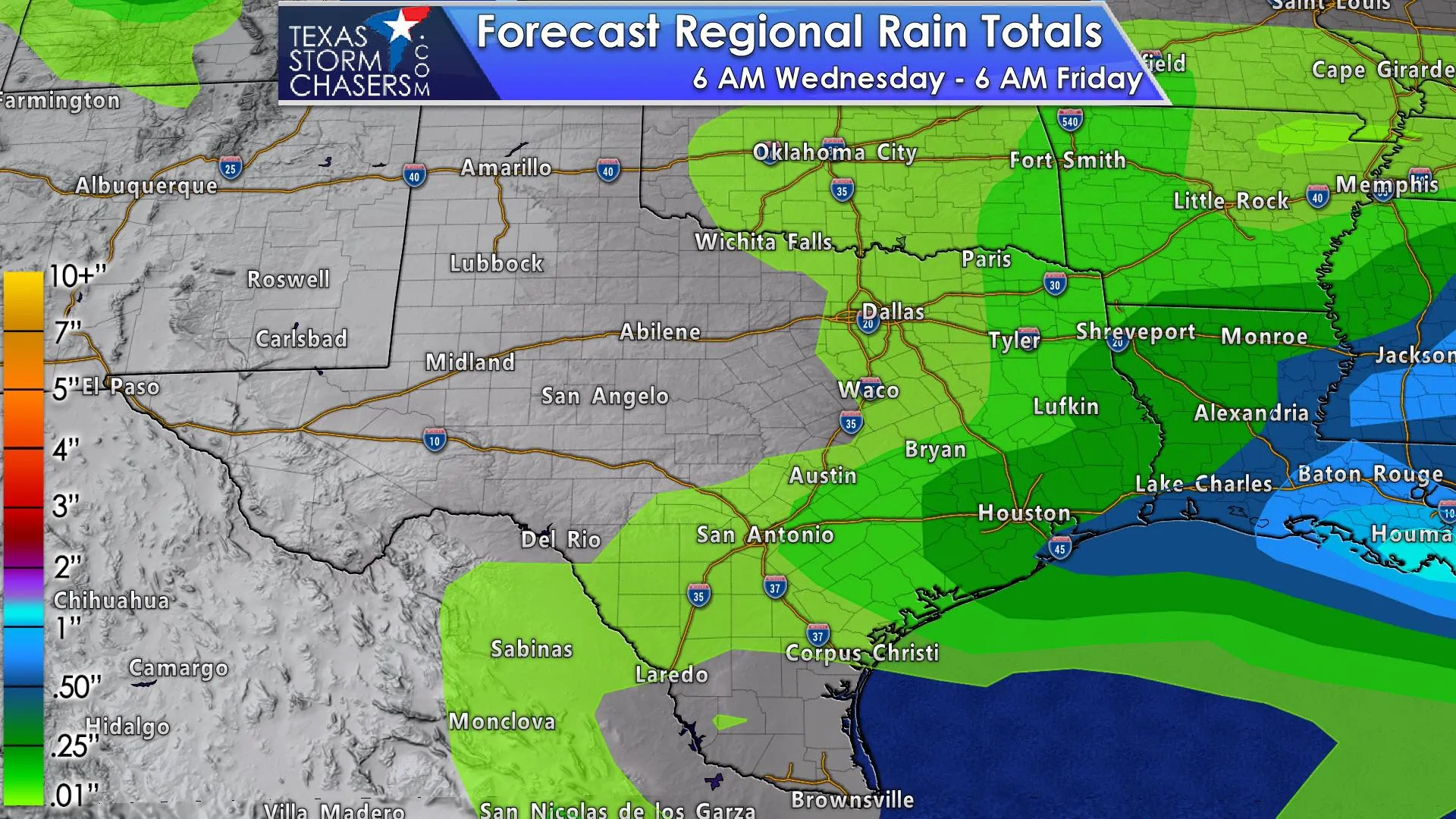
Rain amounts over the next two days will not be too impressive. The highest rain totals across Southeast Texas and East Texas may approach one-half inch with locally higher amounts. These are additional rain totals from today through Thursday night. Amounts drop off to around one-quarter inch across the Brazos Valley and Northeast Texas.
A brief warmup for Thursday and especially Friday
The shallow arctic airmass will be difficult to kick out, but it looks like we’ll finally accomplish it on Friday as strong southerly flow returns ahead of our weekend arctic encounter. Temperatures on Friday look to be quite pleasant with 60s, 70s, and 80s. I wouldn’t be too surprised if this data is a tad too cool with Friday. Enjoy the warmth because by Sunday and Monday temperatures will be 40 to 50 degrees colder.
Big-time arctic outbreak arrives this weekend through next week
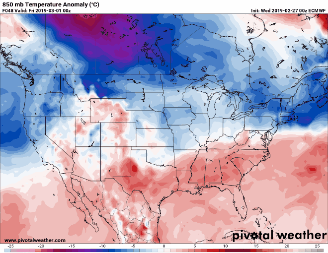
European weather model low-level temperature anomalies from Thursday through Tuesday. This animation is meant to convey the general air mass change, not specific temperatures. Regardless, I believe you’ll get the idea we’re trying to convey.
Confidence is high that an extended period of well-below average temperatures will impact Texas beginning on Saturday and continuing through at least the middle half of next week. These temperatures will be cold even by ‘winter’ standards with temperatures between 20 and 40 degrees below average for early March. This late-season arctic outbreak will impact most of the United States east of the Continental Divide. I’ll let your local weather services (or crappy weather app) provide a temperature forecast, but we’ll undoubtedly begin talking specifics as we get closer.
Cold airmass + precipitation chances = winter mischief?
There are indications that a few weak upper-level storm systems may move overhead while this colder airmass is in place. Confidence in the placement, timing, and strength of those potential systems means we can’t say if there will be winter precipitation or not. We are watching the Sunday-Monday timeframe for some potential winter mischief across the eastern Texas Panhandle, Northwest Texas, Texoma, and perhaps portions of North Texas. That chance could easily not happen at all and I even hesitate to mention it, but some automated weather apps are showing it. It wouldn’t be the first time we’ve had winter mischief in March. We’ll be watching!
A quick epilogue about this week’s weather so far
A forecaster at the National Weather Service in Norman shared this sentiment in their discussion yesterday. “I have tremendous respect for those involved in developing and improving numerical forecast models. It is amazing how far we have come as a science. Some days prove to be particularly challenging for models, however. Today was one of them.” He was referring to the difficulty in model’s resolving the strength of a shallow arctic airmass that invaded the Texas Panhandle and Oklahoma. Several hundred miles south our forecast of scattered to numerous showers evolved into a localized flood and hail event in Southeast Texas – the second day of overperformance on behest of an upper-level storm system. That ‘bust’ was a result of both the Monday and Tuesday storm systems originating from Mexico where there is very limited upper-air network sampling. AKA: We have to guess on the strength of storm systems until they actually move into the United States weather balloon network. Turns out both systems were more potent than weather models were guestimating. Technology has certainly improved over the last decade, but we’ve had multiple examples this week of why humans are still needed in the weather forecasting business. Anyway, enough chit chat about weather models giving out garbage data.


0 Comments