
The next two days will feature above-average temperatures for January and a preview of early spring. With that preview comes the hassle of dealing with morning fog. Some fog may be dense along with low-level overcast. So while it will be warm for January, it may not be the nicest weather to spend outdoors.
Winter is coming… and so is the north wind of doom
Our focus will be on the arrival of a strong cold front with arctic origins. That front will begin pushing into the Texas Panhandle during the afternoon hours on Friday. Temperatures behind the front will drop off into the 30s and 40s with wind chills even lower. This front is going to have the pedal to the metal as strong north/northwesterly winds make for a rude awakening to those unprepared for cold weather.
While the cold front’s timing may change by a few hours (slower or faster) it looks like this front is going to be booking it south. Arrival into Wichita Falls looks to be around 7 PM, the D/FW metroplex around 10 PM, around midnight in Austin, and before sunrise on Saturday in Houston. Wind chills will be in the 10s and 20s across the north/northwestern half of Texas by sunrise on Saturday as strong northerly winds continue. Saturday and Sunday will be chilly to downright cold.
A marginal severe weather threat Friday evening in eastern North Texas and Northeast Texas
Enough moisture, instability, and wind shear should be present Friday night into early Saturday to support the possibility of strong thunderstorms across North Texas, Northeast Texas, and East Texas. At this juncture, I anticipate this will be more of a ‘noisy boomers with small hail and heavy rain’ event versus something higher up on the severe storm chain.
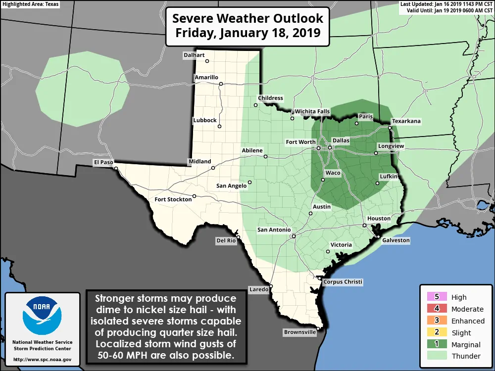
Severe weather outlook for Friday evening into early Saturday.
Colder air aloft should support some small hail with the storms and a few of the more rowdy storms may produce quarter size hail for a time. I’m not convinced we’ll see much of a damaging wind threat, but if storms are able to form right on the cold front’s leading edge versus back behind it in a cooler airmass we may see some higher winds make it down to the surface. Tornadoes are not expected with this event based on the anticipated parameters. It is entirely possible we keep storms entirely under severe limits (a severe storm is one that produces at least quarter size hail and/or wind gusts of 58+ MPH – or tornadoes). Thunderstorms should exit Northeast Texas a few hours before sunrise on Saturday.
Chance of snow on Saturday…
SNOW SNOW SNOW SNOW ITS GONNA SNOW!?!?!
Sorry, but let’s be honest here. Most Texans see the word snow and think the world is going to end. If a Texan sees a snowflake it’s immediately #breakingnews. It’s alright, I’m a big snow weenie myself. However, let me try and let you down easy. You won’t be building a snowman on Saturday. Roads will not turn into an icy mess of doom, and you won’t be getting to use that ruler to measure snow.
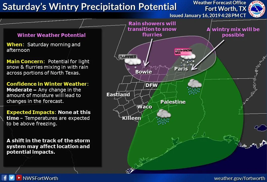
Now that I’ve become public enemy number one and made the children cry let’s actually talk about the chance of some snow flurries on Saturday. We may have just enough moisture and a touch of upper-level lift to generate some light snow in Texoma on Saturday. If we see snow it’s unlikely that we see accumulations at this point. If data were to shift south we might introduce a dusting on elevated objects in later forecasts in places like Shamrock, Vernon, Wichita Falls, and Gainesville. Surface temperatures should be near or just above freezing, so travel impacts would be unlikely in either scenario. Any precipitation – if it happens at all – would depart by Saturday night.
Conclusion and onto the next cup of Coffee
Temperatures won’t be as cold as we originally thought earlier this week, but it’ll still be a chilly weekend across Texas. Temperatures will moderate on Sunday across the western half of Texas, but cold air advection will keep things on the cold side across North Texas, Central Texas, extending northeast through East Texas. We’ll get a few days of downtime before our next upper-level storm system arrives on Tuesday.


0 Comments