
The severe weather forecast for Wednesday and Wednesday night remains a bit of a confusing one, but let’s see if I can’t help answer some questions. First off, we now have an official severe weather outlook drawn up from the Storm Prediction Center. They use a five-level system with one being the lowest and five the highest. Those in a level one risk have about a five percent chance of severe weather within 25 miles of their location. Those in the level two risk have a fifteen percent chance of severe weather within 25 miles of their location. Severe weather is defined as quarter size hail or larger, wind gusts of 58 MPH or higher, and tornadoes.
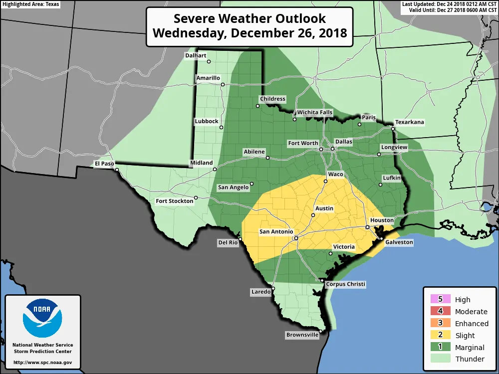
Wednesday’s severe weather outlook from the Storm Prediction Center
The western edge of the level one risk across the eastern Texas Panhandle south into the eastern Permian Basin could begin by the early afternoon hours on Wednesday. This aspect of the forecast will greatly depend on if we see showers/storms fire up in the morning hours or if they hold off until the afternoon. If we see them wait until the afternoon and get some clearing the threat of severe weather would be higher. Otherwise, the atmosphere would still support the possibility of some hail and localized high winds with storms in the morning and afternoon.
Showers and thunderstorms may be ongoing across the remainder of the outlook area through the day Wednesday. This would actually tend to limit a higher-end severe weather threat by not allowing the atmosphere to destabilize. That is the general assumption of this outlook issuance. By the early evening hours Wednesday we anticipate an uptick in thunderstorm activity and intensity from Northwest Texas south through the Big Country into the Concho Valley and Hill Country.

Thunderstorms may tend to grow upscale into a squall line fairly quickly. This squall line would move east fairly quickly Wednesday night and impact the eastern half of Texas. The northern edge of the instability axis – or the line where the atmosphere becomes unstable enough to support stronger storms – will play a big role in determining higher zones of severe weather potential Wednesday night. I want to emphasize that this will be a night-time event for most and storms are going to be booking it at 45+ MPH.
The level two risk issued by the Storm Prediction Center includes the Edwards Plateau, Hill Country, Central Texas, Brazos Valley, and Southeast Texas. Those regions look to have the best chance of having an unstable airmass combine with very impressive kinematics (wind shear) Wednesday night. As the squall line races from west to east, we anticipate the stronger storms in the squall line will pull the stronger winds aloft down to the surface. That downward momentum would allow for wind gusts of 50 to 70 MPH in stronger storms. There would also be the threat of brief tornadoes on the leading edge of the squall line where embedded supercelluar structures existed.
As you move to the north the instability values decrease. It looks like we may have borderline-NIL instability across North/Northeast Texas north of Interstate 30 Wednesday night, but wind shear values are going to be off the charts. That means even there we may see some higher winds make it down to the surface as the squall line races through and perhaps a brief tornado.
A heart to heart…
December 26, 2015, featured much more impressive moisture values and thermodynamics (instability). In addition, storm mode was discrete versus Wednesday’s expectation of a linear mode (squall line). This event does not compare to December 26, 2015. Can we rule out tornadoes on Wednesday? No. Am I expecting a repeat of December 26, 2015? No. However, if you end up with 70-80+ MPH winds on Wednesday night from straight-line winds or a weak tornado then it will be your December 26, 2015. Pay attention to the forecasts and plan on having a way to receive weather warnings Wednesday evening and Wednesday night.
I’m not exactly sure what my posting schedule will be for the next two days given the holiday. I’ll endeavor to post an update sometime tonight since we’ll have our first look at high-resolution weather model data for Wednesday. You can get the latest weather information by visiting the National Weather Service and following your favorite local broadcast meteorologists. Oh yeah, we have a revamped mobile app that can be used to keep up with us too!


0 Comments