
Good morning and welcome back to the wonderful world of weather. Sorry, I’m up a bit past my bed-time and have had a little too much coffee this morning. Most of you reading this are undoubtedly not looking forward to our upcoming winter weather and heavy rain threats. Our upcoming system has been showing up in weather model guidance for well over a week. However, that does not mean this is an easy event to forecast. In fact, there are a few factors making for a particularly difficult winter weather forecast. The heavy rain aspect is not as difficult, but it also has a few questions that still need answers. Let’s dive into it! If you’re interested in the heavy rain and flooding aspect of the forecast please scroll down past the winter weather discussion.
Winter Weather Discussion

A major winter storm is expected to bring significant impacts to much of the Texas Panhandle, West Texas, West-Central Texas, and Northwest Texas on Friday and especially Saturday. The National Weather Service offices in Amarillo, Lubbock, and Norman (OK) have hoisted winter storm watches for a majority of their county warning areas. A winter storm watch is a ‘heads up’ that it is time to prepare for a significant winter storm. In particular, we’re concerned about heavy snow accumulations and the potential for an ice storm where an axis of freezing rain develops.
Today should be mostly dry across the aforementioned regions. We could see a few sprinkles or even a sleet pellet or two, but the main upper-level lift is not expected to arrive until late tonight or into the morning hours on Friday. Overnight model data has slowed the storm system down a bit, so we may be able to push these start times back by a couple of hours. One significant uncertainty is on the extent of the cold air at the surface as precipitation begins. That ‘freeze’ line will dictate who starts off right away with winter precipitation and who might get a bit of rain before switching over to the wintry mess. That process will take place as the transition line moves south on Friday and Friday night.
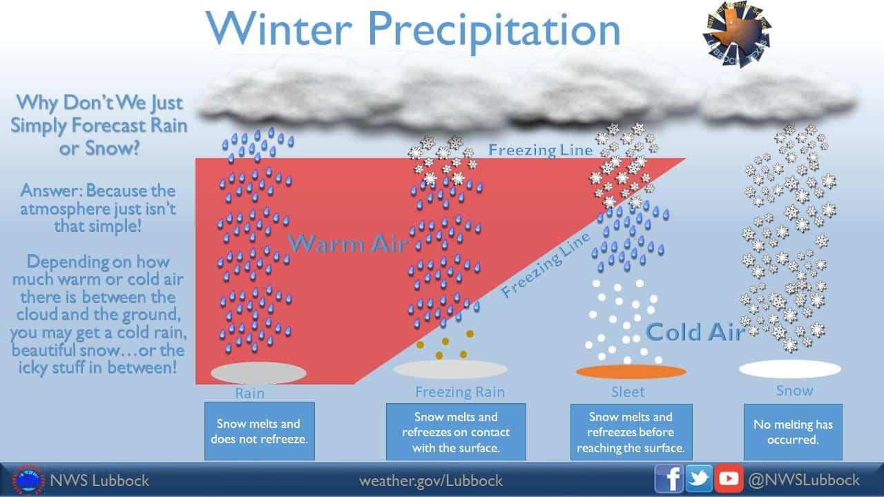
Another question is the possibility of a ‘warm nose’ or a layer of warm air around 3,000 to 5,000 feet above the surface. That layer will have temperatures in the upper 30s and 40s – enough to melt snow back to liquid rain. As that rain falls back into the sub-freezing airmass just above and at the surface it could either a) refreeze into a sleet pellet if the layer of sub-freezing air is deep enough, or b) hit the surface as a super-cooled liquid rain drop and freeze instantly on contact with exposed objects (freezing rain). Eventually, colder air will move in from the north and eliminate the warm-nose. That’s when freezing rain and sleet would transition to all snow. That process should occur fairly quickly across the Texas Panhandle but will take longer farther southeast.
We’re still 24-36 hours away from this event beginning and a good 48-60 hours away from when we anticipate the peak of the winter storm will be underway. That means the accumulation forecast is still very uncertain. I guarantee there will be changes to overall totals and there will be changes on where those heavier totals fall. Forecasting winter weather in Texas is difficult enough inside 24 hours, and we are likely going to have a few surprises even when the event is already beginning. We anticipate a swath of 6-10″ snowfall totals across the eastern Texas Panhandle extending into Oklahoma. Snow totals will decrease with southward extent with several inches possible across all of West Texas.
A big concern is also the risk of an ice storm across parts of West-Central and Northwest Texas. Anything over one-quarter inch qualifies as an ice storm – and when you get closer to one-half inch we get very worried about tree and utility infrastructure damage. That ‘ice’ corridor will set up just southeast of the snow line, so we’ll have to refine that location today and tomorrow. The winter storm will come to an end from west to east Saturday evening. We do note that there is a chance of a rain/snow mix farther south and east across the Permian Basin, Big Country, into North Texas on Saturday. At this point, accumulations don’t look likely, but we’ll keep monitoring data in case it trends colder and slower with the upper-level low (slower would give a higher chance of some snow).
Regardless of snow, sleet, or freezing rain – each accumulation would result in hazardous travel conditions now only while the event is underway, but continuing through Sunday and perhaps Monday as temperatures will remain below freezing into early next week.
Heavy Rain and Flooding Discussion
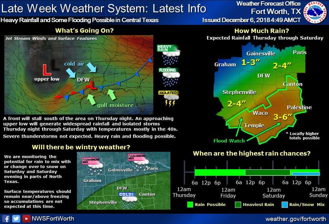
We’ll see rain chances move into the ‘likely’ category tonight across the southeastern two-thirds of Texas. Some of this activity may begin producing heavy rain tonight into Friday morning, but the higher potential for flooding shouldn’t begin until we’re into Friday afternoon and Friday night. Friday and Saturday are going to be wet across the entire state of Texas. It doesn’t matter if you’re in El Paso, Amarillo, Austin, Brownsville, Houston, or Texarkana.
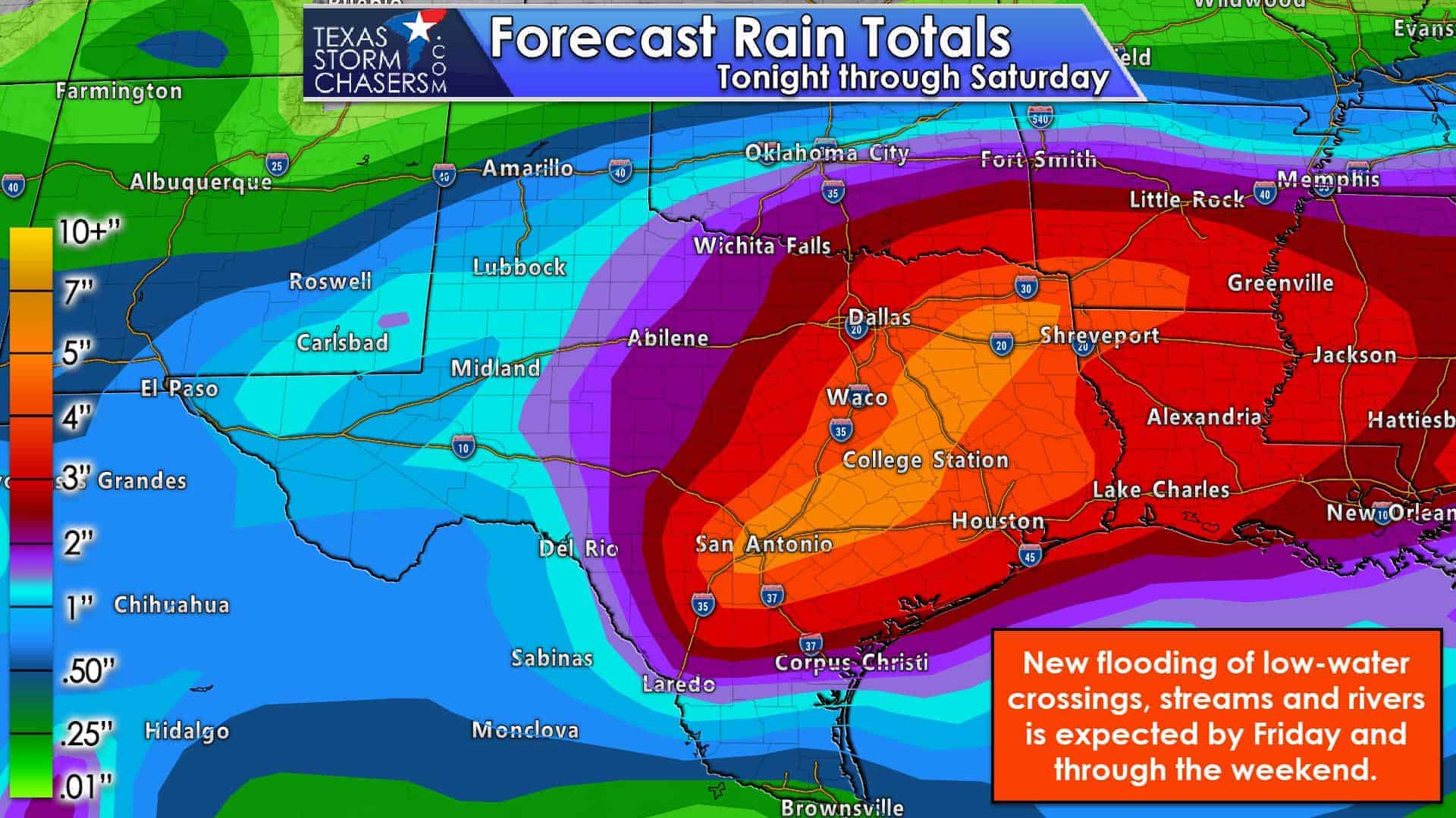
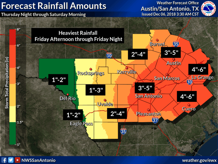
The most likely time for widespread heavy rainfall and an uptick in flooding will be Friday afternoon through Saturday morning across South-Central Texas, Central Texas, the Brazos Valley, East Texas, and Southeast Texas. Those regions are in the bullseye for widespread rain totals of 3 to 6 inches. We note that localized rain totals will be higher, and someone may end up measuring 8 to 10 inches of rainfall. Soils are saturated, most surface vegetation is dormant for the winter, and the ground is cool/cold. Most rain that falls in the coming days will not be absorbed by the ground. It’ll run off into streams, rivers, and eventually lakes. All of that will result in a new round of flooding, with a fairly substantial flash flooding risk possible by tomorrow night. It will take several days if not a couple weeks for all this new water to pass through the various watersheds and out into the Gulf of Mexico.
Rain chances will begin ending from west to east on Saturday into Saturday night as our upper-level storm system and associated surface low eject northeast. River flooding will continue through next week.
Summary and Housekeeping
We’re not expecting any major forecast changes through the morning hours. National weather service offices across the state will analyze morning model data and have their new forecasts out between 3 PM and 5 PM today. I anticipate we’ll see the winter storm watches upgraded to various warnings (winter storm, ice storm), and we’ll also have the latest on both winter and rainfall accumulation forecasts. Hopefully, the upper-air network will fully sample our storm system this morning since it is now on-shore out on the west coast. That should help models come into better agreement on how our weather will play out over the coming days. Our next detailed update should be posted by 5-6 PM – and I am planning on producing various video updates on our social media platforms throughout the day. Have a good day and please check back for forecast updates this evening and several times on Friday and Saturday.


0 Comments