
A new tornado watch has been issued for East Texas through 4 AM. This is to cover the squall line from near Paris to Canton to Waco. This squall line is moving east at a decent clip with storms moving northeast at around 50 MPH. Most storms have been behaving tonight, but very strong wind shear remains in place.
We may see some destabilization occur ahead of the squall line in East Texas in the coming hours as temperatures aloft cool (while surface temperatures may actually warm a few degrees). A widespread severe weather threat is not expected tonight, but we’ll have to watch storms ahead of the squall line along with embedded stronger storms in the squall line. Localized damaging wind gusts and isolated brief tornadoes will be possible. Heavy rainfall is occurring with all storms tonight and that may result in localized flooding.
We’re also watching storms across Central Texas into the southeastern Hill Country. These too are behaving for now, but we can’t rule out an isolated severe weather threat overnight as those storms move east into the Brazos Valley. Heavy rainfall and localized flooding is also a threat there.
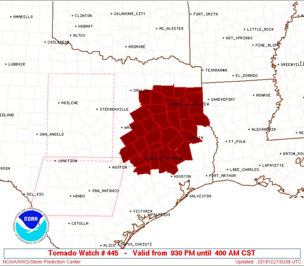
 Tornado Watch Number 445
   NWS Storm Prediction Center Norman OK
   930 PM CST Wed Dec 26 2018

   The NWS Storm Prediction Center has issued a

   * Tornado Watch for portions of
     East-Central Texas

   * Effective this Wednesday night and Thursday morning from 930 PM
     until 400 AM CST.

   * Primary threats include...
     A couple tornadoes possible
     Scattered damaging wind gusts to 70 mph possible

   SUMMARY...As some additional warming and moistening occurs, isolated
   storms could intensify late this evening/overnight ahead of an
   eastward-moving convective line and cold front. While a particularly
   widespread severe risk is not expected, adequate
   moisture/instability exists in the presence of very strong
   deep-layer/low-level shear for the possibility of damaging winds and
   a tornado risk.

   The tornado watch area is approximately along and 65 statute miles
   east and west of a line from 25 miles north northeast of Tyler TX to
   20 miles south southeast of College Station TX. For a complete
   depiction of the watch see the associated watch outline update
   (WOUS64 KWNS WOU5).

   PRECAUTIONARY/PREPAREDNESS ACTIONS...

   REMEMBER...A Tornado Watch means conditions are favorable for
   tornadoes and severe thunderstorms in and close to the watch
   area. Persons in these areas should be on the lookout for
   threatening weather conditions and listen for later statements
   and possible warnings.


0 Comments