
An extended period of active weather will bring a variety of potential impacts over the next week. Severe thunderstorms, heavy rainfall resulting in flash flooding, and the longer-term issue of river flooding all look to be on the table. The threat for stronger thunderstorms will become the first threat to materialize beginning tomorrow.
The Storm Prediction Center has placed a marginal risk of severe weather across the Texas Panhandle and West Texas for Thursday afternoon. Tomorrow’s strongest storms could produce localized damaging wind gusts and some hail. The parameters aren’t overly impressive for damaging hail tomorrow and cloud bases should be too high for a tornado threat. Similar threats may materialize again on Friday during the late afternoon and evening hours.
A strong cold front will bring much cooler conditions to the Texas Panhandle and West Texas Friday Night into the first half of Saturday. That cold front will stall across Northwest Texas and into the Big Country, and begin to move back north as a warm front Saturday night. The exact location of where the front stalls are still up in the air, so it may end up making more southward progress than the graphic above indications.

Regardless, the front should begin moving north Saturday night into Sunday. As it does so we’ll see higher moisture values and a more unstable airmass advance northward as well. This brings us into Sunday. There are plenty of uncertainties as medium-range models are impressively divergent on their solutions. One model suggests widespread rain and clouds will keep the atmosphere comparatively stable. A second model shows less rain and fewer clouds with an unstable airmass overlaid with strong wind shear. The first model would result in a localized severe weather threat on Sunday in the eastern Texas Panhandle and West Texas. The second model would likely result in a regional severe weather event with all modes of severe weather in the same locations. The fall severe weather season has arrived.
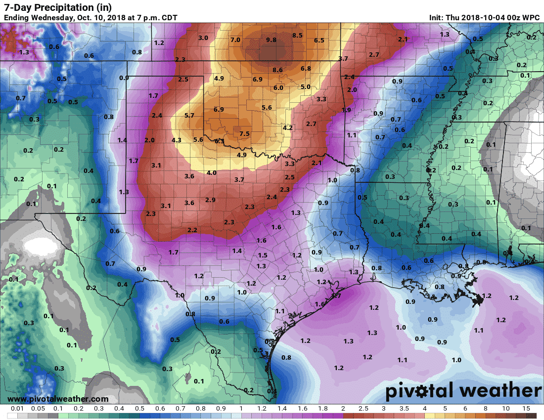
Potential rain totals over the next seven days. These will change as the forecast is refined.
Of greater concern is the increasing likelihood of widespread heavy rains and associated flooding potential. Unlike most flooding events since late 2015, this one will actually be focused farther west and north. The seven-day potential rainfall forecast from the Weather Prediction Center (WPC/NOAA) has a bullseye of 4 to 8 inches across the eastern Texas Panhandle, Northwest Texas, into Texoma. Even higher rain totals are possible farther north across Oklahoma and southern Kansas. The axis of highest rain totals and the eventual numbers will change as data is refined, but while both model solutions I mentioned earlier are divergent in their severe weather risks, both are showing this heavy rain solution. This could begin as soon as Saturday, but is more likely to be well underway by Sunday Night into Monday, Tuesday, and Wednesday. Flash flooding will be a threat where heavy rains cause rapid accumulations, but we’ll also have to watch for increasing river levels.

This slow-moving and potent upper-level storm system will continue to bring both a heavy rain and potential strong thunderstorm threat into next week. The threats will slowly shift each by Monday and Tuesday.


0 Comments