
A cold front will bring an end to our warming trend tomorrow and on Wednesday. Unfortunately, this front, and a developing surface low will also bring showers and thunderstorms on Halloween. Current data suggests the cold front will push through the Texas Panhandle tomorrow afternoon. It’ll push south through the Permian Basin, Big Country, and North Texas tomorrow evening, and into Central Texas, the Brazos Valley, and East Texas Wednesday morning. By the late afternoon on Wednesday the front should be from near Eagle Pass to Victoria to Houston to Jasper. Temperatures north of the front will be int he 40s and 50s (with wind chill values several degrees cooler). It’ll be warm and muggy south of the front with temperatures in the 70s and 80s on Wednesday. The initial surge of cooler air with the front will only be within the first couple thousand feet above the surface. Above that will be a warm and unstable airmass – supporting showers and storms behind the cold front (as well as along it).
Rain Timeline for Halloween
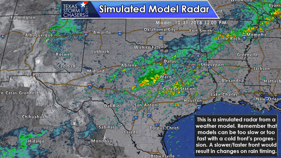
Convection is a pretty good bet on Wednesday as the cold front marches to the south across Texas. These rain chances will be in association with the front and in the residual airmass behind the front. Unfortunately, that means a rather unpleasant Trick or Treat forecast for parts of the state. With that in mind, we’re going to focus on the Wednesday evening time-frame for specific rain chances. The North American Model (NAM) is a decent short-range model and is what generated the above forecast radar images. This morning’s model run has showers underway at 6 PM on Wednesday across Central Texas, South-Central Texas, the Brazos Valley, Northeast Texas, East Texas, Southeast Texas, and moving into South Texas towards Corpus Christi. The heaviest rains at this juncture would likely be from Central Texas eastward into East Texas and Southeast Texas. Some of these storms may be severe (see the section below for details). Localized flooding is also possible. Rains will end from northwest to southeast Wednesday night into Thursday morning as the cold front continues to push south and east. Temperatures will be noticeably cooler on Thursday and Friday as drier airmass filters in from the north.
Severe weather outlook for Wednesday and Wednesday evening
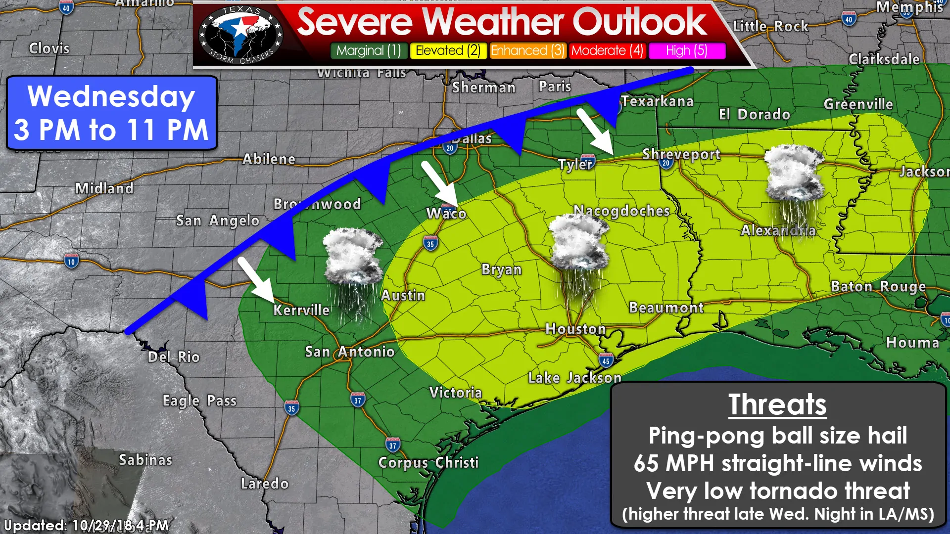
A level two risk of severe weather is in place for Wednesday across Central Texas, the Brazos Valley, East Texas, and Southeast Texas. This zone has a 15% chance of severe weather occurring within 25 miles of a given point (like your location). A level one risk of severe weather is in place across South-Central Texas, the Coastal Plains, the Middle Texas Coast, Hill Country, the southeastern half of North Texas, and in Northeast Texas. Those in this marginal risk have a 5% chance of severe weather within 25 miles of a given point (like your location).
Wednesday’s severe weather setup is one that favors a linear storm mode. That is, we anticipate thunderstorms to be orientated in line segments versus them being discrete or out by themselves. With the strongest storms on the leading edge of the cold front, we may have straight-line winds up to 65 MPH and hail up to the size of ping-pong balls. Not all storms will be that strong, but all storms will produce dangerous cloud to ground lightning and gusty winds. We’d like to remind everyone that gusty winds do not mix well with outdoor decorations.
Thunderstorms are also possible behind the cold front in the unstable elevated airmass. A few storms behind the front may be capable of producing quarter to half-dollar size hail. Both of these scenarios do not favor much of a tornado threat, but we can’t rule out a brief tornado if any storms get rowdy ahead of the cold front and as a surface low begins to take shape over East Texas Wednesday evening. This surface low will result in a comparatively higher tornado threat into the early morning hours Thursday across Lousiana into Mississippi.
Rainfall and Flooding Outlook
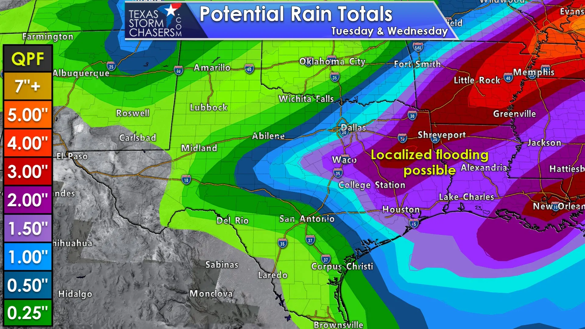
Thankfully the heaviest rains from the Halloween system are expected to be east of Interstate 35 and generally higher east of Interstate 45 in East and Northeast Texas. This will reduce (but not eliminate) the chance of new flooding across the Concho Valley, Hill Country, and those along and east of Interstate 35 in North and Central Texas. Of course, if we have one to three inches of rainfall in an hour that point will be moot since there would be flash flooding. The threat of localized flash flooding and river flooding will be higher in East Texas and Southeast Texas with the possibility of 1.5 to 4 inches of rain on Wednesday. We’re still a couple days out so expect some overall changes and refinements to all aspects of the forecast.


0 Comments