
Rise and shine because Friday has arrived! That saying used to mean more to me when I didn’t work seven days a week, or when my ‘weekend’ started on a Monday. Anyway, it is indeed someone’s Friday so congratulations on surviving another work week! I wish I could share some good news in the weather department, but I’m afraid mother nature (and a bit of El Nino) have different plans.
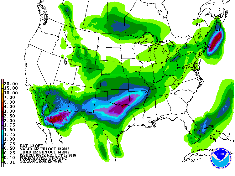
Potential rain total forecast from the WPC/NOAA for 7 AM today to 7 AM Sunday.
It looks like we’ll be starting off the rain a bit early as a weak ripple of atmospheric energy moves across Texoma and North Texas this morning. Severe thunderstorms and overly heavy rain are not expected with this round. Still, some folks may get a quick one-half to one inch of rain. Add that with metroplex traffic and you’re just setting the stage for unpleasantries. The coverage of rain should be on the decline by 2-3 PM, but isolated to widely scattered showers may continue through the day across the Big Country, North Texas, and East Texas.
What was Hurricane Sergio in the eastern Pacific made landfall as a tropical storm in Baja California overnight. This system will lose a majority of its wind component as it quickly traverses northeast through Mexico today. However, it’ll still have plenty of energy and moisture to work with when it arrives in the Borderland tonight.
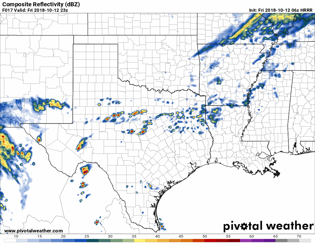
1 AM HRRR model simulated weather radar from 6 PM CT to 11 PM CT tonight
Rain is expected to rapidly increase in coverage after 6 PM MT/7 PM CT across the Borderland and into the Trans-Pecos. The High-Resolution Rapid Refresh (HRRR) model from 1 AM gives El Paso a quick one to two inches of rain this evening – a decent dose of rain for that far west. By midnight the center of circulation with Sergio (which may still be a tropical depression) looks to be about 30 miles south/southwest of El Paso.
Severe weather outlook for tonight into the pre-dawn hours Saturday.
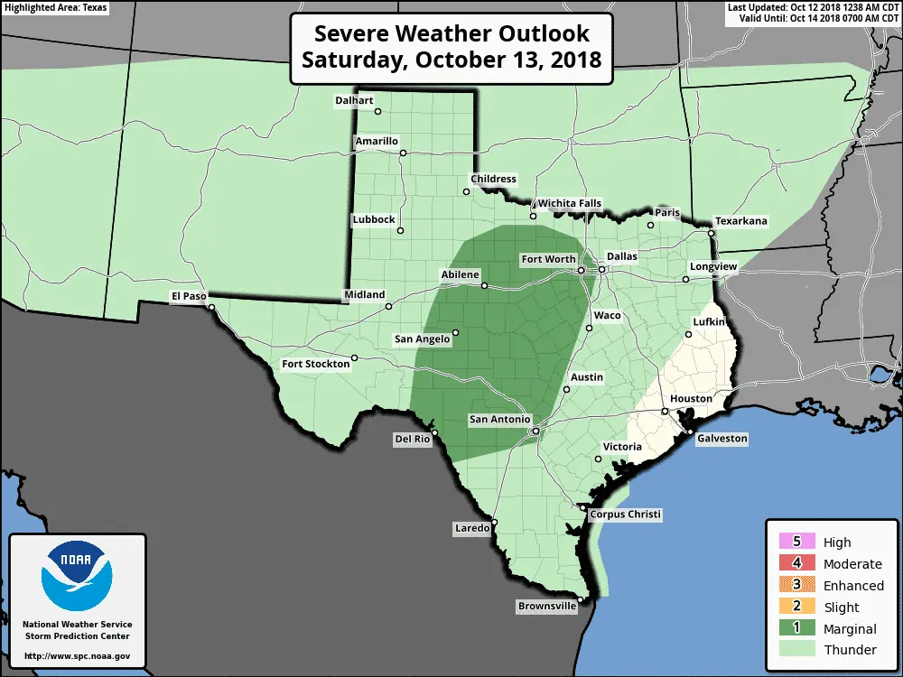
Severe weather outlook for Saturday (7 AM CT onward)
Increasing low-level wind shear and modest amounts of instability may allow for a marginal severe weather threat to develop this evening in the Borderland and Trans-Pecos, but more likely across the Permian Basin tonight. Wind shear values are certainly more than supportive for organized thunderstorms in the Permian Basin towards the western Concho Valley overnight into the early morning hours Saturday. What is questionable is instability values (how unstable will the atmosphere be) and will we actually see a more supercelluar or strong line of storms materialize during the overnight hours? If it becomes apparent that is an increasing possibility you can expect the severe weather outlook to be upgraded in future updates. Localized damaging wind gusts, large hail, and isolated tornadoes would be possible with the strongest storms late tonight.
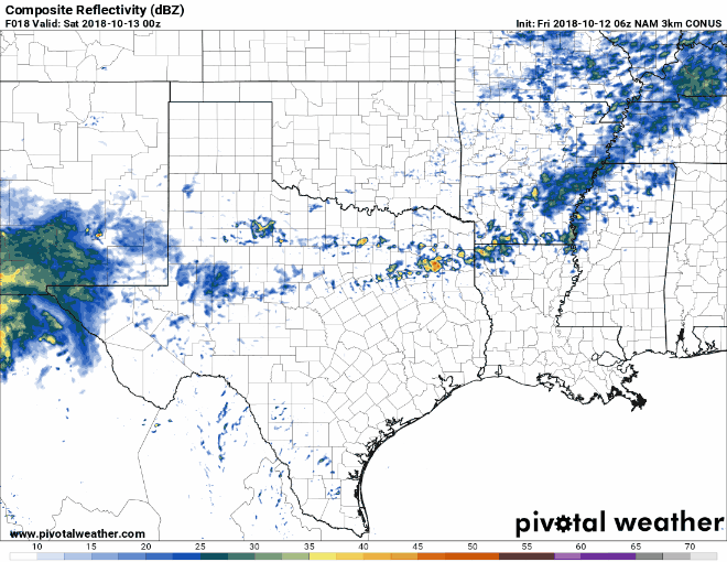
Simulated weather model radar from the 1 AM CT North American Model (3km NAM) run from 7 PM CT tonight through 7 PM CT Saturday.
As the circulation of Sergio continues to track east/northeast tonight and into Saturday so will the area of highest rain chances. Tropical moisture across the eastern two-thirds of Texas will promote widespread rain and thunderstorms. That’s bad news for Saturday events across Texoma, North Texas, and Northeast Texas. Some risk for stronger thunderstorms may exist, but that will be dependent on the position of a stationary front along with atmospheric instability. The simulated weather model radar shown above is depicting a more linear/squall line versus a ‘blob’ of rain. That line would have the threat of some gusty winds and brief tornadoes (much like earlier this week in Central Texas). However, the severe threat is far from certain and will be yet another forecast aspect we refine with future updates later today.
While not mentioned in too much detail, recent heavy rains have many locations unable to take too much rain without runoff becoming an issue. Localized flash flooding is expected to be a threat over the next two days – and probably an increasing threat with next week’s system. Be mindful of low-water crossings over the coming days and be especially careful if out driving at night when you might not see a flooded road until its too late.
We’ll be done with ‘Sergio’ tomorrow night as it moves to the northeast of Texas, but our active weather pattern will only become more interesting as we move into Sunday, Monday, Tuesday, and beyond. We’ll talk more about that extended range forecast in a separate blog later today. You can read our thoughts on it from our blog post last night.


0 Comments