
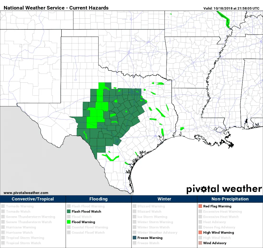
Flash flood watches are back in place across the Edwards Plateau, Concho Valley, Big Country, eastward into Central Texas and North Texas from Interstate 20 southward. One can also see the plethora of flood warnings in place for rivers and lakes that are into flood stage. Given antecedent soil moisture most locations across the flood watch simply cannot take any more rain. Whatever falls will run off and will result in quick responses in streams and rivers. Understand that even a quarter to one-half inch of rain in these conditions could result in renewed or additional flooding.
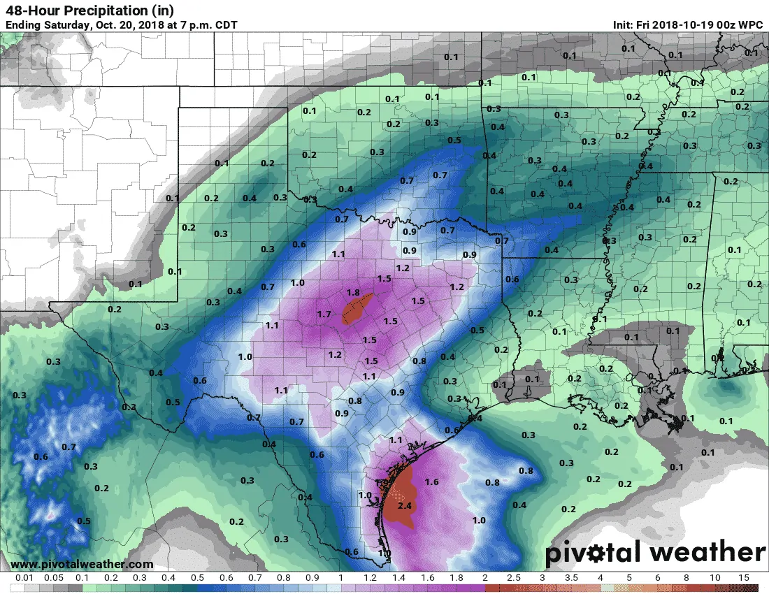
Potential additional rain totals from tonight through Saturday afternoon (most falling on Friday).
The latest rain forecast from the Weather Prediction Center has a broad swath of one-half to one and a half rain totals across the flood watch zone through Saturday. A good portion of this will fall late tonight through the afternoon hours on Friday. These graphics are regionalized, meaning some will see less and some could see more over local zones.
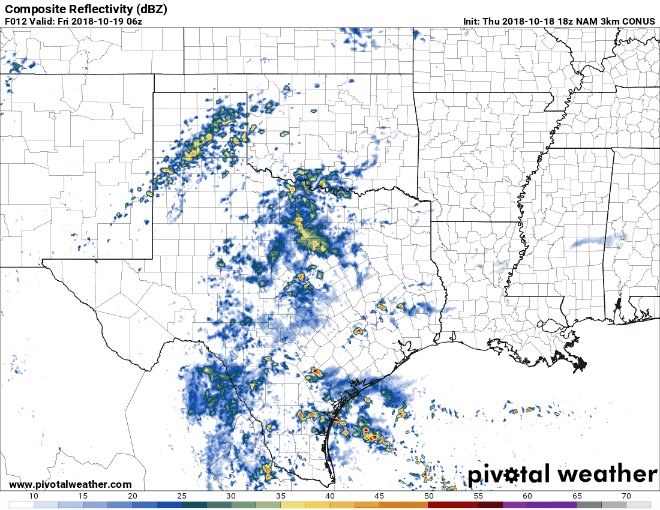
Simulated weather model radar late tonight through Friday afternoon.
There is some uncertainty regarding rainfall amounts with our system tomorrow. Some weather model guidance is suggesting drier air may mix in and help keep rainfall totals a bit lower. I doubt we’d have any objections if that were to verify. However, atmospheric conditions will support the possibility of localized rain totals of 3-4 inches tonight into tomorrow in the flood watch zones. That kind of rain would cause significant rises in streams and rivers very quickly within that area and downstream. Those located near some of the more heavily-impacted river basins from rains over the last week need to be very mindful of any ongoing rains in or upstream of their location. As we’ve seen clearly demonstrated this week we’re seeing very rapid rises in rivers and lakes whenever new rains fall.
Heavier rains should come to an end from west to east during the late afternoon and evening hours tomorrow. Lighter rains will likely continue, but these should not be heavy enough to cause new flooding (but they may result in a slower drop in water levels)
A brief break before a renewed threat of heavy rain and flooding beginning Tuesday Night
The good news is we expect a break from the widespread moderate to heavy rainfall this weekend through early next week. That’ll provide a couple of days of respite, but I’m afraid the break won’t last. Weather model data is already indicating our next precipitation event will begin Tuesday night and could continue toward the end of the work week. Any rain from that event will run-off (as soils will still be saturated) and cause new flooding. There is the potential that an eastern Pacific hurricane could add additional moisture to this event. Since that storm hasn’t even formed yet we’ll just keep that in the back of our mind for now. Pacific hurricane influence or not – additional heavy rains will likely bring a renewed threat of flooding with the system mid-next week.


0 Comments