
One day after a historic Michael brought catastrophic damage to the Florida Panhandle, inland up into the Carolinas, we now shift our focus back to Texas. For our next weather-maker, we must jump over to the Pacific basin and Tropical Storm Sergio. That system is flying northeast toward Baja California where it’ll make landfall early on Friday. It’ll weaken once it moves inland into Mexico on Friday as it continues moving northeast. By late tomorrow Sergio will no longer be a tropical cyclone as it nears El Paso, but it will remain an area of low pressure. Southerly winds in the lower levels of the atmosphere tomorrow will pump in moisture across much of Texas.
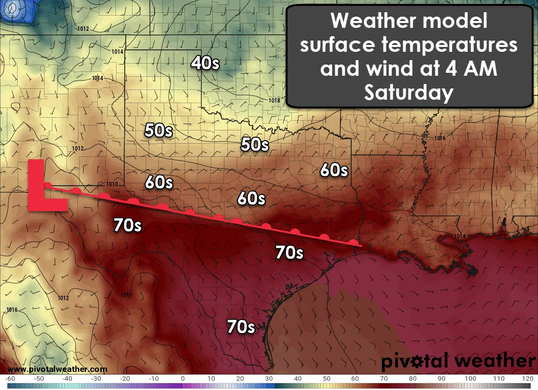
A shallow cool front is expected to be located generally from the Permian Basin east through the Concho Valley and toward East Texas overnight Friday into Saturday morning. This front should become stationary tomorrow night and may attempt some slow northward movement on Saturday as a warm front. Temperatures north of the front will generally be in the 50s to lower 60s with temperatures in the 70s south of the front. This shallow front will only impact temperatures the lowest one to two thousand feet above the surface. Above this cooler airmass will be plenty of tropical moisture.
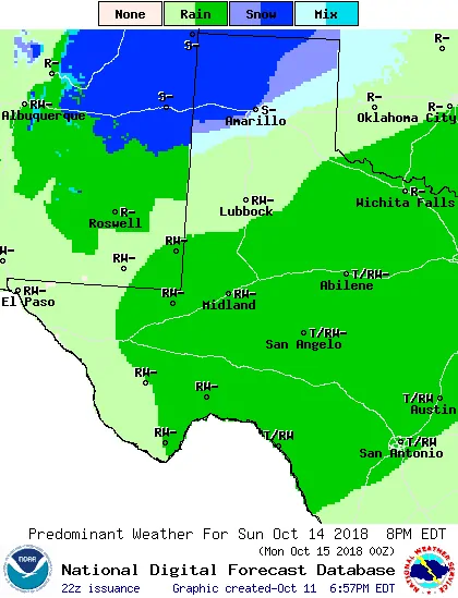
Friday
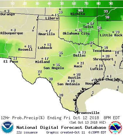
Chance of rain/storms on Friday
Showers and a few thunderstorms are possible during the day Friday across the Permian Basin, Concho Valey, east/northeast into North Texas and Northeast Texas. Up to one inch of rain may fall during the day in some locations who end up receiving heavier rains. Projected rainfall amounts tomorrow should not cause widespread flooding, but recent rains may not allow for much soil absorption – resulting in runoff.
Friday Night
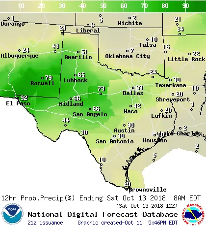
Chance of rain/storms Friday Night
Widespread showers and thunderstorms are expected to begin in earnest Friday Night across the Borderland, east through the Trans Pecos, into the Permian Basin, Concho Valley, Big Country, West Texas, and the southwestern half of the Texas Panhandle. Some locations may receive up to two inches of rain Friday night, especially from the Borderland east into the Permian Basin.
Saturday and Saturday Night
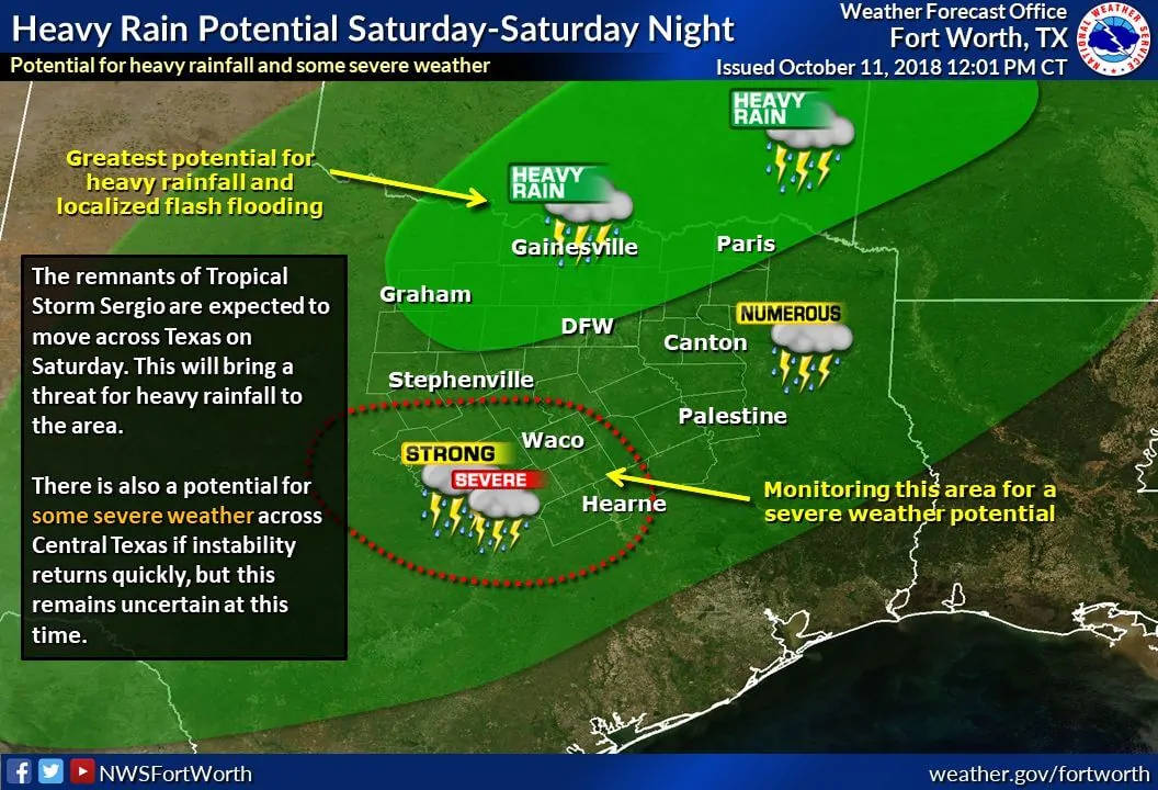
Very high rain chances will spread north and east into Saturday as the remnants of Sergio spread into more of Texas. The possibility of heavy rain and flooding could increase during this period as well with localized rainfall totals of 2 to 3 inches possible across the Big Country and North Texas. Not everyone will see those heavy rain totals, but it won’t take much rain to cause runoff and localized flooding.
The heaviest rain totals on Saturday will probably be in conjunction with the aforementioned weak stationary front. It may make some northward progress on Saturday as a warm front. Questions remain on how far north it may move, but it isn’t out of the question for it to be along a San Angelo to Waco line by Saturday evening. Some risk of severe thunderstorms may develop near and south of the front on Saturday in Central Texas, but this is not something we can pin down too much at this time range.
As the remnants of Sergio begin to exit Texas to the northeast Saturday Night and early Sunday the north/northwesterly flow behind it will help drag a very strong cold front southward. This front will be similar to those we’d expect in November or the winter months, not early to mid-October. An upper-level storm will be entering the region around the same time on Sunday.
Accumulating snow possible in the Texas Panhandle on Sunday
Specifically, our interest on Sunday will be on the timing of the cold front and associated potential of winter precipitation in the Texas Panhandle. Weather model data continues to trend colder (not too surprising considering strong cold fronts usually do plow south fast). Timing and the overall forecast will undoubtedly be refined in the coming days, but here’s what the National Weather Service in Amarillo shared in their afternoon forecast discussion:
Cold front expected to make its move late Saturday night and Sunday, with chances for accumulating snows Sunday and Sunday night. Northwest sections expected to cool enough early for an all-snow precipitation type Sunday morning. A transition zone of rain/snow expected to advance southeast across the forecast area Sunday and Sunday night. The far southeast Texas Panhandle is expected to stay all liquid. At this point, snow totals of 2 to 6 inches look to be possible across northwest sections, generally west of a line from Guymon to Dalhart. East of this line, amounts up to 2 inches have been forecast. Areas east of a line from Canadian to Amarillo to Hereford look more likely to have totals below one inch. Cold weather expected through Monday night, with a hard freeze likely Sunday night and Monday night across the northwestern 2/3 of the Combined Panhandles.
Depending on the cold front’s timing along with precipitation, there is some potential that the ‘mix’ line may continue farther south into West Texas and toward Northwest Texas. At this time accumulations are not expected in those regions even if there was a rain/snow or complete switchover to snow. With that said, the whole ‘winter weather’ aspect of the forecast is always dynamic. Long-time followers know that we usually need to get within 24 hours of the event before a firm lockdown on the forecast can be attained, and even then we usually have a surprise or two. Unlike more northern portions of the United States, everything is usually a ‘just in time’ ingredient this far south, so it makes for a very dynamic and difficult forecast.
Another widespread and potentially heavy rain event Sunday through Tuesday
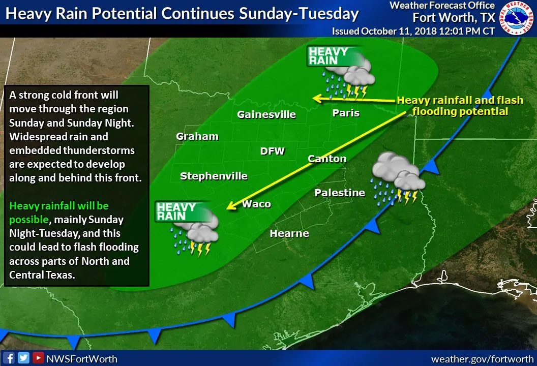
A significant precipitation event is becoming more likely to unfold beginning Sunday and continuing through Tuesday – perhaps longer – from the Concho Valley northeast to Texoma and Northeast Texas – south through North Texas, Central Texas, the Hill Country, east through the Brazos Valley, and East Texas. There is the potential of one to four inches of rain in this timeframe – on top of the rains expected with ‘Sergio’ and mentioned above. Many locations have saturated soils and thus can’t take too much new water. Flooding will likely be a threat during this timeframe, both in the form of localized flash flooding and another round of river/tributary flooding. The forecast for the middle to latter half of next week is also looking wet. Once we get through Saturday’s system we should be able to get a better grasp on relative zones of heavy rain and flood potential.
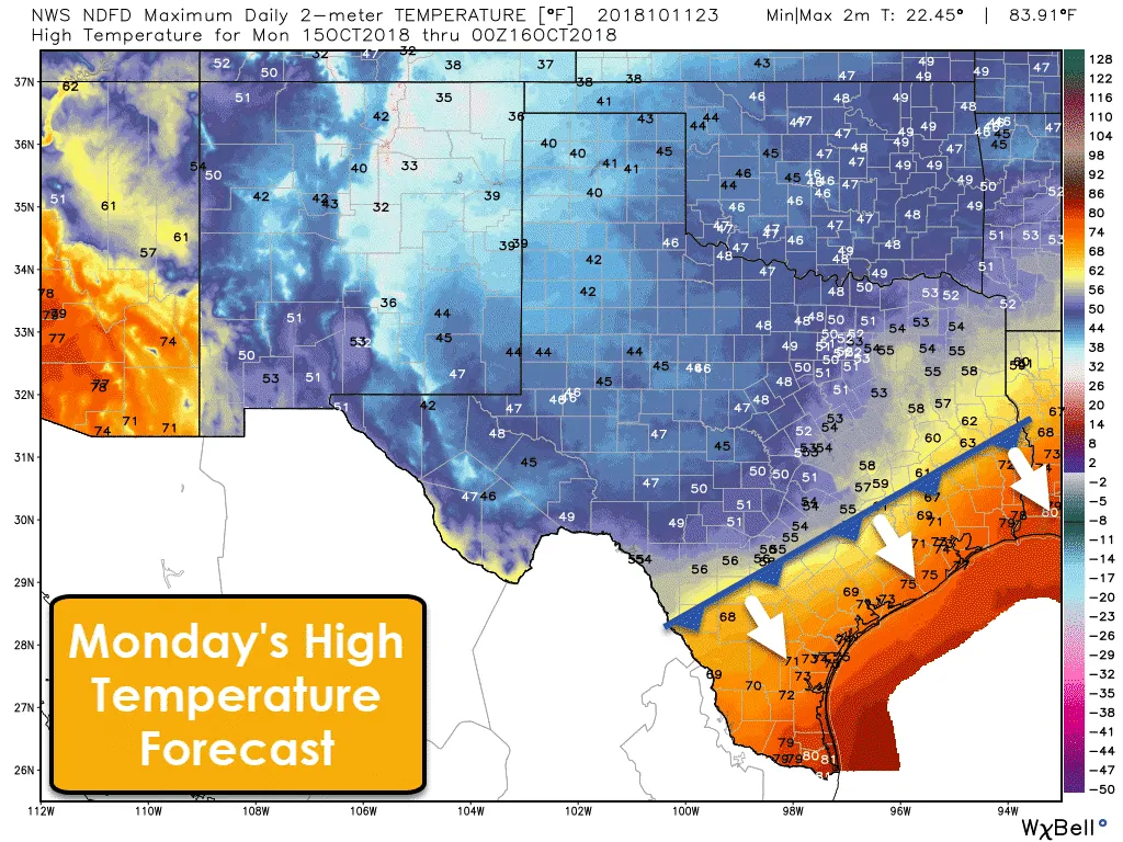
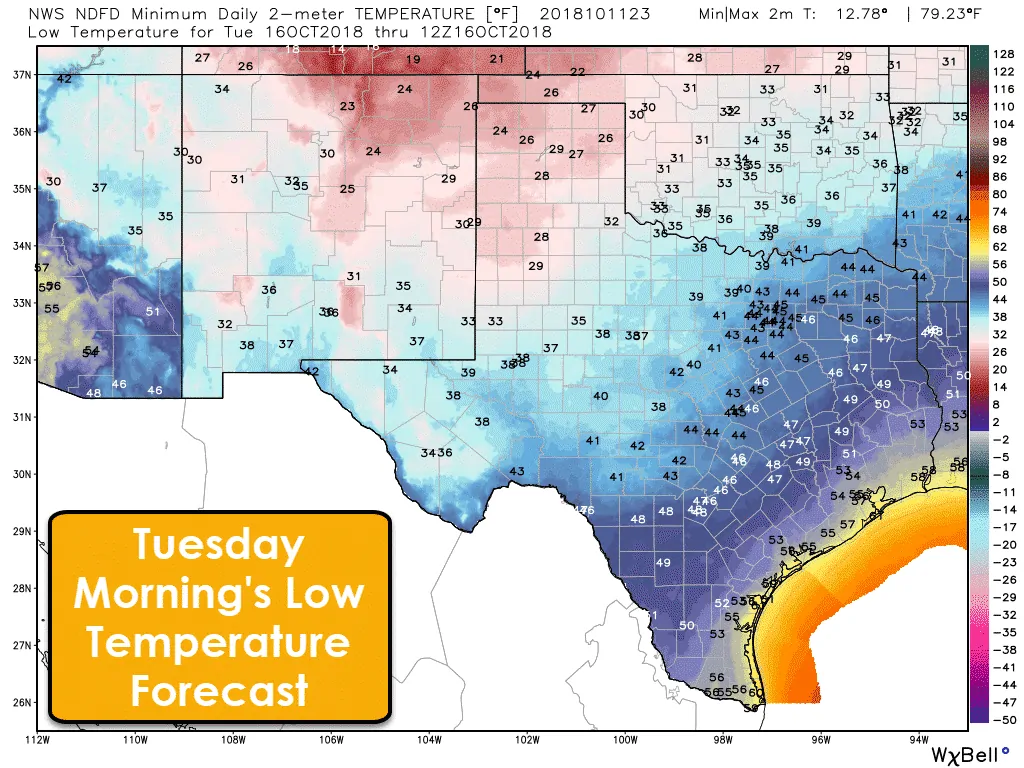
Early season arctic cold front arrives Sunday and Monday
An early season arctic cold front will arrive on Sunday and Monday as it plows south. The result will be high temperatures 20 to 30+ degrees below average for mid-October – and a hard freeze by Tuesday morning across much of the Texas Panhandle into West Texas. Future forecasts may even have to go colder than this if weather model data continues to come in colder.


0 Comments