
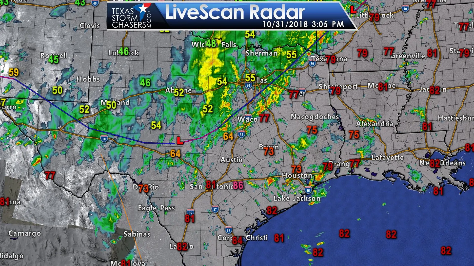
The cold front extends from near Pecos to Ozona to Gatesville to Canton to Clarksville. Gusty northwest winds and precipitation behind the front are making for dreary and rather winter-like conditions. Temperatures are down into the 40s across the Panhandle and West Texas with 50s south into the Concho Valley and across North Texas. Those south of the cold front are in the 70s to 80s. As you might expect the highest threat of severe thunderstorms will be in association with the cold front and with isolated storms ahead of the front. However, we can’t rule out some stronger storms with hail behind the cold front.
The severe weather forecast is a complex one with a few possible scenarios. The primary scenario will involve a line of thunderstorms that move south and east in association with the cold front this evening. Stronger thunderstorms within this squall line could produce damaging straight-line winds up to 70 MPH and isolated tornadoes. If we do see tornadoes evolve with the squall line they would probably be the brief/weak variety in association with higher-end straight-line winds.
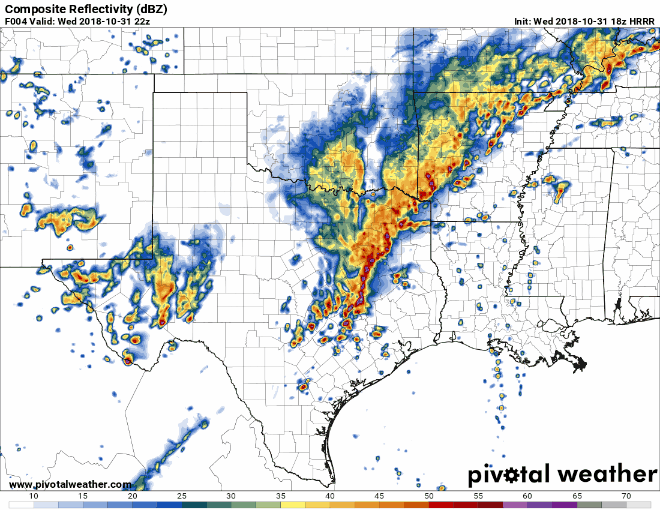
18Z HRRR: Simulated model weather radar from 4 PM and every hour through 4 AM Thursday.
A second concern is the threat of isolated thunderstorms that fire up ahead of the squall line. We’re seeing a few isolated storms across Southeast Texas as of 3 PM, but so far they are mostly behaving themselves. We can’t rule out an isolated tornado threat with those cells this afternoon. However, the threat of isolated supercellls may increase after 8 PM across far East Texas and eventually into Lousiana. Low-level wind shear will be impressive and thus there would be an enhanced tornado threat with pre-frontal thunderstorms (if they develop). This higher tornado threat will impact Lousiana and Mississippi late tonight.
The squall line will continue to move southeast this evening and eventually impact a good portion of Southeast Texas. Some storms may be severe as discussed above. The squall line should be moving off the Southeast Texas coast by 1 AM. Post-frontal showers and thunderstorms may continue into the early morning hours Thursday from South Texas into Southeast Texas, but severe storms would be unlikely by that point. South Texas and the Rio Grande Valley look like they’ll remain mostly capped, thus storms don’t appear as likely tonight compared to farther northeast.
We now have a relatively large tornado watch in effect through 10 PM. This watch includes a majority of the Brazos Valley, Southeast Texas, East Texas, and Northeast Texas. This watch will be clipped from west to east/north to south as the cold front progresses through this evening. Please have a way to receive weather warnings this evening.

Tornado Watch Number 416
   NWS Storm Prediction Center Norman OK
   300 PM CDT Wed Oct 31 2018

   The NWS Storm Prediction Center has issued a

   * Tornado Watch for portions of
     Southwestern Arkansas
     Northwestern Louisiana
     Extreme southeastern Oklahoma
     Much of east Texas
     Coastal Waters

   * Effective this Wednesday afternoon and evening from 300 PM
     until 1000 PM CDT.

   * Primary threats include...
     A few tornadoes likely
     Scattered damaging wind gusts to 70 mph likely
     Scattered large hail events to 1.5 inches in diameter possible

   SUMMARY...Thunderstorms will increase in coverage/intensity through
   the evening along a cold front across central and northeastern
   Texas, while other storms will continue to form ahead of the front
   across southeastern Texas.  The storm environment will become more
   favorable for rotating storms through the evening, with an attendant
   threat for a few tornadoes, damaging winds, and isolated large hail.


0 Comments