
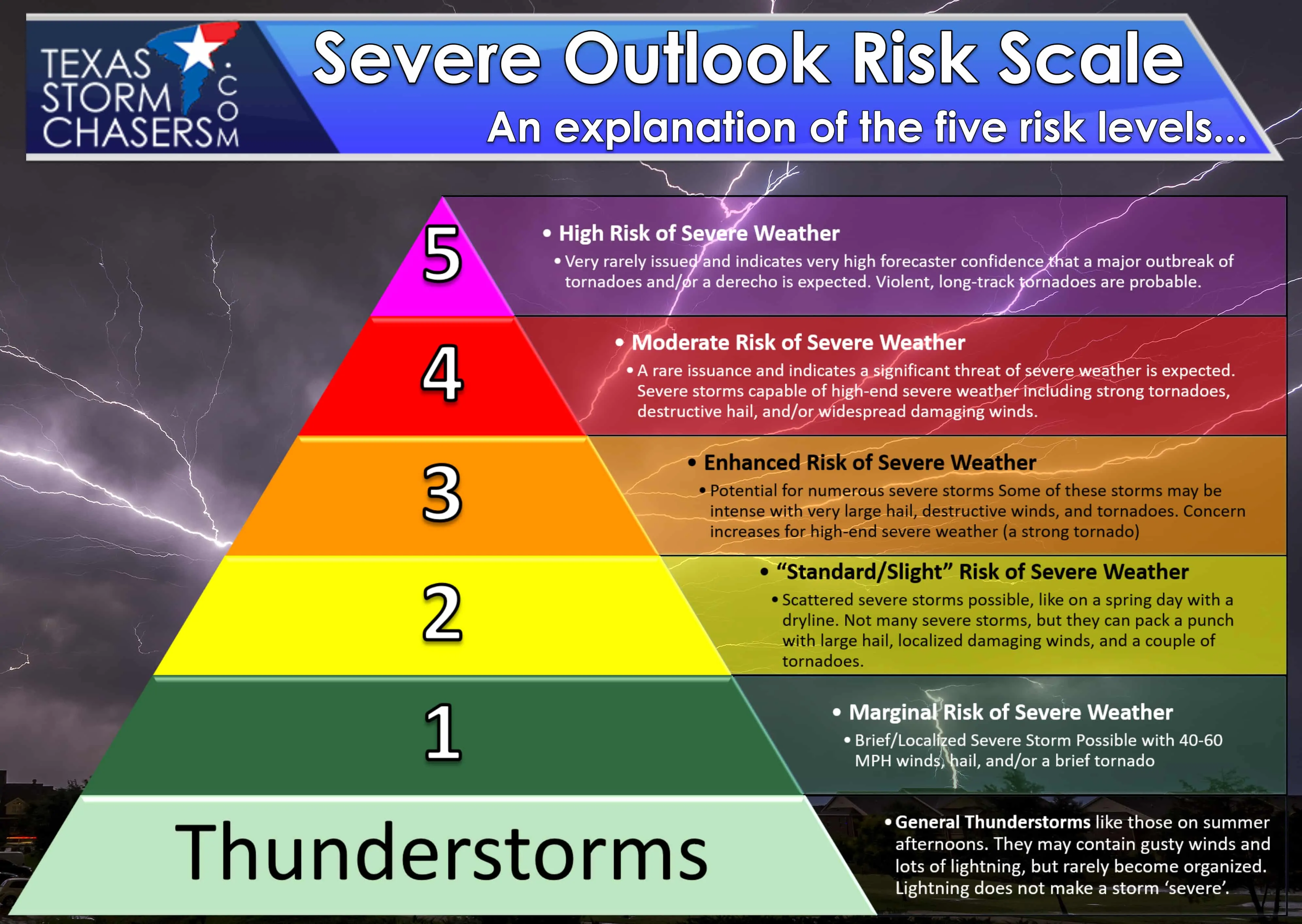
At times I feel like we all can get caught up in the ‘what level am I in’ syndrome. Please remember that thunderstorms don’t read maps and don’t care where they are in relation to a severe weather forecast. Pay attention if you’re located within or near a risk zone. Severe weather outlooks are based on the probability of severe weather occurring within 25 miles of any given point*.
Level 1 – 5%*
Level 2 – 15%*
Level 3 – 30%*
Level 4 – 45%*
Level 5 – 60%*
Once you get down to the day of an event the probability scale expands to delineate the specific threat of a tornado, damaging wind gusts, and large hail event. I won’t go that nerdy this morning, but you can find all that information for yourself here if interested.
Latest severe weather outlook for today
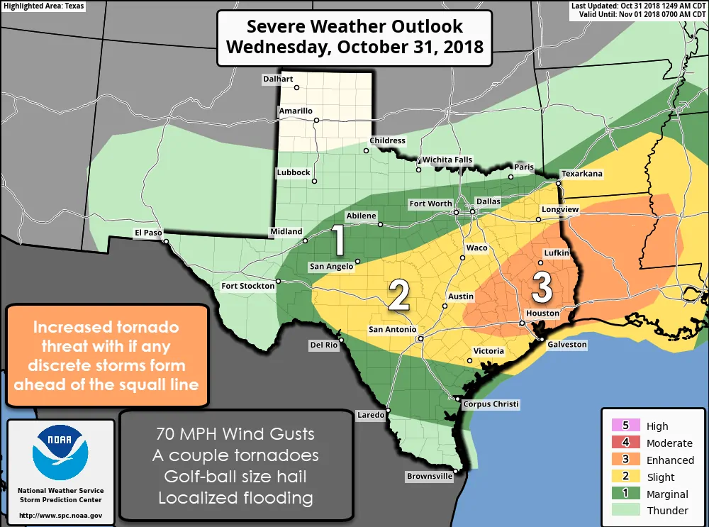
The early morning update from the Storm Prediction Center has maintained a level three risk zone for today across the Piney Woods of East Texas extending southwest through the Brazos Valley and Southeast Texas. This does include College Station, the Houston metro, and points north to Lufkin and east into Lousiana. The standard level two risk zone encompasses the Hill Country, South-Central Texas, Central Texas, the Coastal Plains, and Northeast Texas. Finally, we have a level one risk zone for the Concho Valley, Big Country, North Texas, and South Texas. Scroll up to see how these risk zones correlate to your chance of severe weather.
Some strong storms with hail are possible this morning from the Permian Basin east into the Concho Valley. This may continue into North Texas later this morning in association with the primary event expected this afternoon.
Details and timeline
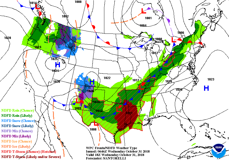
General surface pattern expected around noon today. Notice the area of low pressure developing east of Dallas with a trailing cold front extending back to the west.
Our primary forcing mechanism at the surface for thunderstorm development will be a southward moving cold front. With time a nearly solid line of thunderstorms should develop along the front. That line, along with the cold front, will move to the south and east this afternoon and this evening. The strongest thunderstorms within the squall line may produce damaging straight-line winds up to 70 MPH, hail up to the size of golf balls, and even a few tornadoes. The threat for a few tornadoes will be highest in the level three risk zone.
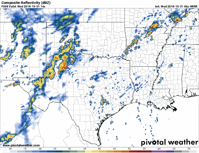
06Z HRRR: Simulated weather model radar beginning at 9 AM today and progressing forward one hour per frame through 12 AM Thursday. Remember – this is a model and should not be taken completely literally.
It now also looks probable that we will see a few discrete thunderstorms fire up ahead of the cold front this afternoon in East Texas and in Southeast Texas by the early evening. A strongly sheared airmass with adequate instability will be in place – supporting the potential for a supercellular storm mode. If we do have a discrete to semi-discrete supercelluar storm mode evolve the threat of tornadoes would exist. This possibility becomes more likely as the event begins to move into Lousiana, but we’re going to have to watch East Texas south into Southeast Texas closely as well.
Behind the cold front, a fairly shallow cool/stable layer will exist near the surface. A few thousand feet above the surface an unstable and warm airmass will remain in place (at least for a few hours after the frontal passage). This means thunderstorms may continue behind the front in that elevated instability axis, especially across the Hill Country and South-Central Texas this evening. Large hail would be the primary threat with the strongest storms.
An end to the storms and a few days of quiet weather
Current expectations have the cold front and associated squall line moving off the Texas coastline and through the Rio Grande Valley by about 4 AM Thursday. This will mark the end of precipitation chances and usher in a cooler airmass. It looks like that’ll keep us mostly dry through Thursday, Friday, and into the beginning of the weekend. Our next system may bring more precipitation chances as we get into the second half of the weekend and into the first full week of November.
As always we encourage you to check with the National Weather Service for your local weather forecast. Your local broadcast and digital meteorologists are great sources to stick with too!


0 Comments