
Members and an aircraft from the 53rd Weather Reconnaissance Squadron investigated Invest 95L in the western Gulf of Mexico this afternoon. They found a broad area of low pressure, but no well-defined surface low indicative of a tropical cyclone. There is still a chance that this broad low pressure may organize into a tropical depression tonight or Friday. Whether or not this remains a tropical low or a tropical depression is irrelevant to potential impacts. Rainfall and potential flooding continue to be the primary hazard.
Flash Flood Watches are in effect through Friday and Saturday across South-Central Texas, South Texas, the Coastal Plains, into the Rio Grande Valley. This upcoming rain event is complicated by heavy rains that have fallen over the last couple of weeks. Soils are saturated and the ground simply isn’t able to absorb any new rains that fall. Rains that fall will likely run-off and cause flooding more quickly/easily than what we might otherwise see. Many rivers across South Texas are elevated or in flood stage. Those rivers are expected to see new rises beginning this week and continuing into next week. I anticipate many low-water crossings or typical trouble-spots in urban areas will be closed at various points over the coming days.
Do you know the difference between a Flood Watch and a Flood Warning?
Warning means TAKE ACTION. Watch means BE PREPARED. https://t.co/6NkxAUBL6h #FloodSafety pic.twitter.com/KmUN9gbn7S
— NWS Austin/San Antonio (@NWSSanAntonio) September 13, 2018
This is typically where I’d share a simulated weather model radar image for the coming days. Unfourtinietly, the fickle nature of tropical downpours and rather broad structure of this system make that more difficult. There will likely be numerous showers and thunderstorms across the Rio Grande Valley, South Texas, South-Central Texas, and the Coastal Plains on Friday. The strongest activity may produce 1 to 3 inches of rain per hour. We may see a brief lull Friday evening, but precipitation coverage is expected to increase again by Friday Night into Saturday.
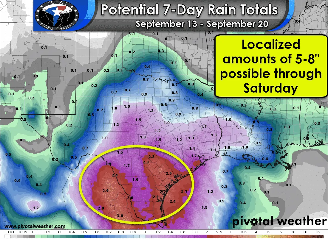
Widespread rain totals of 1 to 3 inches are expected across the aforementioned regions. Localized rain totals may approach 8 inches in some locations. Flash flood guidance (the amount of rain it would take to cause new flooding) are only in the 1.5 to 2 inch range for a 3 hour period. Given that one could see that much rain in 45 minutes in a tropical downpour there is definitely a legitimate concern. Remember: Soils are saturated and that’ll cause run-off/flooding much more easily than even a few weeks ago. We’ll have to deal with probable river flooding across South-Central Texas and South Texas well into next week.


0 Comments