
The National Weather Service in Houston has issued a Flash Flood Watch for portions of Southeast Texas. This watch is in effect late tonight through the evening hours tomorrow. A round of heavy rainfall is expected tonight as a non-tropical area of low pressure moves onshore. Saturated soils, abundant moisture levels, and slow movement of the rain could result in localized flooding. We’re not expecting widespread or significant flooding tonight. Still, if someone receives 3 inches of rain in one hour, that’ll cause some short-term flash flooding. Remember that it is difficult to determine the height of water flowing over a road. Turn around, don’t drown!
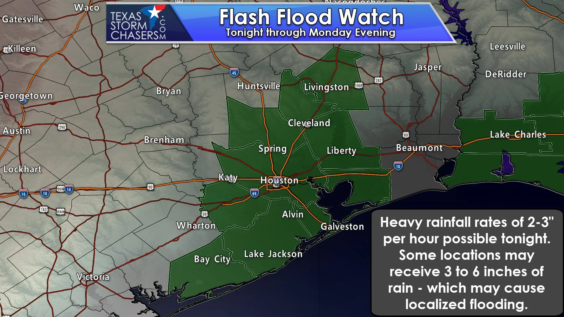
…FLASH FLOOD WATCH IN EFFECT FROM MIDNIGHT CDT TONIGHT THROUGH
MONDAY EVENING…
The National Weather Service in Houston/Galveston has issued a
* Flash Flood Watch for a portion of southeast Texas…including
the following counties…Brazoria Islands…Chambers…Coastal
Brazoria…Coastal Galveston…Coastal Harris…Coastal
Matagorda…Fort Bend…Galveston Island and Bolivar
Peninsula…Inland Brazoria…Inland Galveston…Inland
Harris…Inland Matagorda…Matagorda Islands…Montgomery…
Northern Liberty…Polk…San Jacinto and Southern Liberty.
* From midnight CDT tonight through Monday evening
* Slow moving thunderstorms are expected to develop over the watch
area producing periods of heavy rainfall. Deep tropical moisture
will spread over the region tonight and Monday fueling the
development of storms beginning around midnight. These storms
will be capable of 2 to 3 inch per hour rainfall rates given the
moist environment and slow movement. Rainfall totals of 1 to 3
inches can be expected with isolated totals of 5 to 6 inches.
Some areas that received moderate to heavy rainfall today will
be more prone to runoff and street flooding. The storms should
weaken by late Labor Day afternoon.
* Primary impacts will likely be street flooding and low water
crossings. Minor flooding is possible of streams and bayous in
the area though any flooding would likely be limited to just the
smaller watersheds.


0 Comments