
It’s been a ‘popcorn’ kind of week with popup storms impacting various regions of Texas. Those storms are good for the rains but quite detrimental to commercial aviation interests. Isolated to scattered thunderstorm chances will continue this afternoon and again on Friday. However, just in time for the weekend, the faucet is going to start shutting off.
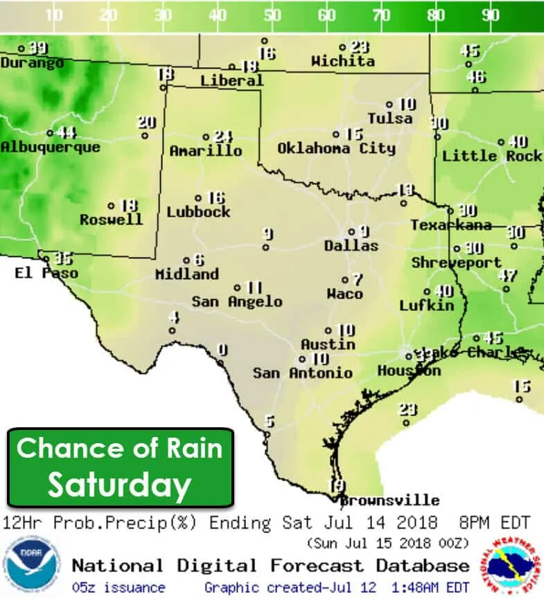
Sunday looks to be the driest of two days this weekend, but Saturday will be far from a washout. Isolated to widely scattered thunderstorms are expected across East Texas and Southeast Texas from the late morning into the afternoon hours Saturday. These storms will be the typical diurnal storms – quick to pop up, but usually raining themselves out within an hour. They can be dangerous with lightning, localized heavy rain, and gusty winds (microbursts).
The monsoon will bring isolated to widely scattered storms on Saturday in the Borderland, north/northeast through New Mexico into the Texas Panhandle. The highest coverage of rain will be in the Borderland with lower coverage in West Texas and the Panhandle. There is a chance of some showers during the morning hours across the Texas Panhandle and West Texas. Should the morning activity take place the afternoon may end up being drier.
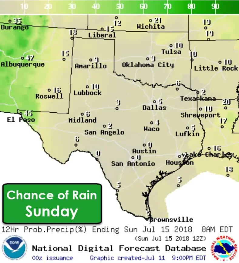
Scattered rain will continue in the Borderland on Sunday as the typical monsoon pattern continues. Everyone else in Texas has at least a 90% chance of staying dry. Rain may not be falling from the sky but it’ll be a day where a cool pool will be welcome.
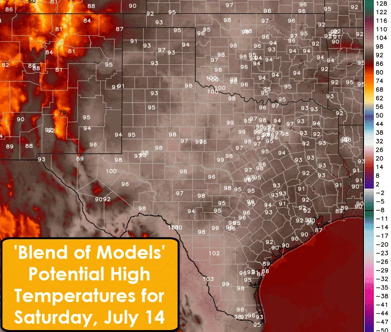
If it isn’t raining it is a good bet in July that it’s going to be hot. That’ll be true this weekend with high temperatures around seasonal averages for mid-July. High temperatures on Saturday should range from the lower 90s in Southeast Texas (where rain chances are highest) to the Upper 90s and Lower 100s (100F-103F) elsewhere in Texas. Those aren’t record-breaking numbers for July, but that’s still on the toasty side.
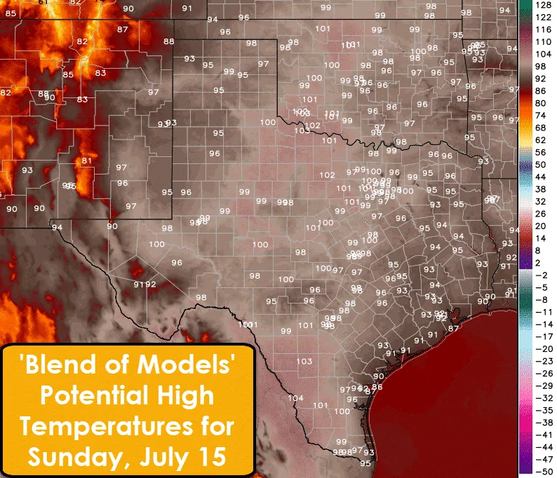
Sunday should be a few degrees warmer than Saturday with lower rain chances and ‘summer weather pattern’ in place. High temperatures will probably approach or make it into the triple digits across Northwest Texas south into the Edwards Plateau. Southwest Texas (Del Rio to Laredo) may make it into the mid 100s (102F-105F). Low rain chances, ongoing drought, and hot temperatures will result in an elevated risk of wildfires across Texas. Obviously, locations that have had recent rain will have a lower wildfire risk, but fuels can dry out quickly in the summer heat.


0 Comments