
Saturday and Sunday from the Borderland eastward into western sections of Texas
The remnants of Tropical Storm Bud have brought beneficial rainfall to parts of Mexico today. What’s left of Bud is moving north toward Arizona, New Mexico, and western portions of Texas. Severe thunderstorms aren’t expected to become a widespread hazard. A few stronger storms may occur on Saturday in the Permian Basin with small hail and gusty winds.
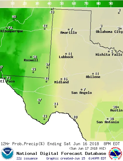
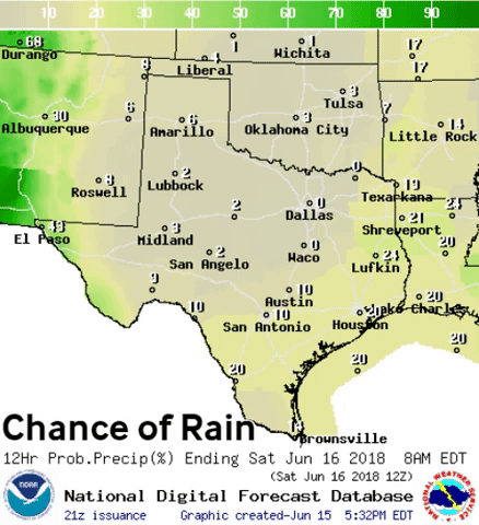
Saturday’s Chance of Rain
The chance of precipitation will increase markedly tomorrow across the Borderland with scattered to numerous showers expected. Isolated to scattered rain is expected across the Trans-Pecos, Permian Basin, into western parts of the Texas Panhandle and West Texas.
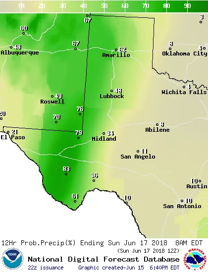
Chance of Rain Saturday Night. Some rainfall may be heavy.
Scattered to numerous showers will spread east into the Texas Panhandle, West Texas, Permian Basin, and Trans-Pecos. Thunderstorms are also possible, but severe weather (quarter size hail and winds over 58 MPH) are not expected. This is a tropical rainfall event versus a severe weather one. Localized heavy rain may result in some flood threat.
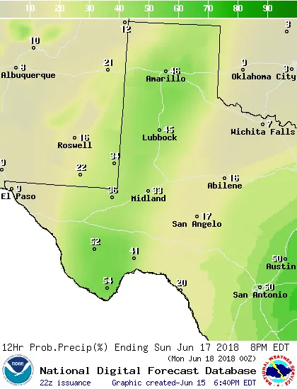
Sunday’s Chance of Rain
We’ll see shower and thunderstorm coverage begin to dwindle as we get into the daytime hours on Sunday. By the evening hours, Sunday coverage should be more isolated.
Flash Flood Outlook for western parts of Texas this weekend
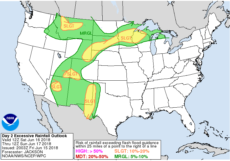
Saturday/Saturday Night’s Flash Flood Outlook
Increased moisture in the atmosphere from the remnants of TS Bud will allow for efficient rainfall rates. While there will be some ingredients needed for a heavy rain event, there are some missing ingredients. Localized flooding is anticipated on Saturday, Saturday Night, and Sunday across the Borderland, Permian Basin toward the Trans-Pecos, and into the western half of the Texas Panhandle and West Texas. Rain totals will vary and some localized rain totals exceeding four inches may occur. Those who receive several inches of rain over the two-day span – and especially those who see that amount of rain in a couple of hours – will have the highest threat for flooding. We’ll also have to watch any burn-scars for debris flows and an increased flash flooding threat.
Additional rain chances will arrive on Monday and continue into the upcoming week. We’ll talk about that in the section below.
Increasing Rain Chances Statewide This Weekend continuing well into Next Week
Separate from the West Texas rain chances this weekend we’ll see rain chances increase along the coast as well. Widely scattered showers and thunderstorms are expected tomorrow afternoon across Southeast Texas, the Coastal Plains, westward into South-Central Texas. This activity will mostly be diurnally-driven. Rain coverage should decrease with the ‘best’ chance of showers/storms tomorrow night being along the coast from Corpus Christi and points north/east.
Scattered to numerous showers and thunderstorms are likely on Sunday across Central Texas, the Brazos Valley, South Texas, the Middle Coast, Coastal Plains, into Southeast Texas and East Texas. Coverage will tend to be more scattered Sunday night.
With the exception of the Borderland, the entire state will probably see scattered to numerous showers and thunderstorms. This uptick in coverage will be due to a storm system moving inland from the Gulf of Mexico. That system is not expected to develop into a tropical cyclone, but it’ll still contain abundant amounts of atmospheric moisture.
Rain chances will continue daily through Thursday. Some locations will have higher chances of rain than others. Your preferred ‘weather app’ will be able to provide you with detailed precipitation chances for your specific location. We’ll focus on the regional scale along with the possibility of hazardous weather.
Latest Rain Total Forecast & Associated Flooding Risk
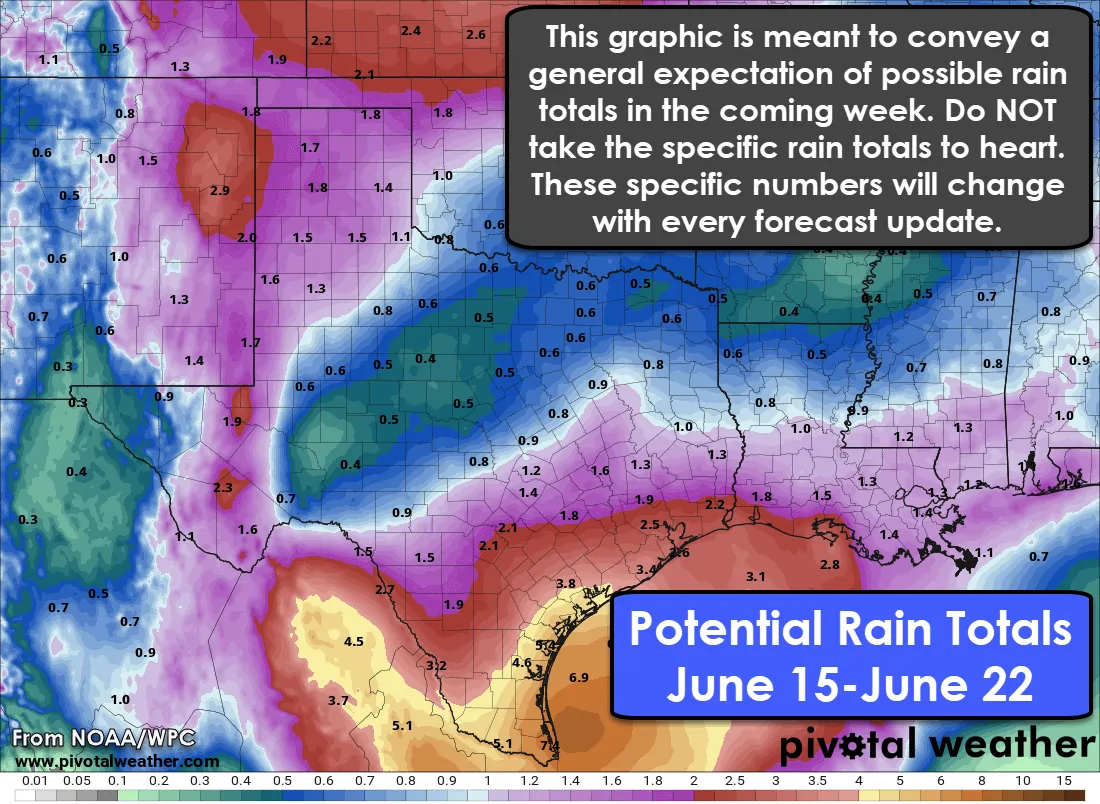
Ongoing drought conditions (dry weather) means most locations will be able to handle the upcoming rain with little to no flooding. A couple exceptions will exist that will result in a localized threat of flooding.
- Regardless of how dry it’s been as of late, any location that receives 2-3+ inches of rain in a one to two-hour span will have to deal with flash flooding. That will occur as local storm drainage systems work to drain all that water. Some locations are more prone to flooding (low-water crossings, construction zones, etc).
- We may see localized flooding occur next week in locations that receive several inches of rainfall. Once soils are saturated (which absent of a quick 2-4″ of rain will take several days) we’ll start to see the possibility of a few more flooding issues. The highest potential for that seems to be in the Coastal Plains south into Deep South Texas and the Rio Grande Valley.
- Compared to yesterday the potential heaviest axis of rainfall has shifted south. Instead of Southeast Texas, the highest rain totals may be over the Coastal Plains, Middle Coast, south into the Rio Grande Valley. 3-5 inches of rain falling over a couple of days will result in a far lower flood risk than the same 3 to 5 inches falling in 3 hours. It’ll be those localized higher amounts where we’ll have to watch for flooding.’
The rain total forecast above is based on a regional scale. There will be variations on rain totals over a city, not to mention a county. Don’t expect your eventual rain total to be exactly what is shown above. Since it is a seven-day forecast there will likely be adjustments. Some folks could see far less rain and some may see more. Some may see most of their rainfall over a several day span while others could see several inches of rain in a couple of hours. In terms of any eventual flooding – it’ll be more likely to occur where thunderstorms move over the same areas (training storms). Many streams and rivers are either dry or well within their ‘norms’. Some rises in streams/rivers are likely, but most should stay within their bounds.


0 Comments