
There have been a couple of changes to the rain forecast for the next couple of days. As I warned in previous posts, there usually are adjustments made to a forecast as we get closer to an event. The bad news is for those in the Concho Valley, Big Country, and North Texas who are going to end up between our two storm systems. There will be rain chances, but the ‘regional’ rain totals look to remain below one inch. As usual, some will see more and some will see less.
Tonight in the Panhandle, West Texas, and Permian Basin
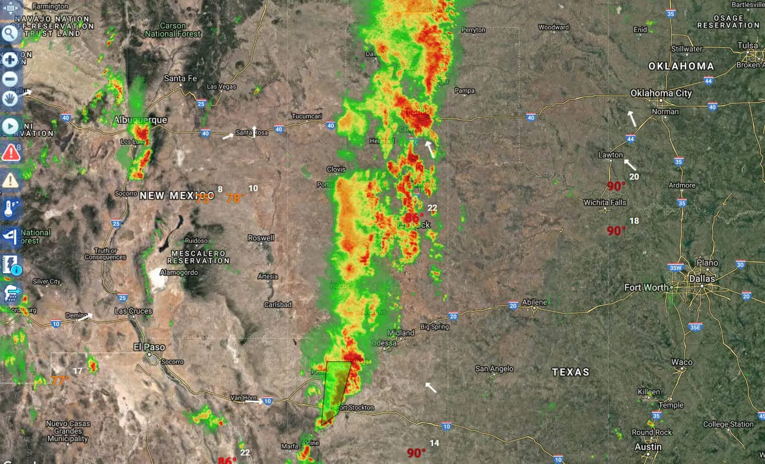
From our free interactive weather radar. You can view a real-time version by going to our Interactive Weather Radar in our main menu.
Scattered to numerous showers and thunderstorms are ongoing this evening across the Texas Panhandle, West Texas, south into the Permian Basin. Much of this is thanks to the moisture from what was Tropical Storm Bud in the Pacific. Some of the storms did produce damaging wind gusts this afternoon, but none are severe at the time of this writing. I expect the primary hazard tonight will be in the form of heavy rainfall. Most locations will need to see 4 to 5 inches of rain before flash flooding becomes an increased threat. However – that number drops to 2-3 inches if that amount of rainfall falls within a one to two-hour span. Localized flooding is a threat tonight, especially across the Permian Basin and West Texas. Some spots may see up to five inches of rain tonight in those regions. More widespread rain totals should be in the one-half to the two-inch range.
Rain chances ramp up Sunday along the coast and adjacent inland regions
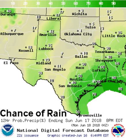
Scattered showers and a couple of thunderstorms will begin in earnest on Sunday as tropical moisture advects inland from the Gulf of Mexico. We still do have our disorganized storm system out there, but development into a tropical cyclone is unlikely. Gusty winds are helping to cause increased tidal flows and wave action along the Texas coastline. High rip current danger will continue into Sunday as well.
The highest coverage of rain will be during the daytime hours. Coverage of rain should be lower at night and closer to the coast. The intensity of rainfall may actually be highest at night in closest proximity to the storm system. These ‘warm-core’ systems tend to act like an ice skater. During the day the rain extends out, but contracts back toward the system at night. This process may continue daily through Wednesday, if not Thursday.
Latest rain total forecast through Thursday
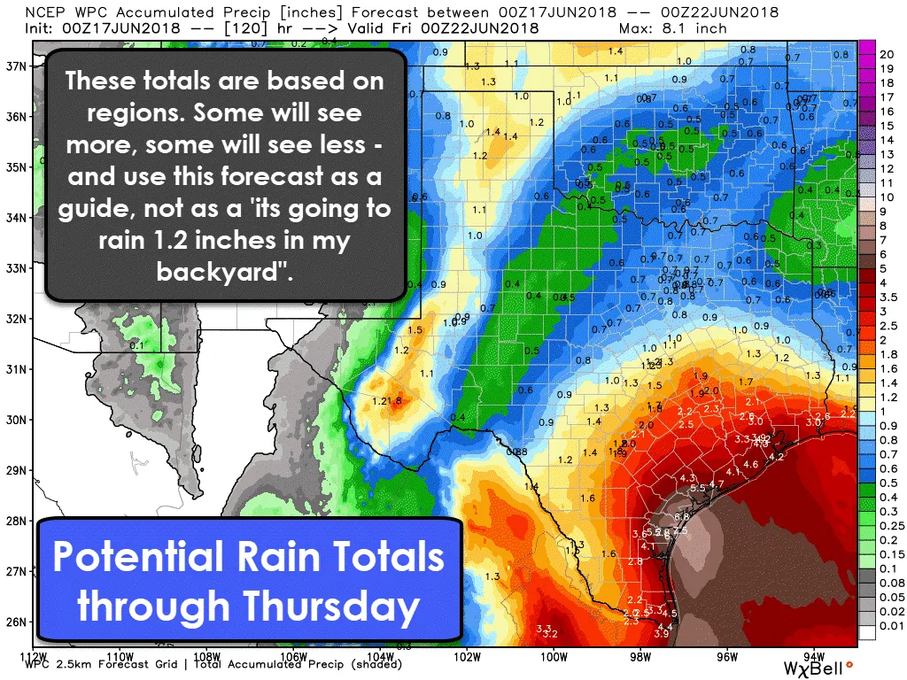
The rain-totals being depicted on this forecast in the Texas Panhandle, West Texas, and Permian Basin is mostly due to the convection ongoing tonight and into Sunday. Additional chances of rain will exist this week, however. In terms of our Gulf system, the highest rain totals are expected to be across the Rio Grande Valley, Middle Coast, Coastal Plains, and Southeast Texas. The closer to the coast the higher the rain totals are expected to be.
This rain-total forecast is regionally based. While the graphic itself does show specific rain totals, I don’t want you to take those literally. Think of this as a ‘range’ versus a specific number forecast. Within a small area, some may end up seeing more than the rain graphic shows while others may end up getting less. The numbers could also shift as some uncertainties remain regarding the strength of the storm system. If it comes in a bit stronger that would result in more rain.
Localized flooding is expected to be a threat where the heaviest rains fall. If we see 3 inches of rainfall over a 24 hour period that is unlikely to cause too many flooding issues. If we see 3 inches of rain in 1 hour that is likely to cause flash flooding. Most rivers and tributaries are either low or near their normal levels. They can handle the rain, but it takes time for water to drain into those stormwater systems. We’ll be keeping an eye on trends in case numbers end up increasing. [click_to_tweet tweet=”Widespread flooding is not expected across Texas in the coming days based on the current rainfall forecast. Localized flooding is a threat beginning Sunday, especially from Corpus Christi northeast toward Galveston. #txwx ” quote=”This is not looking like a high-end flood event at this time, but localized flooding will be possible across the Middle Coast, Coastal Plains, and Southeast Texas. “]
As for those heading to the coast for a vacation – it shouldn’t be raining the entire time through Wednesday, but I’m afraid the weather isn’t exactly pristine for beach time. Rip currents will be a high risk along with the threat of some coastal flooding during high tide.


0 Comments