
May is a day away and Mother Nature certainly seems to realize that. Severe weather chances returned to western portions of Texas yesterday with storms producing large hail and gusty winds. The same threats will return today across the Texas Panhandle south into the Permian Basin. A low-end tornado risk will also be present.
Tomorrow may be a quiet, but windy day across Texas. That’ll change as we see higher-end severe weather probabilities develop on Wednesday and Thursday – each farther east than the day before.
Needless to say, we’ll be chasing and should have live video available. See our social media channels for chase-related updates. This blog post will be dedicated to providing day-to-day information on severe weather chances in Texas.
Today, April 30
Severe Weather Outlook
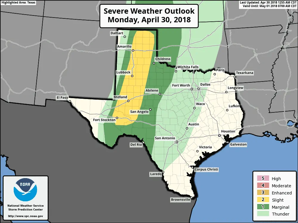
The standard level two risk of severe weather encompasses a corridor from the northern Texas Panhandle south/southwest through West Texas into the Permian Basin. The western edge of this risk will be the dryline. The risk zone extends about four counties to the east of the dryline. Those in this zone will have a 15% chance of having severe weather occur within 25 miles of their location.
A marginal level one risk of severe weather runs eastward into western Oklahoma, Northwest Texas, the Big Country east to Abilene, the Concho Valley, and Edwards Plateau. This zone has a 5% chance of having severe weather occur within 25 miles of a given point – mainly during the evening hours. In all likelihood, storms will not make it this far east, but there is a small chance they manage to survive into the mid-evening hours before the cap smashes them down.
Threats
A weakening cap in the presence of strong afternoon heating should allow isolated to widely scattered storms to fire up just east of the dryline by the late afternoon. Storms will try and move to the east at 20 to 30 MPH. Ingredients in place will support organized storm modes.
The strongest storms may produce very large hail up to the size of baseballs along with localized wind gusts over 70 MPH. If an organized supercell managed to maintain itself past 8 PM a very localized tornado threat could develop. However – the overall tornado threat is very low today thanks to high cloud bases this afternoon.
Timing and Discussion
Storms will generally weaken after 8-9PM as the cap quickly strengthens. One or two more persistent storms may try and continue into the mid-evening and push east toward the Texas Panhandle/Western Oklahoma state line along with the Big Country and Concho Valley. Any storms that managed to push that far east would be very few and far between.
Tuesday, May 1

It now appears likely the cap will be too strong for thunderstorms to develop in Texas on Tuesday. The dryline should be pushing into western Oklahoma by the late afternoon. I can’t rule out a brief/very isolated storm in the eastern ~10 miles of the Texas Panhandle tomorrow, but they’d move into Oklahoma before they got too intense. We’ll keep an eye on data just in case the dryline is able to stay a bit farther west.
Wednesday, May 2
Higher severe weather probabilities already in place
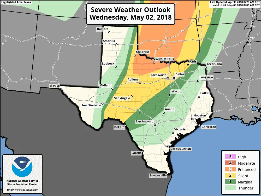
Wednesday has the potential of being an active severe weather day across the Southern United States. There remain several questions and the answers to those questions will dictate exactly the overall severe weather threat and modes.
A level three – an enhanced risk of severe weather now includes much of Northwest Texas. Shown in orange, this enhanced severe weather risk includes the western two-thirds of Oklahoma and the eastern half of Kansas. Anyone in or near this enhanced risk has a 30% chance of severe weather occurring within 25 miles of a given point. Those are high probabilities for an outlook three days out.
A level two risk of severe weather includes the northwestern half of North Texas, the Big Country, the Concho Valley, and portions of the Edwards Plateau. San Angelo, Abilene, D/FW, and Paris are included. This standard risk level means those within and near the zone have a 15% chance of severe weather within 25 miles of a given point.
Finally – a level one marginal risk includes the Hill Country and runs south and east of the higher probabilities.
These outlook lines WILL CHANGE in future updates. If you’re in or near any of these risk zones consider this a heads up you need to check back on Tuesday and Wednesday for updates.
Threats with Wednesday’s Storms
The western edge of the risk zone will be the dryline’s location on Wednesday. Questions regarding cloud cover, cap strength, and the strength of low-level winds exist. At this point, there certainly looks to be a substantial threat of very large hail with the strongest storms on Wednesday.
Hail sizes could approach the size of softballs in the strongest storms. Localized damaging wind gusts over 65 MPH will be possible. Any cluster or squall line would have an enhanced risk of producing wind gusts over 70 MPH. The potential for tornadoes will be highest in the level three risk zone (shaded in orange).
While tornadoes will be a threat, the exact magnitude of that threat is still uncertain. We’ll get a better grasp on the tornado threat as we get closer to Wednesday. At this point, the highest tornado threat looks to be in Oklahoma where an outlook upgrade may occur in later updates.
The highest threat for severe weather will be during the late afternoon and evening hours.
Thursday, May 3
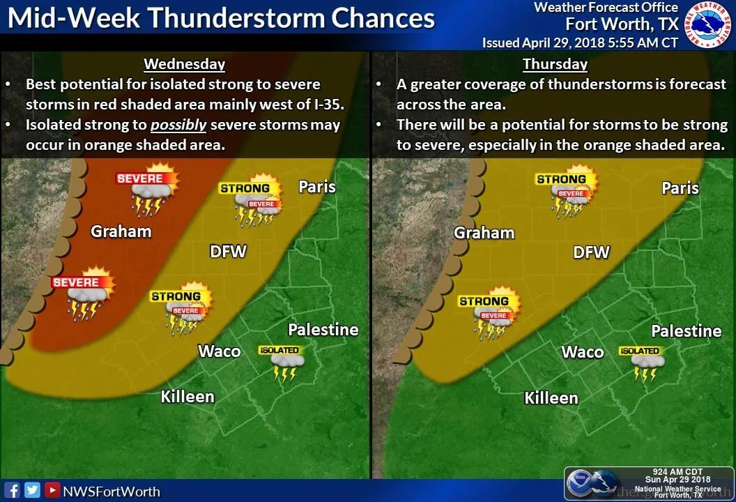
Wednesday’s severe weather will play a role for Thursday. The dryline should be farther east on Thursday. Being early May means there probably will be at least some severe weather threat east of the dryline. This could include North Texas with isolated storms possible farther south/southwest into the Concho Valley and Edwards Plateau.
Large hail and localized damaging winds could occur with the strongest storms. Specific severe weather hazards can’t be determined this far out, but at least a low-end tornado threat could exist due to strong instability values and plentiful moisture.
Let’s get past today before we start looking too much at Thursday. We still have to deal with Wednesday as well.
May is coming. Review your storm safety plan!
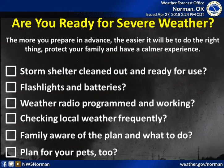
I think the message should be that even though we’ve had a quiet spring tornado season across the Southern United States thus far – that looks like it is going to change this week. May is one of our busiest (if not the busiest) severe weather months. Severe storms are not unusual nor are any of the upcoming risks. Review your safety plan, practice it, and you’ll be good to go if you have any bad weather approach this week.


0 Comments