
After several days of more tranquil weather, we’ll be dealing with a more active day tomorrow. A cold front will push south at a brisk pace on Tuesday. Besides a rather potent northerly wind shift, we’ll see the chance of thunderstorms across portions of Texas. This front will not bring an abnormally cold airmass. However, any cool front in spring typically has a chance of sparking off thunderstorms.
Severe Weather Risk Zones

Severe Weather Outlook for Tomorrow. (New outlook will be issued after 12:30 PM)
A level two risk – the ‘standard’ risk level for severe weather outlooks – includes Northeast Texas, East Texas, the Brazos Valley, and Southeast Texas. The risk runs along/east of a Clarksville to Kaufman to Gatesville to San Marcos to Hallettsville to Angleton line.
The level two risk means a fifteen percent chance of severe weather within 25 miles of a given point. Another way to think about that is a fifteen percent (15%) chance of severe weather within 25 miles of your home.
A level one risk runs east of a Sherman to Fort Worth to Hico to Fredericksburg to San Antonio to Beeville to Rockport line. A level one risk means a five percent (5%) chance of severe weather within 25 miles of any given point.
I realize I just covered a large area of real estate. Understand that these lines are just projections. Thunderstorms don’t read maps and certainly don’t care about them. The exact line placement will be redrawn this afternoon and five more times on Tuesday.
Timing
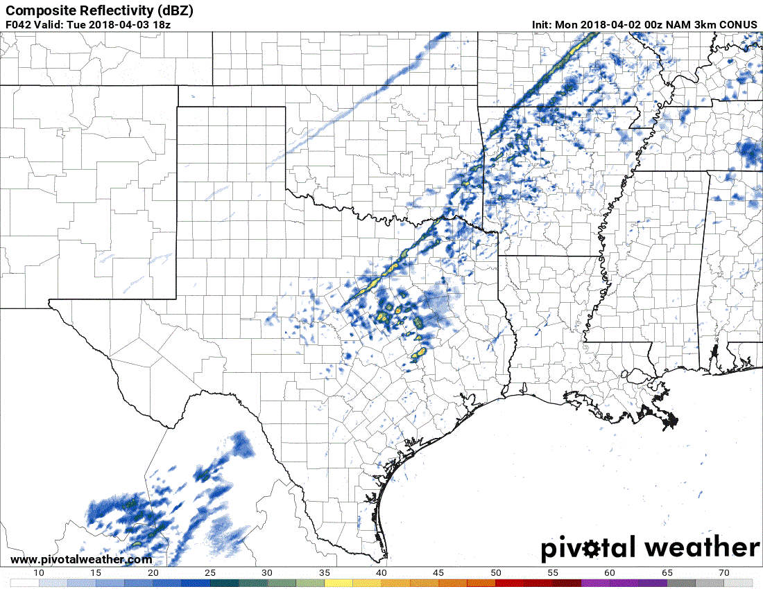
Simulated radar from the Monday Evening run of the North American Model. Times are in eastern on the top-right part of the graphic. This is only one model’s attempt at depicting tomorrow’s setup. Timing and location aspects will probably chance, but you get the general idea that it should be a ‘squall line’ along the cold front.
The best chance for severe thunderstorms will be 3 PM to 10 PM Tuesday. Isolated stronger storms are possible before that time.
Depending on the cold front’s speed the threat may continue past 10 PM in Southeast Texas. Likewise, a faster cold front could reduce the northwestward extent of the risk.
Thunderstorm chances will end when storms exit Texas to the east and move offshore into the Gulf of Mexico.
Threats
A fast-moving cold front tends to favor a linear storm mode. This looks to be the case tomorrow.
The highest (relative) threat for severe weather should be in the form of damaging straight-line wind gusts and large hail.
A few wind gusts may locally exceed 65 MPH. Not all storms in the squall line will be severe.
A few hailstones may approach the size of a golf-ball.
Tornadoes are not particularly likely with this setup. The threat for tornadoes is low, but not zero. A tornado can’t be ruled out if we see a particularly intense squall line develop.
A low risk for tornadoes will exist if we have any discrete supercells develop ahead of the line. It only takes one tornado coming down your street to make it a bad day.
Specific threat-hazards will be refined as newer data arrives. The next severe weather outlook will be issued around 12:30 PM today.
Possible Alternatives
1) The cold front ends up moving faster than expected. This would reduce the north/northwestward extent of the severe weather threat. It would also ‘move up’ the thunderstorm timeline.
2) Thunderstorms get undercut by the fast moving cold front, thus keeping them ‘elevated’ above a surface layer of cooler air. This would not totally eliminate the threat of hail but would lessen the overall severe weather risk.
3) Low-level shear is stronger than expected ahead of the cold front.
- This would result in a slightly higher (albeit still low) tornado threat. While wind shear will be present tomorrow it is expected to be unidirectional (or out of the southwest). We would need to see substantial changes in the expected setup for a higher-end tornado threat to materialize. This is unlikely.
After Tomorrow
Wednesday and Thursday will generally be spring-like and quiet. Another storm system and cold front will bring thunderstorm chances on Friday and Saturday. We’ll deal with that once we get past tomorrow’s system.


0 Comments