
The next twenty-four hours will bring the best chance of rain the Texas Panhandle and West Texas since last September. I’m hopeful a vast majority will receive measurable rainfall through Saturday morning. This isn’t a drought buster by any stretch of the imagination. I’m hopeful there will be just enough rain to kick-start the spring green-up.
Severe Weather Risk Today in Far Western Texas
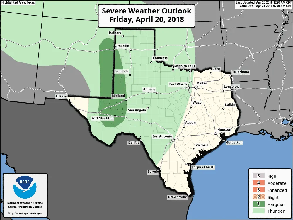
A level one risk of severe weather is in place today across far eastern New Mexico into the southwestern Texas Panhandle, far western Texas, and portions of the Permian Basin. The primary timeframe for severe storms looks to be between 4 PM and 9 PM. Meager moisture values will limit the available convective available potential energy (instability) needed to produce severe thunderstorms. Wind shear values (both speed and directional) are quite impressive, so we’ll have to keep an eye out for a few stronger storms.
Localized wind gusts up to 70 MPH and hail up to the size of ping-pong balls would be the primary threat with the strongest storms. Cloud bases should be too high to support much of a tornado threat, although a brief supercellular or landspout tornado can’t be ruled out.
Hallelujah! It’s going to rain in drought’s hardest hit regions
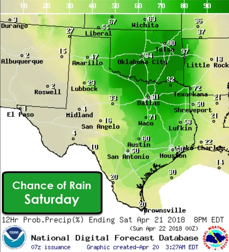
Precipitation chances will expand eastward on Saturday with scattered to numerous showers/storms expected across the eastern half of Texas, extending northwest along the Red River through Texoma and into the eastern Texas Panhandle. The best chance for rain will be during the first half of the day across the Texas Panhandle and West Texas. Rain chances will increase during the second-half of Saturday in locations farther east.
Severe Storm Risk shifts east on Saturday
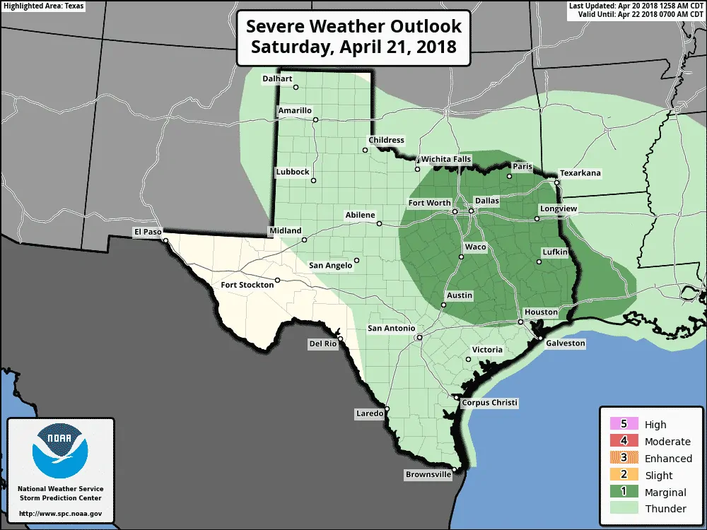
A level one risk of severe weather is in place across North Texas, Central Texas, East Texas, the Brazos Valley, and most of Southeast Texas tomorrow and tomorrow night. There remain several questions in regards to the extent of any potential severe weather threat tomorrow. Cloud cover and plenty of showers may limit the amount of instability available. There is also some uncertainty in the position of any outflow boundaries.
I wouldn’t be surprised to see parts of North Texas upgraded to the standard level two risk in later outlooks. Localized wind gusts up to 60 MPH and hail up to the size of golfballs will be the primary threat. An isolated tornado threat may develop tomorrow afternoon in western North Texas if discrete storms can interact with outflow boundaries. An outflow boundary tends to locally enhance low-level wind shear.
Storms may grow upscale into a squall line that moves east tomorrow evening and night with a threat of localized damaging wind gusts.
Rain Chances Saturday Night and Sunday
Rain chances are high Saturday Night across Northeast Texas and East Texas. Scattered activity is possible across Central Texas into the Brazos Valley and Southeast Texas. While showers can’t be ruled out Sunday morning in eastern Texas, we should see an end to rain chances by the early afternoon on Sunday.
<h4?How much rain?
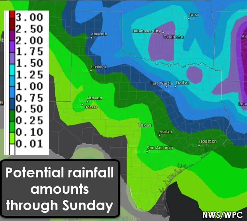
The heaviest rainfall amounts with this system are expected across the Texas Panhandle southeast through Northwest Texas, North Texas, Northeast Texas, and East Texas. Those regions have a decent shot of seeing widespread one quarter to three-quarters of an inch of rain. Northeast Texas could see one to one and a half inches of rain. As always, these numbers are regionalized. Amounts will vary locally. Rainfall amounts will be lower with south/southwestward extend. Flooding is not expected.
A little teaser of what’s to come?
Another storm system could bring another round of rain to Texas during the Tuesday-Thursday timeframe next week. At this point, it looks like rain chances would also include our drought-impacted regions in western Texas. Hopefully, this weekend’s system marks a wetter pattern change!


0 Comments